Dataset Identifier:
as_pibhmc_swa_bathy40m_hillshade
Citation:
Citation Information:
Title: NOAA/PIBHMC 40-m Bathymetry: American Samoa: Swains: Hillshade
Originator: Pacific Islands Benthic Habitat Mapping Center (PIBHMC)
Publication Date: January 25, 2016
Description:
Abstract:
A 40-m resolution gridded digital elevation model (DEM) for the bathymetry (ocean depth) surrounding Swains Island in American Samoa compiled from ship-borne multibeam sonar surveys. Almost complete bottom coverage was achieved in depths between 7 and 4800 m. Data collected by the Pacific Islands Benthic Habitat Mapping Center (PIBHMC) in support of NOAA's Coral Reef Conservation Program. Not to be used for navigational purposes. For the related dataset containing numeric bathymetry values for this image layer, see http://pacioos.org/metadata/pibhmc_bathy_40m_swains.html
Purpose: PacIOOS provides timely, reliable, and accurate ocean information to support a safe, clean, productive ocean and resilient coastal zone in the U.S. Pacific Islands region.
Spatial Domain:
Bounding Coordinates:
West Bounding Coordinate: -171.21862°
East Bounding Coordinate: -170.93795°
North Bounding Coordinate: -10.93548°
South Bounding Coordinate: -11.18830°
Keywords:
Theme:
Theme Keyword Thesaurus: GCMD Science Keywords
Keyword: Earth Science Oceans Bathymetry/Seafloor Topography Bathymetry Topographical Relief Maps
Place:
Place Keyword Thesaurus: GCMD Location Keywords
Place Keyword: Ocean Pacific Ocean South Pacific Ocean Polynesia American Samoa Swains
Access Constraints:
None
Use Constraints:
Use Limitation: The data may be used and redistributed for free but is not intended for legal use, since it may contain inaccuracies. Neither the data Contributor, University of Hawaii, PacIOOS, NOAA, State of Hawaii nor the United States Government, nor any of their employees or contractors, makes any warranty, express or implied, including warranties of merchantability and fitness for a particular purpose, or assumes any legal liability for the accuracy, completeness, or usefulness, of this information.
Point of Contact:
Contact Information:
Contact Organization Primary:
Contact Organization: Pacific Islands Benthic Habitat Mapping Center (PIBHMC)
Contact Electronic Mail Address: pibhmc@soest.hawaii.edu
Data Set Credit:
The Pacific Islands Ocean Observing System (PacIOOS) is funded through the National Oceanic and Atmospheric Administration (NOAA) as a Regional Association within the U.S. Integrated Ocean Observing System (IOOS). PacIOOS is coordinated by the University of Hawaii School of Ocean and Earth Science and Technology (SOEST).
Browse Graphic:
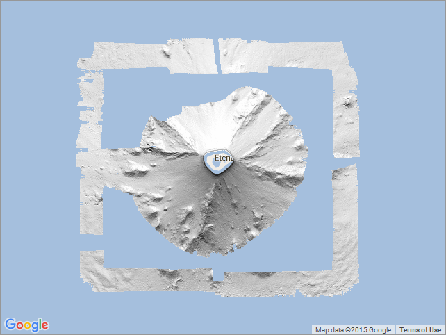
View full image
Browse Graphic File Name: http://www.pacioos.hawaii.edu/metadata/browse/as_pibhmc_swa_bathy40m_hillshade.png
Browse Graphic File Description:
Sample image.
Browse Graphic File Type: PNG
Back to Top
