Citation:
Citation Information:
Title:
CRRF Weather Station: Palau: Koror: Ngeanges Island
Date:
Date: March 1, 2007
Date Type:
creation
(CI_DateTypeCode)
Identifier:
Code:
aws_crrf
Authority:
org.pacioos
Responsible Party:
Individual Name: Sharon Patris
Organization Name: Coral Reef Research Foundation (CRRF)
Contact:
Contact Address:
Email:
crrfpalau@gmail.com
Online Resource:
Linkage: https://coralreefpalau.org
Protocol:
http
Function:
information
(CI_OnLineFunctionCode)
Contact Role:
originator
(CI_RoleCode)
Responsible Party:
Organization Name: Coral Reef Research Foundation (CRRF)
Contact:
Contact Address:
Email: crrfpalau@gmail.com
Online Resource:
Linkage: https://coralreefpalau.org
Protocol:
http
Function:
information
(CI_OnLineFunctionCode)
Contact Role:
originator
(CI_RoleCode)
Responsible Party:
Organization Name: Pacific Islands Ocean Observing System (PacIOOS)
Contact:
Contact Address:
Email:
info@pacioos.org
Online Resource:
Linkage: http://pacioos.org
Protocol:
http
Function:
information
(CI_OnLineFunctionCode)
Contact Role:
publisher
(CI_RoleCode)
Suggested data citation: Patris, S. and Coral Reef Research Foundation (CRRF). 2007, updated 2022. CRRF Weather Station: Palau: Koror: Ngeanges Island. [Indicate temporal subset used.] Distributed by the Pacific Islands Ocean Observing System (PacIOOS). http://pacioos.org/metadata/aws_crrf.html. Accessed [date].
Abstract:
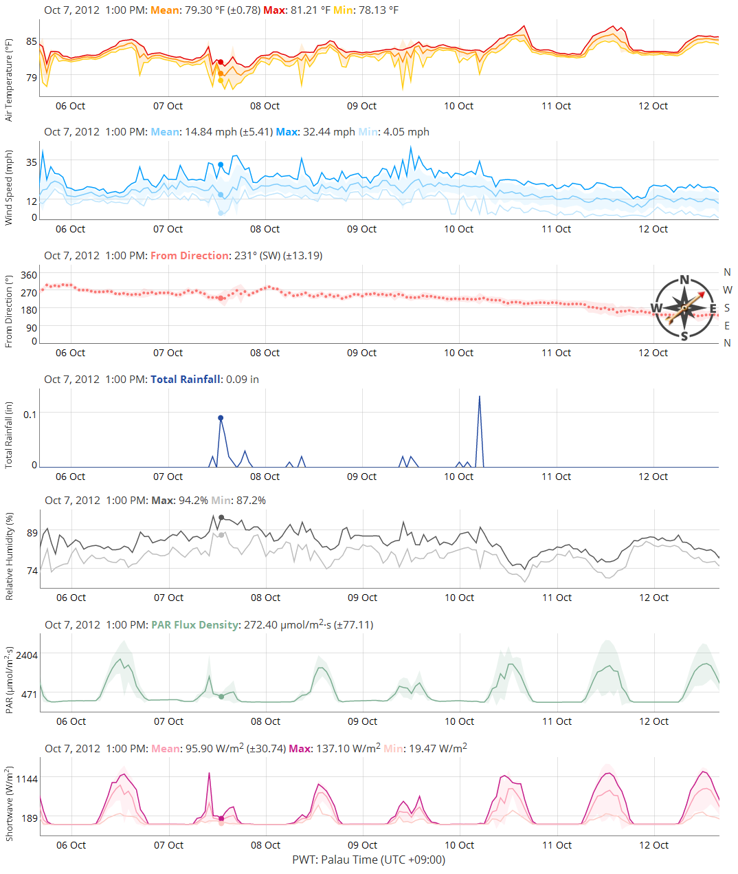
Since 2007, the Coral Reef Research Foundation (CRRF) has operated a Campbell Scientific automatic weather station (AWS) in Palau designed to measure meteorological/atmospheric conditions relevant to Koror State's Rock Islands Southern Lagoon, a World Heritage Site. With little flat land in the Rock Islands, the weather station is located on a 40-ft tower situated on a karst ridge on Ngeanges Island at 100 ft elevation, about 5.4 km (3.5 mi) from CRRF's study site at Jellyfish Lake. It measures a suite of atmospheric conditions for comparison with CRRF's temporary, floating weather station located on a tripod in Jellyfish Lake, and provides vital data for studying how local weather conditions and ENSO events affect the marine lake environment.
Purpose:
PacIOOS provides timely, reliable, and accurate ocean information to support a safe, clean, productive ocean and resilient coastal zone in the U.S. Pacific Islands region.
Credit:
This weather station is owned and operated by the Coral Reef Research Foundation (CRRF). The original deployment and maintenance of the station was funded by the David and Lucille Packard Foundation for 8 years, with government permission by Koror State. The Pacific Islands Ocean Observing System (PacIOOS) is funded through the National Oceanic and Atmospheric Administration (NOAA) as a Regional Association within the U.S. Integrated Ocean Observing System (IOOS). PacIOOS is coordinated by the University of Hawaii School of Ocean and Earth Science and Technology (SOEST).
Point of Contact:
Responsible Party:
Individual Name: Sharon Patris
Organization Name: Coral Reef Research Foundation (CRRF)
Contact:
Contact Address:
Email:
crrfpalau@gmail.com
Online Resource:
Linkage: https://coralreefpalau.org
Protocol:
http
Function:
information
(CI_OnLineFunctionCode)
Contact Role:
pointOfContact
(CI_RoleCode)
Browse Graphic:
View full image
Image File: http://www.pacioos.hawaii.edu/metadata/browse/aws_crrf.png
File Description:
Sample image.
Browse Graphic:
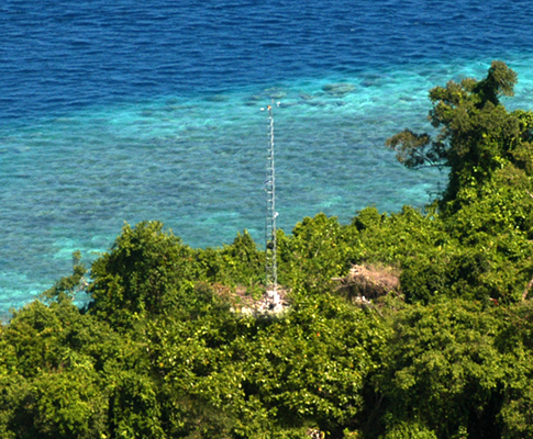
View full image
Image File: http://www.pacioos.hawaii.edu/metadata/browse/aws_crrf.2.png
File Description:
Photo of instrument site.
Descriptive Keywords:
Keywords:
Keyword Type:
theme
(MD_KeywordTypeCode)
Keyword: Earth Science Atmosphere Atmospheric Radiation Shortwave Radiation
Keyword: Earth Science Atmosphere Atmospheric Temperature Surface Temperature Air Temperature
Keyword: Earth Science Atmosphere Atmospheric Water Vapor Humidity
Keyword: Earth Science Atmosphere Atmospheric Winds Surface Winds Wind Speed/Wind Direction
Keyword: Earth Science Atmosphere Precipitation
Keyword: Earth Science Biosphere Vegetation Photosynthetically Active Radiation
Keyword Thesaurus:
Citation Information:
Title:
GCMD Science Keywords
Keywords:
Keyword Type:
theme
(MD_KeywordTypeCode)
Keyword: In Situ Land-based Platforms Weather Stations/Networks Weather Stations
Keyword Thesaurus:
Citation Information:
Title:
GCMD Platform Keywords
Keywords:
Keyword Type:
theme
(MD_KeywordTypeCode)
Keyword: Earth Remote Sensing Instruments Passive Remote Sensing Thermal/Radiation Detectors Pyranometers
Keyword: In Situ/Laboratory Instruments Current/Wind Meters Anemometers
Keyword: In Situ/Laboratory Instruments Gauges Rain Gauges
Keyword: In Situ/Laboratory Instruments Radiation Sensors Licor Quantum Sensor
Keyword: In Situ/Laboratory Instruments Temperature/Humidity Sensors Humidity Sensors
Keyword: In Situ/Laboratory Instruments Temperature/Humidity Sensors Temperature Sensors
Keyword Thesaurus:
Citation Information:
Title:
GCMD Instrument Keywords
Keywords:
Keyword Type:
place
(MD_KeywordTypeCode)
Keyword: Ocean Pacific Ocean Western Pacific Ocean Palau Koror
Keyword: Ocean Pacific Ocean Western Pacific Ocean Palau Mecherchar
Keyword: Ocean Pacific Ocean Western Pacific Ocean Palau Ngeanges
Keyword: Ocean Pacific Ocean Western Pacific Ocean Palau Rock Islands
Keyword Thesaurus:
Citation Information:
Title:
GCMD Location Keywords
Keywords:
Keyword Type:
project
(MD_KeywordTypeCode)
Keyword: PacIOOS Pacific Islands Ocean Observing System
Keyword Thesaurus:
Citation Information:
Title:
GCMD Project Keywords
Keywords:
Keyword Type:
dataCenter
(MD_KeywordTypeCode)
Keyword: PacIOOS Pacific Islands Ocean Observing System
Keyword Thesaurus:
Citation Information:
Title:
GCMD Data Center Keywords
Keywords:
Keyword Type:
theme
(MD_KeywordTypeCode)
Keyword: air_temperature
Keyword: altitude
Keyword: downwelling_shortwave_flux_in_air
Keyword: latitude
Keyword: longitude
Keyword: rainfall_amount
Keyword: relative_humidity
Keyword: surface_downwelling_photosynthetic_photon_flux_in_air
Keyword: time
Keyword: wind_from_direction
Keyword: wind_speed
Keyword: wind_speed_of_gust
Keyword Thesaurus:
Citation Information:
Title:
CF Standard Name Table v71
Aggregation Information:
Aggregate Dataset Name:
Citation Information:
Title:
Pacific Islands Ocean Observing System (PacIOOS)
Association Type: largerWorkCitation (DS_AssociationTypeCode)
Initiative Type: project (DS_InitiativeTypeCode)
Aggregation Information:
Aggregate Dataset Identifier:
Code:
TimeSeries
Authority:
Unidata Common Data Model
Association Type: largerWorkCitation (DS_AssociationTypeCode)
Initiative Type: project (DS_InitiativeTypeCode)
Resource Constraints:
Legal Constraints:
Use Limitation:
The data may be used and redistributed for free but is not intended for legal use, since it may contain inaccuracies. Neither the data Contributor, University of Hawaii, PacIOOS, NOAA, State of Hawaii nor the United States Government, nor any of their employees or contractors, makes any warranty, express or implied, including warranties of merchantability and fitness for a particular purpose, or assumes any legal liability for the accuracy, completeness, or usefulness, of this information.
Language:
eng
Topic Category:
climatologyMeteorologyAtmosphere
Extent Information:
Spatial Temporal Extent:
Geographic Element:
Bounding Coordinates:
Westbound Longitude: 132.371°
Eastbound Longitude: 132.371°
Southbound Latitude: 7.20915°
Northbound Latitude: 7.20915°
Temporal Element:
Time Period:
Begin Position: March 1, 2007
End Position: February 28, 2015
Vertical Element:
Minimum Value: 42.7 m
Maximum Value: 42.7 m
Coordinate Reference System (CRS): missing
Services:
Service Identification:
Identifier: ERDDAP-tabledap
Service Type:
ERDDAP tabledap
Contains Operation:
Operation Name:
ERDDAPtabledapDatasetQueryAndAccess
Online Resource:
Linkage: https://pae-paha.pacioos.hawaii.edu/erddap/tabledap/aws_crrf
Name:
ERDDAP-tabledap
Protocol:
ERDDAP:tabledap
Description:
ERDDAP's tabledap service (a flavor of OPeNDAP) for tabular (sequence) data. Add different extensions (e.g., .html, .graph, .das, .dds) to the base URL for different purposes.
Function:
download
(CI_OnLineFunctionCode)
Services:
Service Identification:
Identifier: OPeNDAP
Service Type:
OPeNDAP
Contains Operation:
Operation Name:
OPeNDAPDatasetQueryAndAccess
Online Resource:
Linkage: https://pae-paha.pacioos.hawaii.edu/erddap/tabledap/aws_crrf
Name:
OPeNDAP
Protocol:
OPeNDAP:OPeNDAP
Description:
An OPeNDAP service for tabular (sequence) data. Add different extensions (e.g., .html, .das, .dds) to the base URL for different purposes.
Function:
download
(CI_OnLineFunctionCode)
Back to Top
