Citation:
Citation Information:
Title:
ETOPO5 Global Surface Relief
Date:
Date: January 1, 1988
Date Type:
creation
(CI_DateTypeCode)
Identifier:
Code:
etopo5
Authority:
org.pacioos
Responsible Party:
Individual Name:
Peter W. Sloss
Organization Name:
NOAA Marine Geology and Geophysics (MGG)
Contact:
Contact Address:
Email:
mgg.info@noaa.gov
Online Resource:
Linkage: https://www.ngdc.noaa.gov/mgg/
Protocol:
http
Function:
information
(CI_OnLineFunctionCode)
Contact Role:
originator
(CI_RoleCode)
Responsible Party:
Organization Name:
Pacific Islands Ocean Observing System (PacIOOS)
Contact:
Contact Address:
Email:
info@pacioos.org
Online Resource:
Linkage: http://pacioos.org
Protocol:
http
Function:
information
(CI_OnLineFunctionCode)
Contact Role:
publisher
(CI_RoleCode)
Suggested data citation: Sloss, P.W. 1988. ETOPO5 Global Surface Relief. Distributed by the Pacific Islands Ocean Observing System (PacIOOS). http://pacioos.org/metadata/etopo5.html. Accessed [date].
Abstract:
ETOPO5 is a 5 arc-minute global relief model of Earth's surface that integrates land topography and ocean bathymetry. It was built from numerous global and regional data sets. This historical dataset has been deprecated in favor of the newer and higher-resolution ETOPO1 1 arc-minute global relief model.
Purpose:
PacIOOS provides timely, reliable, and accurate ocean information to support a safe, clean, productive ocean and resilient coastal zone in the U.S. Pacific Islands region.
Credit:
The Pacific Islands Ocean Observing System (PacIOOS) is funded through the National Oceanic and Atmospheric Administration (NOAA) as a Regional Association within the U.S. Integrated Ocean Observing System (IOOS). PacIOOS is coordinated by the University of Hawaii School of Ocean and Earth Science and Technology (SOEST).
Point of Contact:
Responsible Party:
Individual Name:
Peter W. Sloss
Organization Name:
NOAA Marine Geology and Geophysics (MGG)
Contact:
Contact Address:
Email:
mgg.info@noaa.gov
Online Resource:
Linkage: https://www.ngdc.noaa.gov/mgg/
Protocol:
http
Function:
information
(CI_OnLineFunctionCode)
Contact Role:
pointOfContact
(CI_RoleCode)
Browse Graphic:
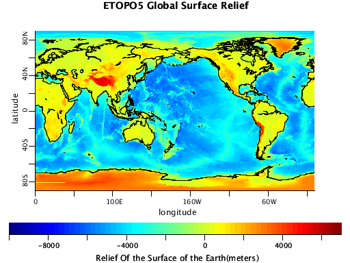
View full image
Image File: http://www.pacioos.hawaii.edu/metadata/browse/etopo5.png
File Description:
Sample image.
Descriptive Keywords:
Keywords:
Keyword Type:
theme
(MD_KeywordTypeCode)
Keyword: Earth Science Land Surface Topography Terrain Elevation Digital Elevation/Terrain Model (DEM)
Keyword: Earth Science Oceans Bathymetry/Seafloor Topography Bathymetry
Keyword Thesaurus:
Citation Information:
Title:
GCMD Science Keywords
Keywords:
Keyword Type:
theme
(MD_KeywordTypeCode)
Keyword: Models/Analyses DEM Digital Elevation Model
Keyword Thesaurus:
Citation Information:
Title:
GCMD Platform Keywords
Keywords:
Keyword Type:
theme
(MD_KeywordTypeCode)
Keyword: Not Applicable Not Applicable
Keyword Thesaurus:
Citation Information:
Title:
GCMD Instrument Keywords
Keywords:
Keyword Type:
place
(MD_KeywordTypeCode)
Keyword: Geographic Region Global
Keyword Thesaurus:
Citation Information:
Title:
GCMD Location Keywords
Keywords:
Keyword Type:
project
(MD_KeywordTypeCode)
Keyword: PacIOOS Pacific Islands Ocean Observing System
Keyword Thesaurus:
Citation Information:
Title:
GCMD Project Keywords
Keywords:
Keyword Type:
dataCenter
(MD_KeywordTypeCode)
Keyword: PacIOOS Pacific Islands Ocean Observing System
Keyword Thesaurus:
Citation Information:
Title:
GCMD Data Center Keywords
Keywords:
Keyword Type:
theme
(MD_KeywordTypeCode)
Keyword: height
Keyword: latitude
Keyword: longitude
Keyword Thesaurus:
Citation Information:
Title:
CF Standard Name Table v39
Aggregation Information:
Aggregate Dataset Name:
Citation Information:
Title:
Pacific Islands Ocean Observing System (PacIOOS)
Association Type: largerWorkCitation (DS_AssociationTypeCode)
Initiative Type: project (DS_InitiativeTypeCode)
Aggregation Information:
Aggregate Dataset Identifier:
Code:
Grid
Authority:
Unidata Common Data Model
Association Type: largerWorkCitation (DS_AssociationTypeCode)
Initiative Type: project (DS_InitiativeTypeCode)
Resource Constraints:
Legal Constraints:
Use Limitation:
The data may be used and redistributed for free but is not intended for legal use, since it may contain inaccuracies. Neither the data Contributor, University of Hawaii, PacIOOS, NOAA, State of Hawaii nor the United States Government, nor any of their employees or contractors, makes any warranty, express or implied, including warranties of merchantability and fitness for a particular purpose, or assumes any legal liability for the accuracy, completeness, or usefulness, of this information.
Language:
eng
Topic Category:
elevation
Topic Category:
oceans
Extent Information:
Spatial Temporal Extent:
Geographic Element:
Bounding Coordinates:
Westbound Longitude: .0°
Eastbound Longitude: 359.92°
Southbound Latitude: -90.0°
Northbound Latitude: 90.0°
Temporal Element:
Time Period:
Begin Position: January 1, 1985
End Position: January 1, 1988
Vertical Element:
Minimum Value:
-10376.0
m
Maximum Value:
7833.0
m
Coordinate Reference System (CRS): missing
Services:
Service Identification:
Identifier: OPeNDAP
Service Type:
THREDDS OPeNDAP
Contains Operation:
Operation Name:
OPeNDAP Client Access
Online Resource:
Linkage: https://pae-paha.pacioos.hawaii.edu/thredds/dodsC/etopo5
Name:
OPeNDAP
Protocol:
OPeNDAP:OPeNDAP
Description:
THREDDS OPeNDAP
Function:
download
(CI_OnLineFunctionCode)
Services:
Service Identification:
Identifier: OGC-WCS
Service Type:
Open Geospatial Consortium Web Coverage Service (WCS)
Contains Operation:
Operation Name:
GetCapabilities
Online Resource:
Linkage: https://pae-paha.pacioos.hawaii.edu/thredds/wcs/etopo5?service=WCS&version=1.0.0&request=GetCapabilities
Name:
OGC-WCS
Protocol:
OGC:WCS
Description:
Open Geospatial Consortium Web Coverage Service (WCS)
Function:
download
(CI_OnLineFunctionCode)
Services:
Service Identification:
Identifier: OGC-WMS
Service Type:
Open Geospatial Consortium Web Map Service (WMS)
Contains Operation:
Operation Name:
GetCapabilities
Online Resource:
Linkage: https://pae-paha.pacioos.hawaii.edu/thredds/wms/etopo5?service=WMS&version=1.3.0&request=GetCapabilities
Name:
OGC-WMS
Protocol:
OGC:WMS
Description:
Open Geospatial Consortium Web Map Service (WMS)
Function:
download
(CI_OnLineFunctionCode)
Services:
Service Identification:
Identifier: THREDDS_NetCDF_Subset
Service Type:
THREDDS NetCDF Subset Service
Contains Operation:
Operation Name:
NetCDFSubsetService
Online Resource:
Linkage: https://pae-paha.pacioos.hawaii.edu/thredds/ncss/etopo5/dataset.html
Name:
THREDDS_NetCDF_Subset
Protocol:
UNIDATA:NCSS
Description:
THREDDS NetCDF Subset Service
Function:
download
(CI_OnLineFunctionCode)
Back to Top
