Dataset Identifier:
hi_dar_bigi_hcrs_cap
Citation:
Citation Information:
Title: Hawaii Coral Reef Strategy (HCRS) Conservation Action Plan (CAP): South Kohala Priority Site
Originator: State of Hawaii Division of Aquatic Resources (DAR)
Publication Date: January 25, 2016
Description:
Abstract:
The State of Hawaii Department of Land and Natural Resources (DLNR) Division of Aquatic Resources (DAR) is the primary agency responsible for coordinating Hawaii's reef management efforts in the main Hawaiian Islands. The Coral Reef Working Group (CRWG), made up of key state and federal partners involved in coral reef management, was established to help provide guidance for the State of Hawaii's coral program.
The 2010 Hawaii Coral Reef Strategy (HCRS) is the guiding coral reef management document used by the DAR with support from the NOAA Coral Reef Conservation Program. The HCRS was developed through a participatory process including DAR staff as well as other agency representatives, academics and NGO partners and regional experts. Prior to the completion of the HCRS, management efforts were informed by threat-focused Local Action Strategies (LAS's). While the HRCS prioritizes place-based stewardship efforts, it includes and incorporates actions and needs identified by the LAS's.
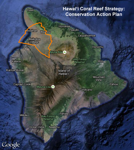
This layer outlines the HCRS project boundary for a portion of the west coast of Hawaii Island (Big Island) in South Kohala. The goal for the South Kohala Conservation Action Plan (CAP) is to develop strategies to address priority threats to South Kohala's coral reef ecosystems. This process will engage statebolders to identify: 1) priority conservation targets, 2) threats acting on the targets, 3) strategies to conserve the targets, and 4) measurable indicators to evaluate the success of those strategies at conserving the targets.
For further information, please see:
http://dlnr.hawaii.gov/coralreefs/reports/
Purpose: PacIOOS provides timely, reliable, and accurate ocean information to support a safe, clean, productive ocean and resilient coastal zone in the U.S. Pacific Islands region.
Spatial Domain:
Bounding Coordinates:
West Bounding Coordinate: -155.95517°
East Bounding Coordinate: -155.60113°
North Bounding Coordinate: 20.11439°
South Bounding Coordinate: 19.76369°
Keywords:
Theme:
Theme Keyword Thesaurus: GCMD Science Keywords
Keyword: Earth Science Human Dimensions Boundaries Administrative Divisions
Keyword: Earth Science Human Dimensions Environmental Governance/Management
Keyword: Earth Science Human Dimensions Environmental Impacts Conservation
Place:
Place Keyword Thesaurus: GCMD Location Keywords
Place Keyword: Continent North America United States Of America Hawaii
Place Keyword: Ocean Pacific Ocean Central Pacific Ocean Hawaiian Islands Big Island
Place Keyword: Ocean Pacific Ocean Central Pacific Ocean Hawaiian Islands Hawaii Island South Kohala
Access Constraints:
None
Use Constraints:
Use Limitation: The data may be used and redistributed for free but is not intended for legal use, since it may contain inaccuracies. Neither the data Contributor, University of Hawaii, PacIOOS, NOAA, State of Hawaii nor the United States Government, nor any of their employees or contractors, makes any warranty, express or implied, including warranties of merchantability and fitness for a particular purpose, or assumes any legal liability for the accuracy, completeness, or usefulness, of this information.
Point of Contact:
Contact Information:
Contact Organization Primary:
Contact Organization: State of Hawaii Division of Aquatic Resources (DAR)
Contact Electronic Mail Address: DLNR.aquatics@hawaii.gov
Data Set Credit:
The Pacific Islands Ocean Observing System (PacIOOS) is funded through the National Oceanic and Atmospheric Administration (NOAA) as a Regional Association within the U.S. Integrated Ocean Observing System (IOOS). PacIOOS is coordinated by the University of Hawaii School of Ocean and Earth Science and Technology (SOEST).
Browse Graphic:
View full image
Browse Graphic File Name: http://www.pacioos.hawaii.edu/metadata/browse/hi_dar_bigi_hcrs_cap.png
Browse Graphic File Description:
Sample image.
Browse Graphic File Type: PNG
Back to Top
