Citation:
Citation Information:
Title:
Habitat Blueprint: West Hawaii Focus Area
Date:
Date: January 25, 2016
Date Type:
creation
(CI_DateTypeCode)
Identifier:
Code:
hi_noaa_bigi_blueprint
Authority:
org.pacioos
Responsible Party:
Organization Name:
NOAA Habitat Blueprint
Contact:
Contact Address:
Email:
lani.watson@noaa.gov
Online Resource:
Linkage: http://www.habitatblueprint.noaa.gov
Protocol:
http
Function:
information
(CI_OnLineFunctionCode)
Contact Role:
originator
(CI_RoleCode)
Responsible Party:
Organization Name:
Pacific Islands Ocean Observing System (PacIOOS)
Contact:
Contact Address:
Email:
info@pacioos.org
Online Resource:
Linkage: http://pacioos.org
Protocol:
http
Function:
information
(CI_OnLineFunctionCode)
Contact Role:
publisher
(CI_RoleCode)
Suggested data citation: NOAA Habitat Blueprint. 2016. Habitat Blueprint: West Hawaii Focus Area. Distributed by the Pacific Islands Ocean Observing System (PacIOOS). http://pacioos.org/metadata/hi_noaa_bigi_blueprint.html. Accessed [date].
Abstract:
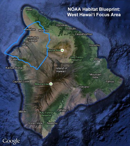
The Habitat Blueprint provides a forward-looking framework for NOAA to think and act strategically across programs and with partner organizations to improve coastal and marine habitats for fisheries, marine life, and coastal communities. This layer outlines the Habitat Blueprint project boundary for a portion of the west coast of Hawaii Island (Big Island).
The leeward (west) side of Big Island is known for white sandy beaches and coral reefs that make it a popular destination for snorkeling, diving, and fishing. The region contains a variety of ecosystems including watersheds, Anchialine pool systems, dry-land forest, and coral reefs. There are several species of concern in the area that are important to Hawaii's economy, culture, and environment. For example, South Kohala contains one of the longest contiguous coral reefs in the state. Nearly a quarter of the corals and fish that live along this coast are found nowhere else in the world. Endangered or threatened species found in this area include Hawaiian monk seals, humpback whales, false killer whales, and green sea turtles (honu). The South Kohala district is one of the fastest growing areas on the Big Island and development is on the rise. Land uses include resort areas and very popular beaches. This means striking a delicate balance between the needs of humans and those of the natural resources. West Hawaii's natural resources are also threatened by land-based pollution and sediment, aquarium fishing, drought, fires, and invasive species.
For further information, please see:
https://www.habitatblueprint.noaa.gov/habitat-focus-areas/west-hawaii/
Purpose:
PacIOOS provides timely, reliable, and accurate ocean information to support a safe, clean, productive ocean and resilient coastal zone in the U.S. Pacific Islands region.
Credit:
The Pacific Islands Ocean Observing System (PacIOOS) is funded through the National Oceanic and Atmospheric Administration (NOAA) as a Regional Association within the U.S. Integrated Ocean Observing System (IOOS). PacIOOS is coordinated by the University of Hawaii School of Ocean and Earth Science and Technology (SOEST).
Point of Contact:
Responsible Party:
Organization Name:
NOAA Habitat Blueprint
Contact:
Contact Address:
Email:
lani.watson@noaa.gov
Online Resource:
Linkage: http://www.habitatblueprint.noaa.gov
Protocol:
http
Function:
information
(CI_OnLineFunctionCode)
Contact Role:
pointOfContact
(CI_RoleCode)
Browse Graphic:
View full image
Image File: http://www.pacioos.hawaii.edu/metadata/browse/hi_noaa_bigi_blueprint.png
File Description:
Sample image.
Descriptive Keywords:
Keywords:
Keyword Type:
theme
(MD_KeywordTypeCode)
Keyword: Earth Science Human Dimensions Boundaries Administrative Divisions
Keyword: Earth Science Human Dimensions Environmental Governance/Management
Keyword: Earth Science Human Dimensions Environmental Impacts Conservation
Keyword Thesaurus:
Citation Information:
Title:
GCMD Science Keywords
Keywords:
Keyword Type:
place
(MD_KeywordTypeCode)
Keyword: Continent North America United States Of America Hawaii
Keyword: Ocean Pacific Ocean Central Pacific Ocean Hawaiian Islands Big Island
Keyword: Ocean Pacific Ocean Central Pacific Ocean Hawaiian Islands Hawaii Island North Kona
Keyword: Ocean Pacific Ocean Central Pacific Ocean Hawaiian Islands Hawaii Island South Kohala
Keyword Thesaurus:
Citation Information:
Title:
GCMD Location Keywords
Keywords:
Keyword Type:
project
(MD_KeywordTypeCode)
Keyword: PacIOOS Pacific Islands Ocean Observing System
Keyword Thesaurus:
Citation Information:
Title:
GCMD Project Keywords
Keywords:
Keyword Type:
dataCenter
(MD_KeywordTypeCode)
Keyword: PacIOOS Pacific Islands Ocean Observing System
Keyword Thesaurus:
Citation Information:
Title:
GCMD Data Center Keywords
Aggregation Information:
Aggregate Dataset Name:
Citation Information:
Title:
Pacific Islands Ocean Observing System (PacIOOS)
Association Type: largerWorkCitation (DS_AssociationTypeCode)
Initiative Type: project (DS_InitiativeTypeCode)
Resource Constraints:
Legal Constraints:
Use Limitation:
The data may be used and redistributed for free but is not intended for legal use, since it may contain inaccuracies. Neither the data Contributor, University of Hawaii, PacIOOS, NOAA, State of Hawaii nor the United States Government, nor any of their employees or contractors, makes any warranty, express or implied, including warranties of merchantability and fitness for a particular purpose, or assumes any legal liability for the accuracy, completeness, or usefulness, of this information.
Language:
eng
Topic Category:
boundaries
Topic Category:
environment
Extent Information:
Spatial Temporal Extent:
Geographic Element:
Bounding Coordinates:
Westbound Longitude: -156.10048°
Eastbound Longitude: -155.60111°
Southbound Latitude: 19.62182°
Northbound Latitude: 20.11419°
Services:
Service Identification:
Identifier: OGC-WFS
Service Type:
Open Geospatial Consortium Web Feature Service (WFS)
Contains Operation:
Operation Name:
GetCapabilities
Online Resource:
Linkage: http://geo.pacioos.hawaii.edu/geoserver/PACIOOS/hi_noaa_bigi_blueprint/ows?service=WFS&version=1.0.0&request=GetCapabilities
Name:
OGC-WFS
Protocol:
OGC:WFS
Description:
Open Geospatial Consortium Web Feature Service (WFS). Supported WFS versions include 1.0.0, 1.1.0, and 2.0.0. Supported output formats include CSV, GeoJSON, GeoJSON-P, GML, KML, and Shapefile (Zipped).
Function:
download
(CI_OnLineFunctionCode)
Services:
Service Identification:
Identifier: OGC-WMS
Service Type:
Open Geospatial Consortium Web Map Service (WMS)
Contains Operation:
Operation Name:
GetCapabilities
Online Resource:
Linkage: http://geo.pacioos.hawaii.edu/geoserver/PACIOOS/hi_noaa_bigi_blueprint/ows?service=WMS&version=1.3.0&request=GetCapabilities
Name:
OGC-WMS
Protocol:
OGC:WMS
Description:
Open Geospatial Consortium Web Map Service (WMS). Supported WMS versions include 1.1.1 and 1.3.0. Supported map formats include AtomPub, GeoRSS, GeoTIFF, GIF, JPEG, KML/KMZ, PDF, PNG, SVG, and TIFF. Supported info formats include GeoJSON, GeoJSON-P, GML, HTML, and plain text.
Function:
download
(CI_OnLineFunctionCode)
Services:
Service Identification:
Identifier: OGC-WMS-C
Service Type:
Open Geospatial Consortium Web Map Service - Cached (WMS-C)
Contains Operation:
Operation Name:
GetCapabilities
Online Resource:
Linkage: http://geo.pacioos.hawaii.edu/geoserver/PACIOOS/gwc/service/wms?service=WMS&version=1.1.1&request=GetCapabilities&tiled=true
Name:
OGC-WMS-C
Protocol:
OGC:WMS-C
Description:
Open Geospatial Consortium Web Map Service - Cached (WMS-C). Use of WMS-C is similar to traditional WMS but with the addition of the "tiled=true" parameter, which triggers GeoServer to pull map tiles from GeoWebCache if they have been previously generated. This can dramatically improve performance, especially for larger datasets. Supported map formats include JPEG and PNG. Supported info formats include GeoJSON, GML, HTML, and plain text.
Function:
download
(CI_OnLineFunctionCode)
Back to Top
