Citation:
Citation Information:
Title:
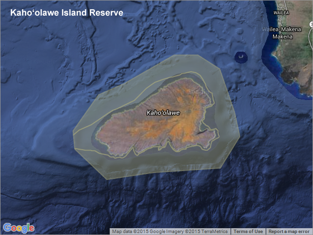
Kahoolawe Island Reserve - Hawaii
Date:
Date: January 25, 2016
Date Type:
creation
(CI_DateTypeCode)
Identifier:
Code:
hi_sohdop_kaho_reserve
Authority:
org.pacioos
Responsible Party:
Organization Name:
Kahoolawe Island Reserve Commission (KIRC)
Contact:
Contact Address:
Email:
administrator@kirc.hawaii.gov
Online Resource:
Linkage: http://www.kahoolawe.hawaii.gov
Protocol:
http
Function:
information
(CI_OnLineFunctionCode)
Contact Role:
resourceProvider
(CI_RoleCode)
Responsible Party:
Organization Name:
Hawaii Statewide GIS Program
Contact:
Contact Address:
Email:
gis@hawaii.gov
Online Resource:
Linkage: http://planning.hawaii.gov/gis/
Protocol:
http
Function:
information
(CI_OnLineFunctionCode)
Contact Role:
resourceProvider
(CI_RoleCode)
Responsible Party:
Organization Name:
Pacific Islands Ocean Observing System (PacIOOS)
Contact:
Contact Address:
Email:
info@pacioos.org
Online Resource:
Linkage: http://pacioos.org
Protocol:
http
Function:
information
(CI_OnLineFunctionCode)
Contact Role:
publisher
(CI_RoleCode)
Suggested data citation: Kahoolawe Island Reserve Commission (KIRC) and Hawaii Statewide GIS Program. 2016. Kahoolawe Island Reserve - Hawaii. Distributed by the Pacific Islands Ocean Observing System (PacIOOS). http://pacioos.org/metadata/hi_sohdop_kaho_reserve.html. Accessed [date].
Abstract:
Boundary of the marine portions of the Kahoolawe Island Reserve for the island of Kahoolawe in Hawaii. Beginning in World War II, Kahoolawe was used as a training ground and bombing range by the U.S. military. After decades of protests, the Navy ended live-fire training in 1990 and the island was transferred to the State of Hawaii in 1994. The state legislature established the Kahoolawe Island Reserve to restore and oversee the island and its surrounding waters. Today, Kahoolawe can be used only for native Hawaiian cultural, spiritual, and subsistence purposes. All entry to the reserve must be authorized by the Kahoolawe Island Reserve Commission.
For more information, please see:
http://www.kahoolawe.hawaii.gov
Purpose:
PacIOOS provides timely, reliable, and accurate ocean information to support a safe, clean, productive ocean and resilient coastal zone in the U.S. Pacific Islands region.
Credit:
The Pacific Islands Ocean Observing System (PacIOOS) is funded through the National Oceanic and Atmospheric Administration (NOAA) as a Regional Association within the U.S. Integrated Ocean Observing System (IOOS). PacIOOS is coordinated by the University of Hawaii School of Ocean and Earth Science and Technology (SOEST).
Point of Contact:
Responsible Party:
Organization Name:
Kahoolawe Island Reserve Commission (KIRC)
Contact:
Contact Address:
Email:
administrator@kirc.hawaii.gov
Online Resource:
Linkage: http://www.kahoolawe.hawaii.gov
Protocol:
http
Function:
information
(CI_OnLineFunctionCode)
Contact Role:
pointOfContact
(CI_RoleCode)
Browse Graphic:
View full image
Image File: http://www.pacioos.hawaii.edu/metadata/browse/hi_sohdop_kaho_reserve.png
File Description:
Sample image.
Descriptive Keywords:
Keywords:
Keyword Type:
theme
(MD_KeywordTypeCode)
Keyword: Earth Science Human Dimensions Boundaries Administrative Divisions
Keyword: Earth Science Human Dimensions Environmental Governance/Management
Keyword: Earth Science Human Dimensions Environmental Impacts Conservation
Keyword Thesaurus:
Citation Information:
Title:
GCMD Science Keywords
Keywords:
Keyword Type:
place
(MD_KeywordTypeCode)
Keyword: Continent North America United States Of America Hawaii
Keyword: Ocean Pacific Ocean Central Pacific Ocean Hawaiian Islands Kahoolawe
Keyword Thesaurus:
Citation Information:
Title:
GCMD Location Keywords
Keywords:
Keyword Type:
project
(MD_KeywordTypeCode)
Keyword: PacIOOS Pacific Islands Ocean Observing System
Keyword Thesaurus:
Citation Information:
Title:
GCMD Project Keywords
Keywords:
Keyword Type:
dataCenter
(MD_KeywordTypeCode)
Keyword: PacIOOS Pacific Islands Ocean Observing System
Keyword Thesaurus:
Citation Information:
Title:
GCMD Data Center Keywords
Aggregation Information:
Aggregate Dataset Name:
Citation Information:
Title:
Pacific Islands Ocean Observing System (PacIOOS)
Association Type: largerWorkCitation (DS_AssociationTypeCode)
Initiative Type: project (DS_InitiativeTypeCode)
Resource Constraints:
Legal Constraints:
Use Limitation:
The data may be used and redistributed for free but is not intended for legal use, since it may contain inaccuracies. Neither the data Contributor, University of Hawaii, PacIOOS, NOAA, State of Hawaii nor the United States Government, nor any of their employees or contractors, makes any warranty, express or implied, including warranties of merchantability and fitness for a particular purpose, or assumes any legal liability for the accuracy, completeness, or usefulness, of this information.
Language:
eng
Topic Category:
boundaries
Topic Category:
environment
Extent Information:
Spatial Temporal Extent:
Geographic Element:
Bounding Coordinates:
Westbound Longitude: -156.73249°
Eastbound Longitude: -156.49749°
Southbound Latitude: 20.46999°
Northbound Latitude: 20.63416°
Services:
Service Identification:
Identifier: OGC-WFS
Service Type:
Open Geospatial Consortium Web Feature Service (WFS)
Contains Operation:
Operation Name:
GetCapabilities
Online Resource:
Linkage: http://geo.pacioos.hawaii.edu/geoserver/PACIOOS/hi_sohdop_kaho_reserve/ows?service=WFS&version=1.0.0&request=GetCapabilities
Name:
OGC-WFS
Protocol:
OGC:WFS
Description:
Open Geospatial Consortium Web Feature Service (WFS). Supported WFS versions include 1.0.0, 1.1.0, and 2.0.0. Supported output formats include CSV, GeoJSON, GeoJSON-P, GML, KML, and Shapefile (Zipped).
Function:
download
(CI_OnLineFunctionCode)
Services:
Service Identification:
Identifier: OGC-WMS
Service Type:
Open Geospatial Consortium Web Map Service (WMS)
Contains Operation:
Operation Name:
GetCapabilities
Online Resource:
Linkage: http://geo.pacioos.hawaii.edu/geoserver/PACIOOS/hi_sohdop_kaho_reserve/ows?service=WMS&version=1.3.0&request=GetCapabilities
Name:
OGC-WMS
Protocol:
OGC:WMS
Description:
Open Geospatial Consortium Web Map Service (WMS). Supported WMS versions include 1.1.1 and 1.3.0. Supported map formats include AtomPub, GeoRSS, GeoTIFF, GIF, JPEG, KML/KMZ, PDF, PNG, SVG, and TIFF. Supported info formats include GeoJSON, GeoJSON-P, GML, HTML, and plain text.
Function:
download
(CI_OnLineFunctionCode)
Services:
Service Identification:
Identifier: OGC-WMS-C
Service Type:
Open Geospatial Consortium Web Map Service - Cached (WMS-C)
Contains Operation:
Operation Name:
GetCapabilities
Online Resource:
Linkage: http://geo.pacioos.hawaii.edu/geoserver/PACIOOS/gwc/service/wms?service=WMS&version=1.1.1&request=GetCapabilities&tiled=true
Name:
OGC-WMS-C
Protocol:
OGC:WMS-C
Description:
Open Geospatial Consortium Web Map Service - Cached (WMS-C). Use of WMS-C is similar to traditional WMS but with the addition of the "tiled=true" parameter, which triggers GeoServer to pull map tiles from GeoWebCache if they have been previously generated. This can dramatically improve performance, especially for larger datasets. Supported map formats include JPEG and PNG. Supported info formats include GeoJSON, GML, HTML, and plain text.
Function:
download
(CI_OnLineFunctionCode)
Back to Top
