Citation:
Citation Information:
Title:
Puako Coral Health And Water Quality Sites - West Hawaii Island, Hawaii
Date:
Date: November 2, 2018
Date Type:
creation
(CI_DateTypeCode)
Identifier:
Code:
hi_tnc_bigi_puako_monitoring
Authority:
org.pacioos
Responsible Party:
Individual Name:
Chad Wiggins
Organization Name:
The Nature Conservancy (TNC) Hawaii
Contact:
Contact Address:
Email:
cwiggins@tnc.org
Contact Role:
originator
(CI_RoleCode)
Responsible Party:
Organization Name:
The Nature Conservancy (TNC) Hawaii
Contact:
Contact Address:
Email:
hawaii@tnc.org
Online Resource:
Linkage: https://www.nature.org/en-us/about-us/where-we-work/united-states/hawaii/
Protocol:
http
Function:
information
(CI_OnLineFunctionCode)
Contact Role:
originator
(CI_RoleCode)
Responsible Party:
Organization Name:
Pacific Islands Ocean Observing System (PacIOOS)
Contact:
Contact Address:
Email:
info@pacioos.org
Online Resource:
Linkage: http://pacioos.org
Protocol:
http
Function:
information
(CI_OnLineFunctionCode)
Contact Role:
publisher
(CI_RoleCode)
Suggested data citation: Wiggins, C. and The Nature Conservancy (TNC) Hawaii. 2018. Puako Coral Health And Water Quality Sites - West Hawaii Island, Hawaii. Distributed by the Pacific Islands Ocean Observing System (PacIOOS). http://pacioos.org/metadata/hi_tnc_bigi_puako_monitoring.html. Accessed [date].
Abstract:
To understand and mitigate the impacts of land-based pollution on coral reef health, The Nature Conservancy (TNC), University of Hawaii at Hilo (UH), and other researchers collected data to: 1) identify where high groundwater flows occur on the Puako reef system; 2) determine what is in the water by monitoring levels of bacteria and nutrients; and 3) assess whether degraded water quality can compromise coral health - and if so, which sites are most vulnerable.
Purpose:
PacIOOS provides timely, reliable, and accurate ocean information to support a safe, clean, productive ocean and resilient coastal zone in the U.S. Pacific Islands region.
Credit:
The Pacific Islands Ocean Observing System (PacIOOS) is funded through the National Oceanic and Atmospheric Administration (NOAA) as a Regional Association within the U.S. Integrated Ocean Observing System (IOOS). PacIOOS is coordinated by the University of Hawaii School of Ocean and Earth Science and Technology (SOEST).
Point of Contact:
Responsible Party:
Individual Name:
Chad Wiggins
Organization Name:
The Nature Conservancy (TNC) Hawaii
Contact:
Contact Address:
Email:
cwiggins@tnc.org
Contact Role:
pointOfContact
(CI_RoleCode)
Browse Graphic:
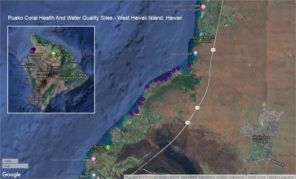
View full image
Image File: http://www.pacioos.hawaii.edu/metadata/browse/hi_tnc_bigi_puako_monitoring.png
File Description:
Sample image.
Descriptive Keywords:
Keywords:
Keyword Type:
theme
(MD_KeywordTypeCode)
Keyword: Earth Science Biological Classification Animals/Vertebrates Fish
Keyword: Earth Science Biosphere Aquatic Ecosystems Reef Habitat
Keyword: Earth Science Human Dimensions Environmental Governance/Management Environmental Assessments
Keyword: Earth Science Oceans Aquatic Sciences Fisheries
Keyword: Earth Science Oceans Coastal Processes Coral Reefs
Keyword: Earth Science Oceans Marine Environment Monitoring
Keyword: Earth Science Oceans Water Quality
Keyword Thesaurus:
Citation Information:
Title:
GCMD Science Keywords
Keywords:
Keyword Type:
place
(MD_KeywordTypeCode)
Keyword: Continent North America United States Of America Hawaii
Keyword: Ocean Pacific Ocean Central Pacific Ocean Hawaiian Islands Big Island
Keyword: Ocean Pacific Ocean Central Pacific Ocean Hawaiian Islands Hawaii Island Mauna Lani
Keyword: Ocean Pacific Ocean Central Pacific Ocean Hawaiian Islands Hawaii Island Puako
Keyword: Ocean Pacific Ocean Central Pacific Ocean Hawaiian Islands Hawaii Island South Kohala
Keyword Thesaurus:
Citation Information:
Title:
GCMD Location Keywords
Keywords:
Keyword Type:
project
(MD_KeywordTypeCode)
Keyword: PacIOOS Pacific Islands Ocean Observing System
Keyword Thesaurus:
Citation Information:
Title:
GCMD Project Keywords
Keywords:
Keyword Type:
dataCenter
(MD_KeywordTypeCode)
Keyword: PacIOOS Pacific Islands Ocean Observing System
Keyword Thesaurus:
Citation Information:
Title:
GCMD Data Center Keywords
Aggregation Information:
Aggregate Dataset Name:
Citation Information:
Title:
Pacific Islands Ocean Observing System (PacIOOS)
Association Type: largerWorkCitation (DS_AssociationTypeCode)
Initiative Type: project (DS_InitiativeTypeCode)
Resource Constraints:
Legal Constraints:
Use Limitation:
The data may be used and redistributed for free but is not intended for legal use, since it may contain inaccuracies. Neither the data Contributor, University of Hawaii, PacIOOS, NOAA, State of Hawaii nor the United States Government, nor any of their employees or contractors, makes any warranty, express or implied, including warranties of merchantability and fitness for a particular purpose, or assumes any legal liability for the accuracy, completeness, or usefulness, of this information.
Language:
eng
Topic Category:
biota
Topic Category:
environment
Topic Category:
oceans
Extent Information:
Spatial Temporal Extent:
Geographic Element:
Bounding Coordinates:
Westbound Longitude: -155.86591°
Eastbound Longitude: -155.83281°
Southbound Latitude: 19.95119°
Northbound Latitude: 19.97718°
Services:
Service Identification:
Identifier: OGC-WFS
Service Type:
Open Geospatial Consortium Web Feature Service (WFS)
Contains Operation:
Operation Name:
GetCapabilities
Online Resource:
Linkage: http://geo.pacioos.hawaii.edu/geoserver/PACIOOS/hi_tnc_bigi_puako_monitoring/ows?service=WFS&version=1.0.0&request=GetCapabilities
Name:
OGC-WFS
Protocol:
OGC:WFS
Description:
Open Geospatial Consortium Web Feature Service (WFS). Supported WFS versions include 1.0.0, 1.1.0, and 2.0.0. Supported output formats include CSV, GeoJSON, GeoJSON-P, GML, KML, and Shapefile (Zipped).
Function:
download
(CI_OnLineFunctionCode)
Services:
Service Identification:
Identifier: OGC-WMS
Service Type:
Open Geospatial Consortium Web Map Service (WMS)
Contains Operation:
Operation Name:
GetCapabilities
Online Resource:
Linkage: http://geo.pacioos.hawaii.edu/geoserver/PACIOOS/hi_tnc_bigi_puako_monitoring/ows?service=WMS&version=1.3.0&request=GetCapabilities
Name:
OGC-WMS
Protocol:
OGC:WMS
Description:
Open Geospatial Consortium Web Map Service (WMS). Supported WMS versions include 1.1.1 and 1.3.0. Supported map formats include AtomPub, GeoRSS, GeoTIFF, GIF, JPEG, KML/KMZ, PDF, PNG, SVG, and TIFF. Supported info formats include GeoJSON, GeoJSON-P, GML, HTML, and plain text.
Function:
download
(CI_OnLineFunctionCode)
Services:
Service Identification:
Identifier: OGC-WMS-C
Service Type:
Open Geospatial Consortium Web Map Service - Cached (WMS-C)
Contains Operation:
Operation Name:
GetCapabilities
Online Resource:
Linkage: http://geo.pacioos.hawaii.edu/geoserver/PACIOOS/gwc/service/wms?service=WMS&version=1.1.1&request=GetCapabilities&tiled=true
Name:
OGC-WMS-C
Protocol:
OGC:WMS-C
Description:
Open Geospatial Consortium Web Map Service - Cached (WMS-C). Use of WMS-C is similar to traditional WMS but with the addition of the "tiled=true" parameter, which triggers GeoServer to pull map tiles from GeoWebCache if they have been previously generated. This can dramatically improve performance, especially for larger datasets. Supported map formats include JPEG and PNG. Supported info formats include GeoJSON, GML, HTML, and plain text.
Function:
download
(CI_OnLineFunctionCode)
Back to Top
