Citation:
Citation Information:
Title:
Surface CUrrents from a Diagnostic model (SCUD): Pacific
Date:
Date: March 17, 2012
Date Type:
creation
(CI_DateTypeCode)
Identifier:
Code:
scud_pac
Authority:
org.pacioos
Responsible Party:
Individual Name:
Nikolai A. Maximenko
Organization Name:
University of Hawaii at Manoa
Contact:
Contact Address:
Email:
maximenk@hawaii.edu
Online Resource:
Linkage: http://iprc.soest.hawaii.edu/people/person.php?username=maximenko
Protocol:
http
Function:
information
(CI_OnLineFunctionCode)
Contact Role:
originator
(CI_RoleCode)
Responsible Party:
Organization Name:
Pacific Islands Ocean Observing System (PacIOOS)
Contact:
Contact Address:
Email:
info@pacioos.org
Online Resource:
Linkage: http://pacioos.org
Protocol:
http
Function:
information
(CI_OnLineFunctionCode)
Contact Role:
publisher
(CI_RoleCode)
Suggested data citation: Maximenko, N.A. 2012. Surface CUrrents from a Diagnostic model (SCUD): Pacific. [Indicate temporal subset used.] Distributed by the Pacific Islands Ocean Observing System (PacIOOS). http://pacioos.org/metadata/scud_pac.html. Accessed [date].
Abstract:
The SCUD data product is an estimate of upper-ocean velocities computed from a diagnostic model (Surface CUrrents from a Diagnostic model). This model makes daily estimates of ocean currents by combining geostrophic and Ekman currents. The estimate is computed through derived coefficients such that the results best match ocean drifting buoys. The currents therefore are a best-estimate of currents at 15 meters (drifting buoys are drogued at 15 meters). The dataset is intended to diagnose trajectories of a tracer floating near the surface such as marine debris, oil spills, etc. The data are provided on a 1/4-degree grid for the Pacific.
Purpose:
PacIOOS provides timely, reliable, and accurate ocean information to support a safe, clean, productive ocean and resilient coastal zone in the U.S. Pacific Islands region.
Credit:
The Pacific Islands Ocean Observing System (PacIOOS) is funded through the National Oceanic and Atmospheric Administration (NOAA) as a Regional Association within the U.S. Integrated Ocean Observing System (IOOS). PacIOOS is coordinated by the University of Hawaii School of Ocean and Earth Science and Technology (SOEST).
Point of Contact:
Responsible Party:
Individual Name:
Nikolai A. Maximenko
Organization Name:
University of Hawaii at Manoa
Contact:
Contact Address:
Email:
maximenk@hawaii.edu
Online Resource:
Linkage: http://iprc.soest.hawaii.edu/people/person.php?username=maximenko
Protocol:
http
Function:
information
(CI_OnLineFunctionCode)
Contact Role:
pointOfContact
(CI_RoleCode)
Browse Graphic:
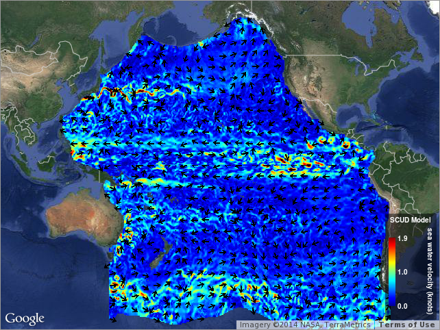
View full image
Image File: http://www.pacioos.hawaii.edu/metadata/browse/scud_pac.png
File Description:
Sample image.
Descriptive Keywords:
Keywords:
Keyword Type:
theme
(MD_KeywordTypeCode)
Keyword: Earth Science Oceans Ocean Circulation Ocean Currents
Keyword: Earth Science Services Models Ocean General Circulation Models (OGCM)/Regional Ocean Models
Keyword: Earth Science Services Models Weather Research/Forecast Models
Keyword Thesaurus:
Citation Information:
Title:
GCMD Science Keywords
Keywords:
Keyword Type:
theme
(MD_KeywordTypeCode)
Keyword: Models/Analyses Operational Models
Keyword Thesaurus:
Citation Information:
Title:
GCMD Platform Keywords
Keywords:
Keyword Type:
theme
(MD_KeywordTypeCode)
Keyword: Not Applicable Not Applicable
Keyword Thesaurus:
Citation Information:
Title:
GCMD Instrument Keywords
Keywords:
Keyword Type:
place
(MD_KeywordTypeCode)
Keyword: Ocean Pacific Ocean
Keyword Thesaurus:
Citation Information:
Title:
GCMD Location Keywords
Keywords:
Keyword Type:
project
(MD_KeywordTypeCode)
Keyword: PacIOOS Pacific Islands Ocean Observing System
Keyword Thesaurus:
Citation Information:
Title:
GCMD Project Keywords
Keywords:
Keyword Type:
dataCenter
(MD_KeywordTypeCode)
Keyword: PacIOOS Pacific Islands Ocean Observing System
Keyword Thesaurus:
Citation Information:
Title:
GCMD Data Center Keywords
Keywords:
Keyword Type:
theme
(MD_KeywordTypeCode)
Keyword: eastward_sea_water_velocity
Keyword: latitude
Keyword: longitude
Keyword: northward_sea_water_velocity
Keyword: time
Keyword Thesaurus:
Citation Information:
Title:
CF Standard Name Table v39
Aggregation Information:
Aggregate Dataset Name:
Citation Information:
Title:
Pacific Islands Ocean Observing System (PacIOOS)
Association Type: largerWorkCitation (DS_AssociationTypeCode)
Initiative Type: project (DS_InitiativeTypeCode)
Aggregation Information:
Aggregate Dataset Identifier:
Code:
Grid
Authority:
Unidata Common Data Model
Association Type: largerWorkCitation (DS_AssociationTypeCode)
Initiative Type: project (DS_InitiativeTypeCode)
Resource Constraints:
Legal Constraints:
Use Limitation:
The data may be used and redistributed for free but is not intended for legal use, since it may contain inaccuracies. Neither the data Contributor, University of Hawaii, PacIOOS, NOAA, State of Hawaii nor the United States Government, nor any of their employees or contractors, makes any warranty, express or implied, including warranties of merchantability and fitness for a particular purpose, or assumes any legal liability for the accuracy, completeness, or usefulness, of this information.
Language:
eng
Topic Category:
oceans
Extent Information:
Spatial Temporal Extent:
Geographic Element:
Bounding Coordinates:
Westbound Longitude: 119.875°
Eastbound Longitude: 291.875°
Southbound Latitude: -70.125°
Northbound Latitude: 61.875°
Temporal Element:
Time Period:
Description: seconds
Begin Position: March 17, 2012
End Position: April 19, 2024
Services:
Service Identification:
Identifier: OPeNDAP
Service Type:
THREDDS OPeNDAP
Contains Operation:
Operation Name:
OPeNDAP Client Access
Online Resource:
Linkage: https://pae-paha.pacioos.hawaii.edu/thredds/dodsC/scud_pac
Name:
OPeNDAP
Protocol:
OPeNDAP:OPeNDAP
Description:
THREDDS OPeNDAP
Function:
download
(CI_OnLineFunctionCode)
Services:
Service Identification:
Identifier: OGC-WCS
Service Type:
Open Geospatial Consortium Web Coverage Service (WCS)
Contains Operation:
Operation Name:
GetCapabilities
Online Resource:
Linkage: https://pae-paha.pacioos.hawaii.edu/thredds/wcs/scud_pac?service=WCS&version=1.0.0&request=GetCapabilities
Name:
OGC-WCS
Protocol:
OGC:WCS
Description:
Open Geospatial Consortium Web Coverage Service (WCS)
Function:
download
(CI_OnLineFunctionCode)
Services:
Service Identification:
Identifier: OGC-WMS
Service Type:
Open Geospatial Consortium Web Map Service (WMS)
Contains Operation:
Operation Name:
GetCapabilities
Online Resource:
Linkage: https://pae-paha.pacioos.hawaii.edu/thredds/wms/scud_pac?service=WMS&version=1.3.0&request=GetCapabilities
Name:
OGC-WMS
Protocol:
OGC:WMS
Description:
Open Geospatial Consortium Web Map Service (WMS)
Function:
download
(CI_OnLineFunctionCode)
Services:
Service Identification:
Identifier: THREDDS_NetCDF_Subset
Service Type:
THREDDS NetCDF Subset Service
Contains Operation:
Operation Name:
NetCDFSubsetService
Online Resource:
Linkage: https://pae-paha.pacioos.hawaii.edu/thredds/ncss/scud_pac/dataset.html
Name:
THREDDS_NetCDF_Subset
Protocol:
UNIDATA:NCSS
Description:
THREDDS NetCDF Subset Service
Function:
download
(CI_OnLineFunctionCode)
Back to Top
