

New Online Tool for West Maui Predicts High Wave Flooding
New Online Tool for West Maui Predicts High Wave Flooding
Posted June 2, 2021West Maui community members, property owners, businesses, as well as state and county officials now have a novel tool at their disposal to predict coastal flooding for the upcoming six days. PacIOOS developed a high resolution, real-time Wave Run-up Forecast for the West Maui shoreline to help increase preparedness and coastal resiliency. The forecast tool can be found at: http://pacioos.org/west-maui
West Maui’s shoreline has experienced an increase in wave plus tide-driven flooding in recent years, and these events are expected to grow in numbers and duration due to sea level rise and changing wave energies. Chronic coastal erosion is leading to severe damage of properties and the associated land-based sediment impairs the nearshore water quality. Wave overtopping and flooding also pose a major safety concern to infrastructure, in particular to Honoapiʻilani Highway, the only access point to West Maui.
West Maui – A special case
“West Maui has an extremely complex nearshore environment. Waves, currents, and water levels are influenced by the highly variable ocean floor, which ranges from deep ocean channels to shallow plateaus. This dynamic environment can lead to significant, yet unexpected, wave run-up and coastal flooding”, says co-investigator Dr. Douglas Luther, Department of Oceanography at the University of Hawaiʻi School of Ocean and Earth Science and Technology (SOEST). “The areas of impact and the severity of impact are not only a function of wave height, wave direction, and tides. Our modeling efforts capture all the physical drivers that contribute to wave run-up, allowing us to shed light on this intricate interplay.”
On June 1 and 8, the project team offered informational presentations via Zoom to introduce the new tool and answer questions. Watch the recording of the online session.

With sea level rise, an increase in wave plus tide-driven flooding has led to worsening coastal erosion in the Honokōwai area of West Maui in recent years. Credit: Don McLeish.
Volunteer citizen scientists contribute valuable photo documentation
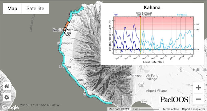
To account for the complexity and differences along the West Maui shoreline, the team divided the shoreline into 12 regions. Each region, from Pāpalaua Wayside Park in the South to Lipoa Point in the North, has its own unique forecast that provides a six-day outlook of potential wave run-up.
With the dedicated support of volunteer citizen scientists, photo documentation has been collected in recent years to capture wave run-up and flooding events at various sites along the West Maui coastline. This database of photos is a key element for the project to better understand on-the-ground vulnerabilities. It also allowed the project team to establish region-specific thresholds, distinguishing between “light impacts”, “hazardous impacts”, and “critical impacts.”
Tara Owens, University of Hawaiʻi Sea Grant College Program and co-investigator for this project, says, “With the concentration of impacts in West Maui already, I am really pleased that the community now has a tool at hand that gives advance notice of potential flooding and run-up impacts. Knowing what to expect now and in the future will allow us to be proactive in our approaches to prepare and mitigate.” The forecast will continue to evolve over time as more wave run-up events occur and additional photo documentation becomes available. “It’s a work in progress, and we are looking forward to continuing to partner with the community to collect photos of wave run-up impacts to help fine tune the model,” Tara adds.
If you would like to get involved and help improve the forecast by collecting photo documentation of wave run-up events along the West Maui coastline, please visit us at http://www.pacioos.org/shoreline-category/runup-westmaui/#about.

Wave run-up and worsening coastal erosion cause impacts to shoreline vegetation, coastal properties, and nearshore water quality at Nāpili Bay. Credit: Brenda Jarmakani.
Funding and community support
The forecast was developed by PacIOOS in close collaboration with UH SOEST, Hawaiʻi Sea Grant, the County of Maui, and the State of Hawaiʻi Department of Land and Natural Resources. The project was made possible through funding from NOAA’s Regional Coastal Resilience Grants Program. Additional funding was provided by the Joint Institute for Marine and Atmospheric Research (JIMAR), Hawaiʻi Sea Grant, and PacIOOS along with in-kind support from Ultimate Whale Watch, Sands of Kahana of Soleil Management, and the University of Hawaiʻi Maui College.


