

Insular Pacific Shallow-Water Benthic Habitats
Insular Pacific Shallow-Water Benthic Habitats
Posted June 4, 2013To supplement the main Hawaiian islands, Voyager’s “benthic habitats” category now contains NOAA shallow-water benthic habitat maps for other PacIOOS regions throughout the insular Pacific, including islands in American Samoa, the Commonwealth of the Northern Mariana Islands (CNMI), Guam, and Palau.
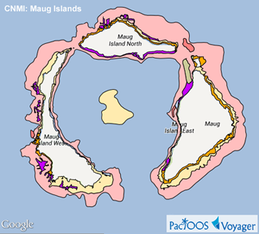
Example Voyager screenshots of benthic biological cover types (view legend):
 |
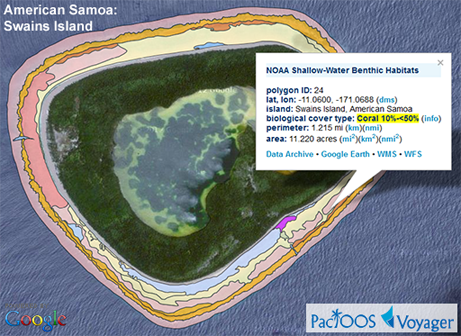 |
NOAA’s National Centers for Coastal Ocean Science (NCCOS) produced these maps to support coral reef research and management. Their classification scheme defines benthic habitats on the basis of three attributes: large geographic “zones” which are comprised of smaller geomorphological structures and biological cover types of the reef system. These were digitally identified using visual interpretation of orthorectified satellite imagery. Click here for futher details.
While benthic overlays were previously provided through Voyager via Keyhole Markup Language (KML), these large data sets exceed memory limitations in Version 3 of the Google Maps API. As a workaround, benthic habitat maps are now rendered as image overlays. Polygons are still clickable and produce pop-up windows with further information. Overlay opacity is now adjustable. However, for performance reasons we can no longer provide distinct habitat types into individually selectable layers (e.g. Coral 10-50%): all habitat types for a given category (biology, geomorphology, geography) are displayed at once.
On the upside, PacIOOS has generated a Web Map Service (WMS) and Web Feature Service (WFS) from the NOAA/NCCOS Shapefiles. These interoperable Open Geospatial Consortium (OGC) standards will help users who may want to incorporate data and map imagery of these layers into other mapping applications: WMS GetCapabilities • WFS GetCapabilities.
In the future, we hope to supplement these benthic maps with those from the Northwestern Hawaiian Islands (NWHI) (provided here). Because NOAA used a different classification system in the NWHI, however, some small adjustments will be necessary.
For further information, please visit:


