Dataset Identifier:
roms_samoa_assim
Citation:
Citation Information:
Title: Regional Ocean Modeling System (ROMS): Samoa: Data Assimilating
Originator: Brian S. Powell
Publication Date: February 11, 2014
Description:
Abstract:
Regional Ocean Modeling System (ROMS) 3-day, 3-hourly data assimilating hindcast for the region surrounding the islands of Samoa at approximately 3-km resolution. Boundary conditions provided by the global, 1/12-degree (~9-km) HYbrid Coordinate Ocean Model (HYCOM). Atmospheric forcing generated by the Weather Research and Forecasting (WRF) model for the region surrounding the islands of Samoa (wrf_samoa) at approximately 3-km resolution. Tide forcing uses the Oregon State University (OSU) Tidal Prediction Software (OTPS) TOPEX/Poseidon global inverse solution (TPXO) to derive barotropic tidal elevation and velocity. Data are assimilated over the previous 3 days using all available observations to improve the model estimate of current ocean state (its nowcast). Assimilated observations may include satellite-based sea surface temperatures from MODIS, AVHRR, or OSTIA; satellite-based sea surface height from AVISO; and in-situ water temperature and salinity profiles from ARGO floats. While considerable effort has been made to implement all model components in a thorough, correct, and accurate manner, numerous sources of error are possible. As such, please use these data with the caution appropriate for any ocean related activity.
Purpose: PacIOOS provides timely, reliable, and accurate ocean information to support a safe, clean, productive ocean and resilient coastal zone in the U.S. Pacific Islands region.
Time Period of Content:
Time Period Information:
Range of Dates/Times:
Beginning Date: April 12, 2015
Ending Date: May 12, 2025
Currentness Reference: Unknown
Spatial Domain:
Bounding Coordinates:
West Bounding Coordinate: -174.0°
East Bounding Coordinate: -168.80878°
North Bounding Coordinate: -12.49855°
South Bounding Coordinate: -15.5°
Bounding Altitudes:
Altitude Minimum: -0.25
Altitude Maximum: -5500
Altitude Distance Units:
m
Keywords:
Theme:
Theme Keyword Thesaurus: GCMD Science Keywords
Keyword: Earth Science Oceans Ocean Circulation Ocean Currents
Keyword: Earth Science Oceans Ocean Temperature Potential Temperature
Keyword: Earth Science Oceans Salinity/Density Salinity
Keyword: Earth Science Oceans Sea Surface Topography Sea Surface Height
Keyword: Earth Science Services Models Ocean General Circulation Models (OGCM)/Regional Ocean Models
Keyword: Earth Science Services Models Weather Research/Forecast Models
Theme:
Theme Keyword Thesaurus: GCMD Platform Keywords
Keyword: Models/Analyses Operational Models
Theme:
Theme Keyword Thesaurus: GCMD Instrument Keywords
Keyword: Not Applicable Not Applicable
Theme:
Theme Keyword Thesaurus: CF Standard Name Table v39
Keyword: depth
Keyword: eastward_sea_water_velocity
Keyword: forecast_period
Keyword: forecast_reference_time
Keyword: latitude
Keyword: longitude
Keyword: northward_sea_water_velocity
Keyword: sea_binary_mask
Keyword: sea_surface_height
Keyword: sea_water_potential_temperature
Keyword: sea_water_salinity
Keyword: time
Place:
Place Keyword Thesaurus: GCMD Location Keywords
Place Keyword: Ocean Pacific Ocean South Pacific Ocean Polynesia American Samoa
Place Keyword: Ocean Pacific Ocean South Pacific Ocean Polynesia Samoa
Access Constraints:
None
Use Constraints:
Use Limitation: The data may be used and redistributed for free but is not intended for legal use, since it may contain inaccuracies. Neither the data Contributor, University of Hawaii, PacIOOS, NOAA, State of Hawaii nor the United States Government, nor any of their employees or contractors, makes any warranty, express or implied, including warranties of merchantability and fitness for a particular purpose, or assumes any legal liability for the accuracy, completeness, or usefulness, of this information.
Point of Contact:
Contact Information:
Contact Organization Primary:
Contact Organization: University of Hawaii at Manoa
Contact Person: Brian S. Powell
Contact Electronic Mail Address: powellb@hawaii.edu
Data Set Credit:
The Pacific Islands Ocean Observing System (PacIOOS) is funded through the National Oceanic and Atmospheric Administration (NOAA) as a Regional Association within the U.S. Integrated Ocean Observing System (IOOS). PacIOOS is coordinated by the University of Hawaii School of Ocean and Earth Science and Technology (SOEST).
Browse Graphic:
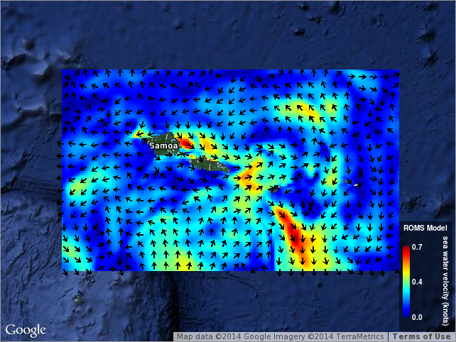
View full image
Browse Graphic File Name: http://www.pacioos.hawaii.edu/metadata/browse/roms_samoa_assim.png
Browse Graphic File Description:
Sample image.
Browse Graphic File Type: PNG
Back to Top
