Dataset Identifier:
swan_maui
Citation:
Citation Information:
Title: Simulating WAves Nearshore (SWAN) Regional Wave Model: Maui
Originator: Kwok Fai Cheung
Publication Date: June 29, 2010
Description:
Abstract:
Simulating WAves Nearshore (SWAN) regional wave model 7-day output with a 5-day hourly forecast for the Hawaiian islands of Maui County (Maui, Molokai, Lanai, and Kahoolawe) at approximately 500-m resolution. This high-resolution model is utilized to capture shallow water effects and nearshore coastal dynamics such as refracting, shoaling, and smaller scale shadowing. It is run directly after the Hawaii regional WaveWatch III (WW3) wave model (ww3_hawaii) has completed. Please note that some of the nested model setup is still in the testing and validation phase. While considerable effort has been made to implement all model components in a thorough, correct, and accurate manner, numerous sources of error are possible. As such, please use these data with the caution appropriate for any ocean related activity.
Purpose: PacIOOS provides timely, reliable, and accurate ocean information to support a safe, clean, productive ocean and resilient coastal zone in the U.S. Pacific Islands region.
Time Period of Content:
Time Period Information:
Range of Dates/Times:
Beginning Date: January 5, 2016
Ending Date: April 23, 2024
Currentness Reference: Unknown
Spatial Domain:
Bounding Coordinates:
West Bounding Coordinate: 202.60001°
East Bounding Coordinate: 204.10001°
North Bounding Coordinate: 21.3°
South Bounding Coordinate: 20.4°
Bounding Altitudes:
Altitude Minimum: 0.0
Altitude Maximum: 0.0
Altitude Distance Units:
m
Keywords:
Theme:
Theme Keyword Thesaurus: GCMD Science Keywords
Keyword: Earth Science Oceans Ocean Waves Significant Wave Height
Keyword: Earth Science Oceans Ocean Waves Wave Period
Keyword: Earth Science Oceans Ocean Waves Wave Speed/Direction
Keyword: Earth Science Services Models Ocean General Circulation Models (OGCM)/Regional Ocean Models
Keyword: Earth Science Services Models Weather Research/Forecast Models
Theme:
Theme Keyword Thesaurus: GCMD Platform Keywords
Keyword: Models/Analyses Operational Models
Theme:
Theme Keyword Thesaurus: GCMD Instrument Keywords
Keyword: Not Applicable Not Applicable
Theme:
Theme Keyword Thesaurus: CF Standard Name Table v39
Keyword: depth
Keyword: forecast_period
Keyword: forecast_reference_time
Keyword: latitude
Keyword: longitude
Keyword: sea_surface_wave_from_direction
Keyword: sea_surface_wave_mean_period_from_variance_spectral_density_second_frequency_moment
Keyword: sea_surface_wave_period_at_variance_spectral_density_maximum
Keyword: sea_surface_wave_significant_height
Keyword: time
Place:
Place Keyword Thesaurus: GCMD Location Keywords
Place Keyword: Continent North America United States Of America Hawaii
Place Keyword: Ocean Pacific Ocean Central Pacific Ocean Hawaiian Islands Kahoolawe
Place Keyword: Ocean Pacific Ocean Central Pacific Ocean Hawaiian Islands Lanai
Place Keyword: Ocean Pacific Ocean Central Pacific Ocean Hawaiian Islands Maui
Place Keyword: Ocean Pacific Ocean Central Pacific Ocean Hawaiian Islands Molokai
Access Constraints:
None
Use Constraints:
Use Limitation: The data may be used and redistributed for free but is not intended for legal use, since it may contain inaccuracies. Neither the data Contributor, University of Hawaii, PacIOOS, NOAA, State of Hawaii nor the United States Government, nor any of their employees or contractors, makes any warranty, express or implied, including warranties of merchantability and fitness for a particular purpose, or assumes any legal liability for the accuracy, completeness, or usefulness, of this information.
Point of Contact:
Contact Information:
Contact Organization Primary:
Contact Organization: University of Hawaii at Manoa
Contact Person: Kwok Fai Cheung
Contact Electronic Mail Address: cheung@hawaii.edu
Data Set Credit:
The Pacific Islands Ocean Observing System (PacIOOS) is funded through the National Oceanic and Atmospheric Administration (NOAA) as a Regional Association within the U.S. Integrated Ocean Observing System (IOOS). PacIOOS is coordinated by the University of Hawaii School of Ocean and Earth Science and Technology (SOEST).
Browse Graphic:
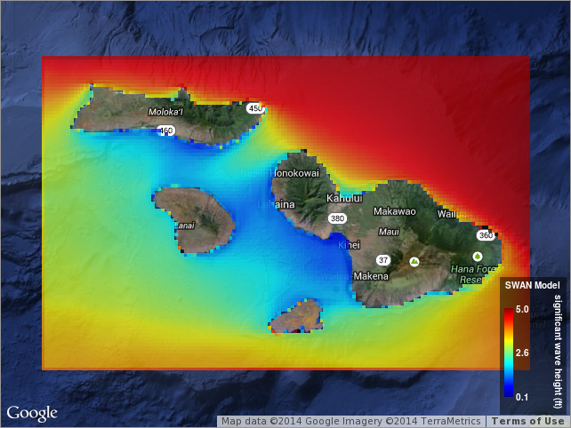
View full image
Browse Graphic File Name: http://www.pacioos.hawaii.edu/metadata/browse/swan_maui.png
Browse Graphic File Description:
Sample image.
Browse Graphic File Type: PNG
Back to Top
