

New Bathymetry And Enhancements
New Bathymetry And Enhancements
Posted September 29, 2015Voyager screenshot of NOAA/NGDC bathymetry (ocean depth) for Tutuila, American Samoa with white 500-ft depth contour, black coastline, and USGS land elevation shaded in green:

In addition to the Main Hawaiian Islands, Voyager now provides 55 additional bathymetry data sets. These digital elevation models (DEMs) of the ocean bottom provide measurements of ocean depth and can be found in Voyager’s “seafloor” category. Compiled from ship-borne multibeam sonar surveys with or without satellite-derived nearshore bathymetry, these include a global 1-km DEM (SRTM30+ v11) as well as the following data available in PacIOOS-supported regions, listed by spatial resolution and data source* (if you know of others, please contact PacIOOS):
American Samoa:
- American Samoa: 90-m (NGDC)
- Northeast Bank: 20-m and 5-m (PIBHMC)
- Ofu and Olosega: 5-m (PIBHMC)
- Rose Atoll: 40-m and 5-m (PIBHMC)
- Swains: 40-m and 10-m (PIBHMC)
- Taʻu: 5-m (PIBHMC)
- Tutuila: 10-m (NGDC) and 5-m (PIBHMC)
- Two Percent Bank: 40-m (PIBHMC)
- Vailuluʻu: 40-m (PIBHMC)
Commonwealth of the Northern Mariana Islands (CNMI):
- Marianas: 180-m (NGDC)
- Agrihan: 10-m and 2-m (PIBHMC)
- Alamagan: 10-m and 5-m (PIBHMC)
- Asuncion: 10-m and 5-m (PIBHMC)
- Farallón de Medinilla: 5-m (PIBHMC)
- Farallón de Pájaros: 10-m (PIBHMC)
- Guguan: 10-m (PIBHMC)
- Marpi Bank: 5-m (PIBHMC)
- Maug Islands: 10-m and 5-m (PIBHMC)
- Pagan: 10-m (PIBHMC)
- Rota: 60-m and 5-m (PIBHMC)
- Saipan: 5-m (PIBHMC)
- Sarigan: 10-m (PIBHMC)
- Supply Reef: 10-m (PIBHMC)
- Tinian: 5-m (PIBHMC)
Guam:
- Guam: 10-m (NGDC) and 5-m (PIBHMC)
- Apra Harbor: 1-m (PIBHMC)
Hawaiʻi:
- Main Hawaiian Islands: 50-m (HMRG)
- Northwestern Hawaiian Islands: 60-m (HURL)
Republic of the Marshall Islands (RMI):
- Majuro: Eastern Reef: 50-m (SOPAC)
- Majuro: Lagoon: 5-m (SOPAC)
U.S. Minor Outlying Islands (USMOI):
- Baker Island: 40-m and 5-m (PIBHMC)
- Howland Island: 40-m and 5-m (PIBHMC)
- Jarvis Island: 20-m and 5-m (PIBHMC)
- Johnston Atoll: 20-m and 5-m (PIBHMC)
- Kingman Reef: 20-m and 5-m (PIBHMC)
- Palmyra Atoll: 40-m and 5-m (PIBHMC)
- Wake Island: 10-m (NGDC)
*Data sources include the following:
- Hawaiʻi Mapping Research Group (HMRG) (UH/SOEST)
- Hawaiʻi Undersea Research Laboratory (HURL) (UH/SOEST)
- National Oceanic and Atmospheric Administration (NOAA) National Geophysical Data Center (NGDC)
- Pacific Islands Benthic Habitat Mapping Center (PIBHMC) (NOAA/CRED and UH/SOEST)
- Secretariat of the Pacific Community (SPC) Applied Geoscience and Technology Division (SOPAC)
These updates also build on Voyager’s recently added DEM utilities for improved elevation mapping, including custom color shading, hillshades (topographic relief maps), and contour lines (isolines), which can be arbitrarily combined or viewed separately and provide a wealth of display options seldom found in online mapping sites. By applying shadowing effects, hillshades add depth perception to enhance the three-dimensional (3-D) aspect of the data. Contours are available in both 100 foot and 100 meter increments. Up to five contours can be turned on at once, displayed as either thin or thick lines in black, white, or color. As with many other map overlays in Voyager, clicking the overlay produces a pop-up window with the data value (ocean depth) at the clicked location in a variety of units as well as various data access options.
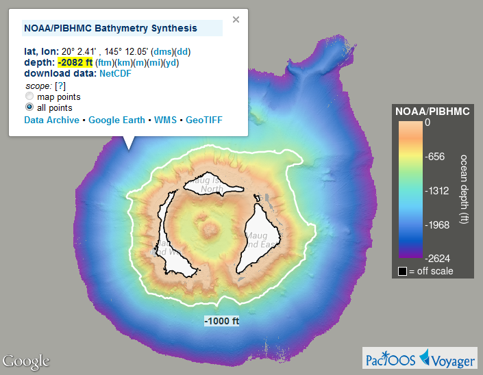
Voyager screenshot of Maug Islands (CNMI) bathymetry with white 1000-ft depth contour and black coastlines:
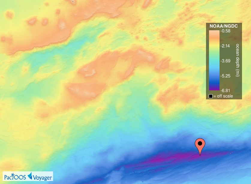
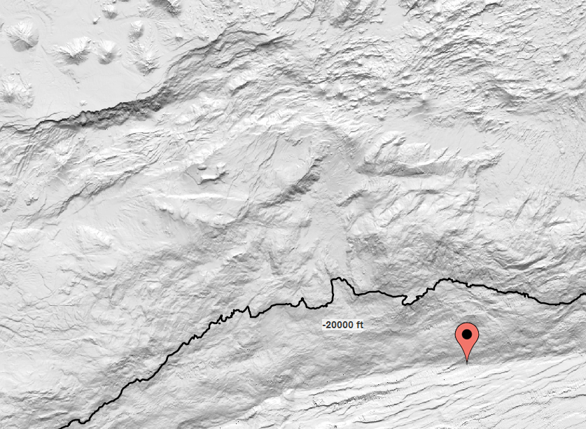
Voyager screenshot of Mariana Trench bathymetry with marker at Challenger Deep, the deepest spot on Earth with a depth of 10,898 to 10,916 m (35,755 to 35,814 ft) and located about 300 km (190 mi) southwest of Guam:
a.) color-shaded:
b.) grayscale hillshade with black 20,000-ft depth contour:
Voyager screenshot of American Samoa bathymetry with color-coded depth contours at 1,000 feet (orange), 5,000 feet (green), 10,000 feet (light blue), and 12,000 feet (dark blue):

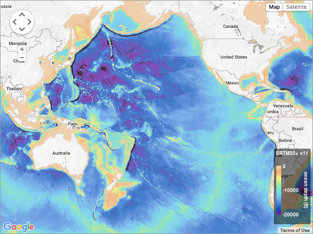
Voyager screenshot of global 1-km resolution SRTM30+ bathymetry:
These data sets have all been added to the PacIOOS data servers. These servers enable standardized, interoperable, remote access mechanisms like Web Map Service (WMS) and OPeNDAP that Voyager leverages to incorporate, visualize, and redistribute these data to our users. Additionally, they will soon also be viewable in Voyager Mobile.


