Citation:
Citation Information:
Title:
Backyard Buoy: Majuro, RMI
Date:
Date: March 31, 2025
Date Type:
creation
(CI_DateTypeCode)
Identifier:
Code:
backyardbuoys_majuro
Authority:
org.backyardbuoys
Responsible Party:
Individual Name:
Dua Rudolph
Organization Name:
Marshall Islands Conservation Society (MICS)
Contact:
Contact Address:
Email:
dua@atollconservation.org
Online Resource:
Linkage: https://www.atollconservation.org
Protocol:
http
Function:
information
(CI_OnLineFunctionCode)
Contact Role:
originator
(CI_RoleCode)
Responsible Party:
Organization Name:
Backyard Buoys
Contact:
Contact Address:
Email:
aplsoftwaresysadmins@uw.edu
Online Resource:
Linkage: https://backyardbuoys.org
Protocol:
http
Function:
information
(CI_OnLineFunctionCode)
Contact Role:
publisher
(CI_RoleCode)
Suggested data citation: Rudolph, D. 2025. Backyard Buoy: Majuro, RMI. [Indicate temporal subset used.] Distributed by the Backyard Buoys. http://pacioos.org/metadata/backyardbuoys_majuro.html. Accessed [date].
Abstract:
Surface wave and water conditions, collected as part of the Backyard Buoys program. This Sofar Spotter buoy is located within the lagoon of Majuro Atoll, approximately 700 meters from Calalin Island at the northern entrance into the lagoon.
Purpose:
The Backyard Buoys program enables Indigenous and coastal communities to gather and use wave data, enhancing their blue economy and hazard protection. Leveraging low-cost and scalable marine technology, Backyard Buoys offers a system for community-managed ocean buoys and web apps that simplify data access to complement Indigenous Knowledge.
Credit:
Funded by the National Science Foundation (NSF) Convergence Accelerator Program, Backyard Buoys is a partnership of Indigenous communities, the Sofar Ocean sensor company, and regional ocean observing systems within the U.S. Integrated Ocean Observing System (IOOS), including the Alaska Ocean Observing System (AOOS), the Northwest Association of Networked Ocean Observing Systems (NANOOS), and the Pacific Islands Ocean Observing System (PacIOOS).
Point of Contact:
Responsible Party:
Individual Name:
Dua Rudolph
Organization Name:
Marshall Islands Conservation Society (MICS)
Contact:
Contact Address:
Email:
dua@atollconservation.org
Online Resource:
Linkage: https://www.atollconservation.org
Protocol:
http
Function:
information
(CI_OnLineFunctionCode)
Contact Role:
pointOfContact
(CI_RoleCode)
Browse Graphic:
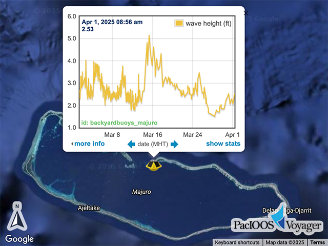
View full image
Image File: http://www.pacioos.hawaii.edu/metadata/browse/backyardbuoys_majuro.png
File Description:
Sample image.
Descriptive Keywords:
Keywords:
Keyword Type:
theme
(MD_KeywordTypeCode)
Keyword: Earth Science Oceans Ocean Temperature Sea Surface Temperature
Keyword: Earth Science Oceans Ocean Waves Significant Wave Height
Keyword: Earth Science Oceans Ocean Waves Wave Period
Keyword: Earth Science Oceans Ocean Waves Wave Speed/Direction
Keyword Thesaurus:
Citation Information:
Title:
GCMD Science Keywords
Keywords:
Keyword Type:
theme
(MD_KeywordTypeCode)
Keyword: In Situ Ocean-based Platforms Buoys
Keyword: In Situ Ocean-based Platforms Moorings
Keyword Thesaurus:
Citation Information:
Title:
GCMD Platform Keywords
Keywords:
Keyword Type:
theme
(MD_KeywordTypeCode)
Keyword: Earth Remote Sensing Instruments Passive Remote Sensing Positioning/Navigation GPS GPS/IMU
Keyword: In Situ/Laboratory Instruments Recorders/Loggers IMU
Keyword: In Situ/Laboratory Instruments Temperature/Humidity Sensors Temperature Sensors
Keyword Thesaurus:
Citation Information:
Title:
GCMD Instrument Keywords
Keywords:
Keyword Type:
place
(MD_KeywordTypeCode)
Keyword: Ocean Pacific Ocean Western Pacific Ocean Micronesia Marshall Islands Majuro
Keyword: Ocean Pacific Ocean Western Pacific Ocean Micronesia Marshall Islands Republic of the Marshall Islands (RMI)
Keyword Thesaurus:
Citation Information:
Title:
GCMD Location Keywords
Keywords:
Keyword Type:
project
(MD_KeywordTypeCode)
Keyword: Backyard Buoys
Keyword Thesaurus: unknown
Keywords:
Keyword Type:
project
(MD_KeywordTypeCode)
Keyword: PacIOOS Pacific Islands Ocean Observing System
Keyword Thesaurus:
Citation Information:
Title:
GCMD Project Keywords
Keywords:
Keyword Type:
dataCenter
(MD_KeywordTypeCode)
Keyword: NANOOS Northwest Association of Networked Ocean Observing Systems
Keyword Thesaurus:
Citation Information:
Title:
GCMD Data Center Keywords
Keywords:
Keyword Type:
theme
(MD_KeywordTypeCode)
Keyword: aggregate_quality_flag
Keyword: flat_line_test_quality_flag
Keyword: gross_range_test_quality_flag
Keyword: latitude
Keyword: longitude
Keyword: rate_of_change_test_quality_flag
Keyword: sea_surface_temperature
Keyword: sea_surface_wave_directional_spread
Keyword: sea_surface_wave_directional_spread_at_variance_spectral_density_maximum
Keyword: sea_surface_wave_from_direction
Keyword: sea_surface_wave_from_direction_at_variance_spectral_density_maximum
Keyword: sea_surface_wave_mean_period
Keyword: sea_surface_wave_period_at_variance_spectral_density_maximum
Keyword: sea_surface_wave_significant_height
Keyword: spike_test_quality_flag
Keyword: time
Keyword Thesaurus:
Citation Information:
Title:
CF Standard Name Table v85
Aggregation Information:
Aggregate Dataset Name:
Citation Information:
Title:
Backyard Buoys
Association Type: largerWorkCitation (DS_AssociationTypeCode)
Initiative Type: project (DS_InitiativeTypeCode)
Aggregation Information:
Aggregate Dataset Identifier:
Code:
TimeSeries
Authority:
Unidata Common Data Model
Association Type: largerWorkCitation (DS_AssociationTypeCode)
Initiative Type: project (DS_InitiativeTypeCode)
Resource Constraints:
Legal Constraints:
Use Limitation:
https://creativecommons.org/licenses/by-nc/4.0/deed.en
Language:
eng
Topic Category:
oceans
Extent Information:
Spatial Temporal Extent:
Geographic Element:
Bounding Coordinates:
Westbound Longitude: 171.20168°
Eastbound Longitude: 171.20229°
Southbound Latitude: 7.15095°
Northbound Latitude: 7.15167°
Temporal Element:
Time Period:
Description: seconds
Begin Position: November 3, 2024
End Position: now
Services:
Service Identification:
Identifier: ERDDAP-tabledap
Service Type:
ERDDAP tabledap
Contains Operation:
Operation Name:
ERDDAPtabledapDatasetQueryAndAccess
Online Resource:
Linkage: https://erddap.backyardbuoys.org/erddap/tabledap/backyardbuoys_majuro
Name:
ERDDAP-tabledap
Protocol:
ERDDAP:tabledap
Description:
ERDDAP's tabledap service (a flavor of OPeNDAP) for tabular (sequence) data. Add different extensions (e.g., .html, .graph, .das, .dds) to the base URL for different purposes.
Function:
download
(CI_OnLineFunctionCode)
Services:
Service Identification:
Identifier: OPeNDAP
Service Type:
OPeNDAP
Contains Operation:
Operation Name:
OPeNDAPDatasetQueryAndAccess
Online Resource:
Linkage: https://erddap.backyardbuoys.org/erddap/tabledap/backyardbuoys_majuro
Name:
OPeNDAP
Protocol:
OPeNDAP:OPeNDAP
Description:
An OPeNDAP service for tabular (sequence) data. Add different extensions (e.g., .html, .das, .dds) to the base URL for different purposes.
Function:
download
(CI_OnLineFunctionCode)
Back to Top
