Citation:
Citation Information:
Title:
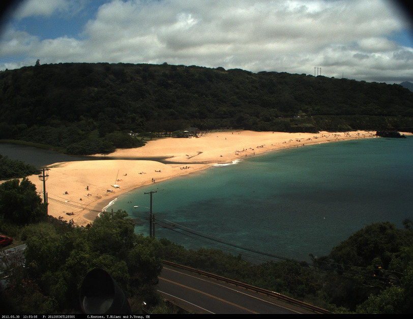
PacIOOS Beach Camera 003: Waimea Bay, Oahu, Hawaii
Date:
Date: February 6, 2009
Date Type:
creation
(CI_DateTypeCode)
Identifier:
Code:
beachcam_003
Authority:
org.pacioos
Responsible Party:
Individual Name: Mark A. Merrifield
Organization Name: Scripps Institution of Oceanography (SIO)
Contact:
Contact Address:
Email:
mamerrifield@ucsd.edu
Online Resource:
Linkage: https://scripps.ucsd.edu/profiles/mamerrifield
Protocol:
http
Function:
information
(CI_OnLineFunctionCode)
Contact Role:
originator
(CI_RoleCode)
Responsible Party:
Organization Name: Pacific Islands Ocean Observing System (PacIOOS)
Contact:
Contact Address:
Email:
info@pacioos.org
Online Resource:
Linkage: http://pacioos.org
Protocol:
http
Function:
information
(CI_OnLineFunctionCode)
Contact Role:
publisher
(CI_RoleCode)
Suggested data citation: Merrifield, M.A. 2009. PacIOOS Beach Camera 003: Waimea Bay, Oahu, Hawaii. [Indicate temporal subset used.] Distributed by the Pacific Islands Ocean Observing System (PacIOOS). http://pacioos.org/metadata/beachcam_003.html. Accessed [date].
Abstract:
A digital camera mounted inside the bell tower of the Mission of Sts. Peter and Paul church was used to photograph the shoreline of Waimea Bay beach park on the North Shore of the island of Oahu in the State of Hawaii. The oblique camera view presented here captures the entire breadth of the beach park looking outwards over Kamehameha Highway towards the southwest. It operated for over 4.5 years between February 5, 2009 and October 14, 2013. Capturing hourly snapshots at a set vantage point during the local daytime hours of 6:00 AM or 7:00 AM to 5:00 PM, these images are useful for tracking beach dynamics such as wave run-up, sand movement, turbidity plumes, and Waimea River outflow over time. The camera was mounted in the bell tower windows for a total height of 20 meters above ground level or 31 meters above mean sea level. See also beachcam_004 for an alternate camera view from the same location pointing further offshore inside of Waimea Bay.
Purpose:
PacIOOS provides timely, reliable, and accurate ocean information to support a safe, clean, productive ocean and resilient coastal zone in the U.S. Pacific Islands region.
Credit:
The Pacific Islands Ocean Observing System (PacIOOS) is funded through the National Oceanic and Atmospheric Administration (NOAA) as a Regional Association within the U.S. Integrated Ocean Observing System (IOOS). PacIOOS is coordinated by the University of Hawaii School of Ocean and Earth Science and Technology (SOEST).
Point of Contact:
Responsible Party:
Individual Name: Mark A. Merrifield
Organization Name: Scripps Institution of Oceanography (SIO)
Contact:
Contact Address:
Email:
mamerrifield@ucsd.edu
Online Resource:
Linkage: https://scripps.ucsd.edu/profiles/mamerrifield
Protocol:
http
Function:
information
(CI_OnLineFunctionCode)
Contact Role:
pointOfContact
(CI_RoleCode)
Browse Graphic:
View full image
Image File: http://www.pacioos.hawaii.edu/metadata/browse/beachcam_003.png
File Description:
Sample image.
Descriptive Keywords:
Keywords:
Keyword Type:
theme
(MD_KeywordTypeCode)
Keyword: Earth Science Spectral/Engineering Visible Wavelengths Visible Imagery
Keyword Thesaurus:
Citation Information:
Title:
GCMD Science Keywords
Keywords:
Keyword Type:
theme
(MD_KeywordTypeCode)
Keyword: In Situ Land-based Platforms
Keyword Thesaurus:
Citation Information:
Title:
GCMD Platform Keywords
Keywords:
Keyword Type:
theme
(MD_KeywordTypeCode)
Keyword: Earth Remote Sensing Instruments Passive Remote Sensing Photon/Optical Detectors Cameras
Keyword Thesaurus:
Citation Information:
Title:
GCMD Instrument Keywords
Keywords:
Keyword Type:
place
(MD_KeywordTypeCode)
Keyword: Continent North America United States Of America Hawaii
Keyword: Ocean Pacific Ocean Central Pacific Ocean Hawaiian Islands Oahu North Shore
Keyword: Ocean Pacific Ocean Central Pacific Ocean Hawaiian Islands Oahu Waimea Bay
Keyword Thesaurus:
Citation Information:
Title:
GCMD Location Keywords
Keywords:
Keyword Type:
project
(MD_KeywordTypeCode)
Keyword: PacIOOS Pacific Islands Ocean Observing System
Keyword Thesaurus:
Citation Information:
Title:
GCMD Project Keywords
Keywords:
Keyword Type:
dataCenter
(MD_KeywordTypeCode)
Keyword: PacIOOS Pacific Islands Ocean Observing System
Keyword Thesaurus:
Citation Information:
Title:
GCMD Data Center Keywords
Keywords:
Keyword Type:
theme
(MD_KeywordTypeCode)
Keyword: altitude
Keyword: height
Keyword: latitude
Keyword: longitude
Keyword: time
Keyword Thesaurus:
Citation Information:
Title:
CF Standard Name Table v71
Aggregation Information:
Aggregate Dataset Name:
Citation Information:
Title:
Pacific Islands Ocean Observing System (PacIOOS)
Association Type: largerWorkCitation (DS_AssociationTypeCode)
Initiative Type: project (DS_InitiativeTypeCode)
Aggregation Information:
Aggregate Dataset Identifier:
Code:
TimeSeries
Authority:
Unidata Common Data Model
Association Type: largerWorkCitation (DS_AssociationTypeCode)
Initiative Type: project (DS_InitiativeTypeCode)
Resource Constraints:
Legal Constraints:
Use Limitation:
The data may be used and redistributed for free but is not intended for legal use, since it may contain inaccuracies. Neither the data Contributor, University of Hawaii, PacIOOS, NOAA, State of Hawaii nor the United States Government, nor any of their employees or contractors, makes any warranty, express or implied, including warranties of merchantability and fitness for a particular purpose, or assumes any legal liability for the accuracy, completeness, or usefulness, of this information.
Language:
eng
Topic Category:
imageryBaseMapsEarthCover
Topic Category:
oceans
Extent Information:
Spatial Temporal Extent:
Geographic Element:
Bounding Coordinates:
Westbound Longitude: -158.0634°
Eastbound Longitude: -158.0634°
Southbound Latitude: 21.64358°
Northbound Latitude: 21.64358°
Temporal Element:
Time Period:
Begin Position: February 6, 2009
End Position: October 15, 2013
Vertical Element:
Minimum Value: 31.1 m
Maximum Value: 31.1 m
Coordinate Reference System (CRS): missing
Services:
Service Identification:
Identifier: ERDDAP-tabledap
Service Type:
ERDDAP tabledap
Contains Operation:
Operation Name:
ERDDAPtabledapDatasetQueryAndAccess
Online Resource:
Linkage: https://pae-paha.pacioos.hawaii.edu/erddap/tabledap/beachcam_003
Name:
ERDDAP-tabledap
Protocol:
ERDDAP:tabledap
Description:
ERDDAP's tabledap service (a flavor of OPeNDAP) for tabular (sequence) data. Add different extensions (e.g., .html, .graph, .das, .dds) to the base URL for different purposes.
Function:
download
(CI_OnLineFunctionCode)
Services:
Service Identification:
Identifier: OPeNDAP
Service Type:
OPeNDAP
Contains Operation:
Operation Name:
OPeNDAPDatasetQueryAndAccess
Online Resource:
Linkage: https://pae-paha.pacioos.hawaii.edu/erddap/tabledap/beachcam_003
Name:
OPeNDAP
Protocol:
OPeNDAP:OPeNDAP
Description:
An OPeNDAP service for tabular (sequence) data. Add different extensions (e.g., .html, .das, .dds) to the base URL for different purposes.
Function:
download
(CI_OnLineFunctionCode)
Back to Top
