Citation:
Citation Information:
Title:
PacIOOS Wave Buoy 106: Waimea Bay, Oahu, Hawaii
Date:
Date: December 16, 2001
Date Type:
creation
(CI_DateTypeCode)
Identifier:
Code:
cdip_106
Authority:
org.pacioos
Responsible Party:
Organization Name:
Coastal Data Information Program (CDIP)
Contact:
Contact Address:
Email:
www@cdip.ucsd.edu
Online Resource:
Linkage: http://cdip.ucsd.edu
Protocol:
http
Function:
information
(CI_OnLineFunctionCode)
Contact Role:
originator
(CI_RoleCode)
Responsible Party:
Individual Name:
Margaret A. McManus
Organization Name:
University of Hawaii at Manoa
Contact:
Contact Address:
Email:
mamc@hawaii.edu
Online Resource:
Linkage: http://www.soest.hawaii.edu/oceanography/faculty/mcmanus.html
Protocol:
http
Function:
information
(CI_OnLineFunctionCode)
Contact Role:
originator
(CI_RoleCode)
Responsible Party:
Individual Name:
Mark A. Merrifield
Organization Name:
Scripps Institution of Oceanography (SIO)
Contact:
Contact Address:
Email:
mamerrifield@ucsd.edu
Online Resource:
Linkage: http://scripps.ucsd.edu/profiles/mamerrifield
Protocol:
http
Function:
information
(CI_OnLineFunctionCode)
Contact Role:
originator
(CI_RoleCode)
Responsible Party:
Organization Name:
Pacific Islands Ocean Observing System (PacIOOS)
Contact:
Contact Address:
Email:
info@pacioos.org
Online Resource:
Linkage: http://pacioos.org
Protocol:
http
Function:
information
(CI_OnLineFunctionCode)
Contact Role:
resourceProvider
(CI_RoleCode)
Responsible Party:
Organization Name:
Coastal Data Information Program (CDIP)
Contact:
Contact Address:
Email:
www@cdip.ucsd.edu
Online Resource:
Linkage: http://cdip.ucsd.edu
Protocol:
http
Function:
information
(CI_OnLineFunctionCode)
Contact Role:
publisher
(CI_RoleCode)
Suggested data citation: Coastal Data Information Program (CDIP), M.A. McManus, M.A. Merrifield, and Pacific Islands Ocean Observing System (PacIOOS). 2001. PacIOOS Wave Buoy 106: Waimea Bay, Oahu, Hawaii. [Indicate temporal subset used.] Distributed by the Coastal Data Information Program (CDIP). http://pacioos.org/metadata/cdip_106.html. Accessed [date].
Abstract:
Wave buoy 106 measures wave height, wave direction, wave period, and water temperature in the vicinity of Waimea Bay on the North Shore of Oahu in the State of Hawaii. Data are transmitted every half hour. Moored in water 200 meters deep, this Datawell Directional Waverider Mark III (DWR-MkIII) buoy is equipped with three accelerometers measuring north/south, east/west, and vertical displacements, allowing it to measure both wave direction and wave energy. The temperature sensor is located at the base of the 0.9 meter spherical buoy, approximately 45 cm or 18 inches below the ocean surface. Wave buoys are useful tools for forecasting local waves and are used by recreational and professional ocean users alike.
Purpose:
PacIOOS provides timely, reliable, and accurate ocean information to support a safe, clean, productive ocean and resilient coastal zone in the U.S. Pacific Islands region.
Credit:
The Pacific Islands Ocean Observing System (PacIOOS) is funded through the National Oceanic and Atmospheric Administration (NOAA) as a Regional Association within the U.S. Integrated Ocean Observing System (IOOS). PacIOOS is coordinated by the University of Hawaii School of Ocean and Earth Science and Technology (SOEST). Wave buoy 106 is owned and managed by PacIOOS. The Office of Naval Research provided the initial funding to purchase this buoy while the U.S. Army Corps of Engineers (USACE) provides funding for ongoing maintenance. Data are managed and distributed by the Coastal Data Information Program (CDIP).
Point of Contact:
Responsible Party:
Organization Name:
Coastal Data Information Program (CDIP)
Contact:
Contact Address:
Email:
www@cdip.ucsd.edu
Online Resource:
Linkage: http://cdip.ucsd.edu
Protocol:
http
Function:
information
(CI_OnLineFunctionCode)
Contact Role:
pointOfContact
(CI_RoleCode)
Browse Graphic:
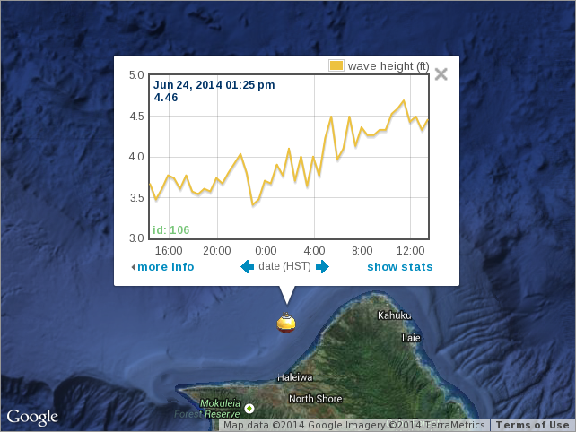
View full image
Image File: http://www.pacioos.hawaii.edu/metadata/browse/cdip_106.png
File Description:
Sample image.
Browse Graphic:
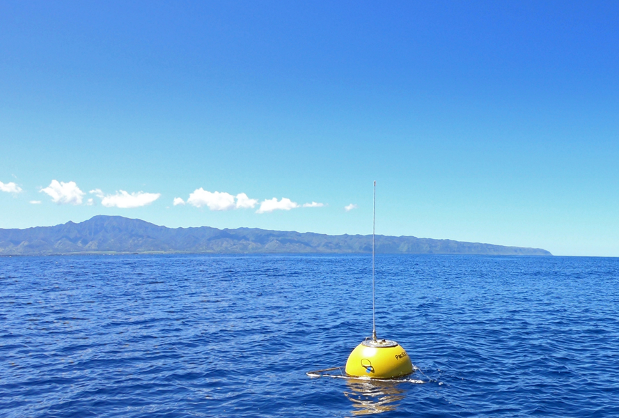
View full image
Image File: http://www.pacioos.hawaii.edu/metadata/browse/cdip_106.2.png
File Description:
Photo of instrument site. Credit: PacIOOS/Joe Gilmore.
Descriptive Keywords:
Keywords:
Keyword Type:
theme
(MD_KeywordTypeCode)
Keyword: Earth Science Oceans Ocean Temperature Water Temperature
Keyword: Earth Science Oceans Ocean Waves Significant Wave Height
Keyword: Earth Science Oceans Ocean Waves Wave Period
Keyword: Earth Science Oceans Ocean Waves Wave Speed/Direction
Keyword Thesaurus:
Citation Information:
Title:
GCMD Science Keywords
Keywords:
Keyword Type:
theme
(MD_KeywordTypeCode)
Keyword: In Situ Ocean-based Platforms Buoys
Keyword: In Situ Ocean-based Platforms Moorings
Keyword Thesaurus:
Citation Information:
Title:
GCMD Platform Keywords
Keywords:
Keyword Type:
theme
(MD_KeywordTypeCode)
Keyword: In Situ/Laboratory Instruments Magnetic/Motion Sensors Accelerometers Accelerometers
Keyword: In Situ/Laboratory Instruments Temperature/Humidity Sensors Temperature Sensors
Keyword Thesaurus:
Citation Information:
Title:
GCMD Instrument Keywords
Keywords:
Keyword Type:
place
(MD_KeywordTypeCode)
Keyword: Continent North America United States Of America Hawaii
Keyword: Ocean Pacific Ocean Central Pacific Ocean Hawaiian Islands Oahu North Shore
Keyword: Ocean Pacific Ocean Central Pacific Ocean Hawaiian Islands Oahu Waimea Bay
Keyword Thesaurus:
Citation Information:
Title:
GCMD Location Keywords
Keywords:
Keyword Type:
project
(MD_KeywordTypeCode)
Keyword: PacIOOS Pacific Islands Ocean Observing System
Keyword Thesaurus:
Citation Information:
Title:
GCMD Project Keywords
Keywords:
Keyword Type:
dataCenter
(MD_KeywordTypeCode)
Keyword: PacIOOS Pacific Islands Ocean Observing System
Keyword Thesaurus:
Citation Information:
Title:
GCMD Data Center Keywords
Keywords:
Keyword Type:
theme
(MD_KeywordTypeCode)
Keyword: latitude
Keyword: longitude
Keyword: sea_surface_wave_from_direction
Keyword: sea_surface_wave_mean_period_from_variance_spectral_density_second_frequency_moment
Keyword: sea_surface_wave_period_at_variance_spectral_density_maximum
Keyword: sea_surface_wave_significant_height
Keyword: sea_water_temperature
Keyword: time
Keyword Thesaurus:
Citation Information:
Title:
CF Standard Name Table v39
Aggregation Information:
Aggregate Dataset Name:
Citation Information:
Title:
Pacific Islands Ocean Observing System (PacIOOS)
Association Type: largerWorkCitation (DS_AssociationTypeCode)
Initiative Type: project (DS_InitiativeTypeCode)
Resource Constraints:
Legal Constraints:
Use Limitation:
The data may be used and redistributed for free but is not intended for legal use, since it may contain inaccuracies. Neither the data Contributor, University of Hawaii, PacIOOS, NOAA, State of Hawaii nor the United States Government, nor any of their employees or contractors, makes any warranty, express or implied, including warranties of merchantability and fitness for a particular purpose, or assumes any legal liability for the accuracy, completeness, or usefulness, of this information.
Language:
eng
Topic Category:
oceans
Extent Information:
Spatial Temporal Extent:
Geographic Element:
Bounding Coordinates:
Westbound Longitude: -158.1171°
Eastbound Longitude: -158.1171°
Southbound Latitude: 21.6705°
Northbound Latitude: 21.6705°
Temporal Element:
Time Period:
Begin Position: December 16, 2001
End Position: now
Back to Top
