Dataset Identifier:
dist2coast_1deg_land
Citation:
Citation Information:
Title: Distance to Nearest Coastline: 0.01-Degree Grid: Land
Originator: NASA Ocean Biology Processing Group (OBPG)
Originator: Richard P. Stumpf
Publication Date: July 12, 2012
Description:
Abstract:
A global data set of land distances from the nearest coastline. NASA's Ocean Biology Processing Group (OBPG) generated this data set using the Generic Mapping Tools (GMT) software package. Distances were computed with GMT using its intermediate-resolution coastline and then gridded globally at a spatial resolution of 0.04 degrees. Bilinear interpolation was then applied to increase the spatial resolution to 0.01 degrees. There is an uncertainty of up to 1 km in the computed distance at any given point.
Purpose: PacIOOS provides timely, reliable, and accurate ocean information to support a safe, clean, productive ocean and resilient coastal zone in the U.S. Pacific Islands region.
Time Period of Content:
Time Period Information:
Range of Dates/Times:
Beginning Date: June 1, 2009
Ending Date: June 1, 2009
Currentness Reference: Unknown
Spatial Domain:
Bounding Coordinates:
West Bounding Coordinate: -180.0°
East Bounding Coordinate: 179.99001°
North Bounding Coordinate: 90.0°
South Bounding Coordinate: -89.99°
Bounding Altitudes:
Altitude Minimum: 0.0
Altitude Maximum: 0.0
Altitude Distance Units:
m
Keywords:
Theme:
Theme Keyword Thesaurus: GCMD Science Keywords
Keyword: Earth Science Oceans Coastal Process Shorelines
Theme:
Theme Keyword Thesaurus: GCMD Platform Keywords
Keyword: Models/Analyses Data Analysis
Theme:
Theme Keyword Thesaurus: GCMD Instrument Keywords
Keyword: Not Applicable Not Applicable
Theme:
Theme Keyword Thesaurus: CF Standard Name Table v39
Keyword: latitude
Keyword: longitude
Place:
Place Keyword Thesaurus: GCMD Location Keywords
Place Keyword: Geographic Region Global
Access Constraints:
None
Use Constraints:
Use Limitation: The data may be used and redistributed for free but is not intended for legal use, since it may contain inaccuracies. Neither the data Contributor, University of Hawaii, PacIOOS, NOAA, State of Hawaii nor the United States Government, nor any of their employees or contractors, makes any warranty, express or implied, including warranties of merchantability and fitness for a particular purpose, or assumes any legal liability for the accuracy, completeness, or usefulness, of this information.
Point of Contact:
Contact Information:
Contact Organization Primary:
Contact Organization: NASA Ocean Biology Processing Group (OBPG)
Contact Address:
Address Type: physical and mailing
Address:
Unknown
City: Unknown
State or Province: Unknown
Postal Code: Unknown
Data Set Credit:
The Pacific Islands Ocean Observing System (PacIOOS) is funded through the National Oceanic and Atmospheric Administration (NOAA) as a Regional Association within the U.S. Integrated Ocean Observing System (IOOS). PacIOOS is coordinated by the University of Hawaii School of Ocean and Earth Science and Technology (SOEST).
Browse Graphic:
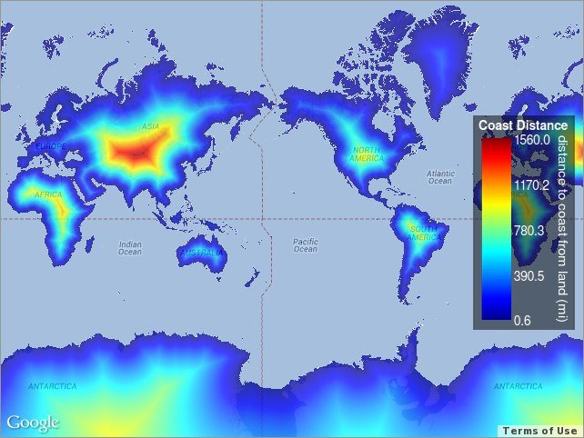
View full image
Browse Graphic File Name: http://www.pacioos.hawaii.edu/metadata/browse/dist2coast_1deg_land.png
Browse Graphic File Description:
Sample image.
Browse Graphic File Type: PNG
Back to Top
