Dataset Identifier:
hi_dar_all_fads
Citation:
Citation Information:
Title: Fish Aggregation Devices (FADs) - Hawaii
Originator: State of Hawaii Division of Aquatic Resources (DAR)
Publication Date: January 25, 2016
Description:
Abstract:
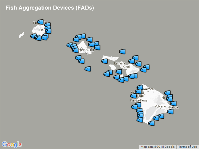
Location of fish aggregation device (FAD) buoys within the Main Hawaiian Islands.
Fishermen in Hawaii and other parts of the world have long known that tunas and other pelagic fishes are attracted to floating objects. Fishermen have benefited from this behavior by fishing around floating logs, nets, debris and other flotsam. Hawaii has capitalized on this phenomena by placing FADs in the waters surrounding the Hawaiian Islands. In these waters, schools of tunas and other important pelagic fishes such as dolphin-fish (mahi-mahi), wahoo (ono), and billfishes can be induced to congregate and remain for periods of time in an area so that fishers can easily locate them. Thus, the FADs are used to "attract" and "hold" pelagic fishes in areas to enhance fishing.
NOTE: Please do not rely on these buoys to check your position. Most buoys have only been located to the nearest 0.1 minute (6 seconds). In addition, each buoy has a watch circle that can be as much as 1 mile in diameter.
Purpose: PacIOOS provides timely, reliable, and accurate ocean information to support a safe, clean, productive ocean and resilient coastal zone in the U.S. Pacific Islands region.
Spatial Domain:
Bounding Coordinates:
West Bounding Coordinate: -159.73166°
East Bounding Coordinate: -154.77833°
North Bounding Coordinate: 22.33°
South Bounding Coordinate: 18.95583°
Keywords:
Theme:
Theme Keyword Thesaurus: GCMD Science Keywords
Keyword: Earth Science Biological Classification Animals/Vertebrates Fish
Keyword: Earth Science Human Dimensions Social Behavior Recreational Activities/Areas Fishing
Keyword: Earth Science Oceans Aquatic Sciences Fisheries
Place:
Place Keyword Thesaurus: GCMD Location Keywords
Place Keyword: Continent North America United States Of America Hawaii
Place Keyword: Ocean Pacific Ocean Central Pacific Ocean Hawaiian Islands
Access Constraints:
None
Use Constraints:
Use Limitation: The data may be used and redistributed for free but is not intended for legal use, since it may contain inaccuracies. Neither the data Contributor, University of Hawaii, PacIOOS, NOAA, State of Hawaii nor the United States Government, nor any of their employees or contractors, makes any warranty, express or implied, including warranties of merchantability and fitness for a particular purpose, or assumes any legal liability for the accuracy, completeness, or usefulness, of this information.
Point of Contact:
Contact Information:
Contact Organization Primary:
Contact Organization: State of Hawaii Division of Aquatic Resources (DAR)
Contact Electronic Mail Address: DLNR.aquatics@hawaii.gov
Data Set Credit:
The Pacific Islands Ocean Observing System (PacIOOS) is funded through the National Oceanic and Atmospheric Administration (NOAA) as a Regional Association within the U.S. Integrated Ocean Observing System (IOOS). PacIOOS is coordinated by the University of Hawaii School of Ocean and Earth Science and Technology (SOEST).
Browse Graphic:
View full image
Browse Graphic File Name: http://www.pacioos.hawaii.edu/metadata/browse/hi_dar_all_fads.png
Browse Graphic File Description:
Sample image.
Browse Graphic File Type: PNG
Back to Top
