Dataset Identifier:
hi_ef_all_coralreefs_plob
Citation:
Citation Information:
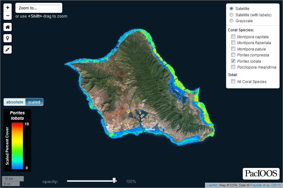
Title: Predicted Coral Cover of Porites lobata in the Hawaiian Islands
Originator: Eric C. Franklin
Originator: Paul L. Jokiel
Originator: Megan J. Donahue
Publication Date: September 26, 2014
Description:
Abstract:
Output from a model to predict the benthic cover of Porites lobata in the Hawaiian Islands as a proportion (0-1.0). Coral cover was modeled with boosted regression trees (BRT) in R software using data from coral cover surveys and environmental covariates derived from models and/or observations including wave height, benthic geomorphology, and downwelled irradiance. The best performing BRT model was used to predict P. lobata cover for the entire geographic study domain. Data and model output represent conditions for shallow coral reefs in the Hawaiian Islands from 0 m to -30 m depth over the time period 2000-2009. Further details on methodology and results are contained in Franklin et al. (2013).
Purpose: PacIOOS provides timely, reliable, and accurate ocean information to support a safe, clean, productive ocean and resilient coastal zone in the U.S. Pacific Islands region.
Spatial Domain:
Bounding Coordinates:
West Bounding Coordinate: -160.27°
East Bounding Coordinate: -154.8°
North Bounding Coordinate: 22.3005°
South Bounding Coordinate: 18.88°
Keywords:
Theme:
Theme Keyword Thesaurus: GCMD Science Keywords
Keyword: Earth Science Biological Classification Animals/Invertebrates Cnidarians
Keyword: Earth Science Biological Classification Animals/Invertebrates Cnidarians Anthozoans/Hexacorals Hard or Stony Corals Porites lobata
Keyword: Earth Science Biological Classification Animals/Invertebrates Cnidarians Anthozoans/Hexacorals Porites lobata
Keyword: Earth Science Biological Classification Animals/Invertebrates Cnidarians Anthozoans/Hexacorals
Keyword: Earth Science Biological Classification Animals/Invertebrates Cnidarians Anthozoans/Hexacorals Hard or Stony Corals
Keyword: Earth Science Oceans Coastal Processes Coral Reefs
Keyword: Earth Science Solid Earth Geomorphic Landforms/Processes Coastal Landforms Coral Reefs
Keyword: Earth Science Solid Earth Geomorphic Landforms/Processes Coastal Landforms Coral Reefs Fringing Reef
Place:
Place Keyword Thesaurus: GCMD Location Keywords
Place Keyword: Continent North America United States of America Hawaii
Place Keyword: Ocean Pacific Ocean Central Pacific Ocean Hawaiian Islands
Access Constraints:
None
Use Constraints:
Use Limitation: The data may be used and redistributed for free but is not intended for legal use, since it may contain inaccuracies. Neither the data Contributor, University of Hawaii, PacIOOS, NOAA, State of Hawaii nor the United States Government, nor any of their employees or contractors, makes any warranty, express or implied, including warranties of merchantability and fitness for a particular purpose, or assumes any legal liability for the accuracy, completeness, or usefulness, of this information.
Point of Contact:
Contact Information:
Contact Organization Primary:
Contact Organization: Hawaii Institute of Marine Biology (HIMB)
Contact Person: Eric C. Franklin
Contact Electronic Mail Address: eric.franklin@hawaii.edu
Data Set Credit:
The Pacific Islands Ocean Observing System (PacIOOS) is funded through the National Oceanic and Atmospheric Administration (NOAA) as a Regional Association within the U.S. Integrated Ocean Observing System (IOOS). PacIOOS is coordinated by the University of Hawaii School of Ocean and Earth Science and Technology (SOEST).
Browse Graphic:
View full image
Browse Graphic File Name: http://www.pacioos.hawaii.edu/metadata/browse/hi_ef_all_coralreefs_plob.png
Browse Graphic File Description:
Sample image.
Browse Graphic File Type: PNG
Back to Top
