Dataset Identifier:
hi_noaa_bigi_sentinel
Citation:
Citation Information:
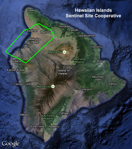
Title: Hawaiian Islands Sentinel Site Cooperative: West Hawaii Focus Area
Originator: NOAA Sentinel Site Program
Publication Date: January 25, 2016
Description:
Abstract:
The Hawaiian Islands Sentinel Site Cooperative (SSC) is one of five areas across the country that make up NOAA's Sentinel Site Program. This program brings together a network of people from across different levels of government, community involvement, NGOs and other stakeholders, expertise, and existing NOAA tools and services within specific geographic regions to tackle problems faced by coastal communities. The initial focus areas for the Hawaiian Islands SSC are to restore damaged wetlands by monitoring rainfall, stream flow, and salt water intrusion; balance human needs with ecosystem health; and to find solutions to local problems related to coastal inundation and sea level change.
This layer outlines the SSC project boundary for a portion of the west coast of Hawaii Island (Big Island).
For further information, please see:
http://oceanservice.noaa.gov/sentinelsites/hawaii.html
Purpose: PacIOOS provides timely, reliable, and accurate ocean information to support a safe, clean, productive ocean and resilient coastal zone in the U.S. Pacific Islands region.
Spatial Domain:
Bounding Coordinates:
West Bounding Coordinate: -156.10173°
East Bounding Coordinate: -155.57940°
North Bounding Coordinate: 20.10632°
South Bounding Coordinate: 19.71124°
Keywords:
Theme:
Theme Keyword Thesaurus: GCMD Science Keywords
Keyword: Earth Science Human Dimensions Boundaries Administrative Divisions
Keyword: Earth Science Human Dimensions Environmental Governance/Management
Keyword: Earth Science Human Dimensions Environmental Impacts Conservation
Place:
Place Keyword Thesaurus: GCMD Location Keywords
Place Keyword: Continent North America United States Of America Hawaii
Place Keyword: Ocean Pacific Ocean Central Pacific Ocean Hawaiian Islands Big Island
Place Keyword: Ocean Pacific Ocean Central Pacific Ocean Hawaiian Islands Hawaii Island North Kona
Place Keyword: Ocean Pacific Ocean Central Pacific Ocean Hawaiian Islands Hawaii Island South Kohala
Access Constraints:
None
Use Constraints:
Use Limitation: The data may be used and redistributed for free but is not intended for legal use, since it may contain inaccuracies. Neither the data Contributor, University of Hawaii, PacIOOS, NOAA, State of Hawaii nor the United States Government, nor any of their employees or contractors, makes any warranty, express or implied, including warranties of merchantability and fitness for a particular purpose, or assumes any legal liability for the accuracy, completeness, or usefulness, of this information.
Point of Contact:
Contact Information:
Contact Organization Primary:
Contact Organization: NOAA Sentinel Site Program
Contact Electronic Mail Address: nos.info@noaa.gov
Data Set Credit:
The Pacific Islands Ocean Observing System (PacIOOS) is funded through the National Oceanic and Atmospheric Administration (NOAA) as a Regional Association within the U.S. Integrated Ocean Observing System (IOOS). PacIOOS is coordinated by the University of Hawaii School of Ocean and Earth Science and Technology (SOEST).
Browse Graphic:
View full image
Browse Graphic File Name: http://www.pacioos.hawaii.edu/metadata/browse/hi_noaa_bigi_sentinel.png
Browse Graphic File Description:
Sample image.
Browse Graphic File Type: PNG
Back to Top
