Dataset Identifier:
hi_noaa_maui_benthic_habitats
Citation:
Citation Information:
Title: NOAA Shallow-Water Benthic Habitats: Hawaii: Maui
Originator: NOAA National Centers for Coastal Ocean Science (NCCOS)
Publication Date: November 22, 2017
Description:
Abstract:
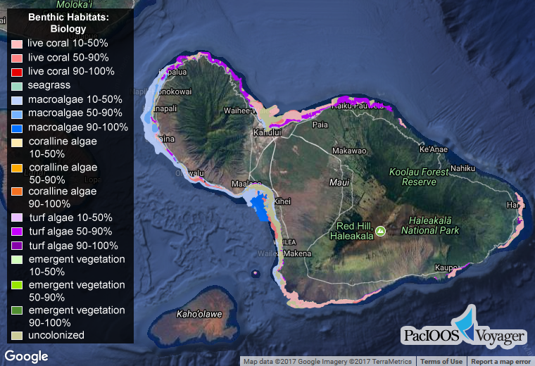
Benthic habitat maps for the nearshore, shallow (< 30 m) coastal waters of the island of Maui in the State of Hawaii. NOAA's National Centers for Coastal Ocean Science (NCCOS) produced these data to support coral reef research and management. Habitat regions were digitally identified using visual interpretation of orthorectified satellite imagery with a minimum mapping unit (MMU) of approximately 1 acre. Includes biological cover types, geomorphological structure types, and geographic zones.
Eighteen distinct and non-overlapping biological cover types were identified. Habitats or features that cover areas smaller than the minimal mapping unit of 1 acre were not considered. For example, uncolonized sand halos surrounding coral patch reefs are too small to be mapped independently. Cover type refers only to the predominant biological component colonizing the surface of the feature and does not address location (e.g., on the shelf or in the lagoon). The cover types are defined in a collapsible hierarchy ranging from eight major classes (live coral, seagrass, macroalgae, encrusting/coralline algae, turf algae, emergent vegetation, uncolonized, and unknown), combined with a density modifier representing the percentage of the predominant cover type (10%-<50% sparse, 50%-<90% patchy, 90%-100% continuous).
Similarly, 14 distinct and non-overlapping geomorphological structure types were identified. The structure types are defined in a collapsible hierarchy ranging from four major classes (coral reef and hardbottom, unconsolidated sediment, other delineations, and unknown), to thirteen detailed classes: sand, mud, spur and groove, individual and aggregated patch reef, aggregate reef, scattered coral/rock in unconsolidated sediment, pavement, rock/boulder (volcanic and carbonate), reef rubble, pavement with sand channels, artificial, and unknown.
Lastly, 13 mutually exclusive geographic zones were identified from land to open water corresponding to typical insular shelf and coral reef geomorphology. These zones include: shoreline intertidal, vertical wall (none identified), lagoon, back reef, reef flat, reef crest, fore reef, bank/shelf, bank/shelf escarpment, channel, dredged (since this condition eliminates natural geomorphology), unknown, and land. Zone refers only to each benthic community's location and does not address substrate or cover types within. For example, the lagoon zone may include patch reefs, sand, and seagrass beds; however, these are considered structural elements that may or may not occur within the lagoon zone and therefore, are not used to define it.
Purpose: PacIOOS provides timely, reliable, and accurate ocean information to support a safe, clean, productive ocean and resilient coastal zone in the U.S. Pacific Islands region.
Spatial Domain:
Bounding Coordinates:
West Bounding Coordinate: -156.72291°
East Bounding Coordinate: -155.95997°
North Bounding Coordinate: 21.04782°
South Bounding Coordinate: 20.56410°
Keywords:
Theme:
Theme Keyword Thesaurus: GCMD Science Keywords
Keyword: Earth Science Biological Classification Plants Angiosperms (Flowering Plants) Monocots Seagrass
Keyword: Earth Science Biosphere Aquatic Ecosystems Benthic Habitat
Keyword: Earth Science Biosphere Vegetation
Keyword: Earth Science Land Surface Geomorphology Coastal Landforms/Processes
Keyword: Earth Science Oceans Coastal Processes Coral Reefs
Keyword: Earth Science Solid Earth Geomorphic Landforms/Processes Coastal Landforms Coral Reefs
Keyword: Earth Science Solid Earth Geomorphic Landforms/Processes Coastal Landforms Coral Reefs Patch Reef
Place:
Place Keyword Thesaurus: GCMD Location Keywords
Place Keyword: Continent North America United States Of America Hawaii
Place Keyword: Ocean Pacific Ocean Central Pacific Ocean Hawaiian Islands Maui
Access Constraints:
None
Use Constraints:
Use Limitation: The data may be used and redistributed for free but is not intended for legal use, since it may contain inaccuracies. Neither the data Contributor, University of Hawaii, PacIOOS, NOAA, State of Hawaii nor the United States Government, nor any of their employees or contractors, makes any warranty, express or implied, including warranties of merchantability and fitness for a particular purpose, or assumes any legal liability for the accuracy, completeness, or usefulness, of this information.
Point of Contact:
Contact Information:
Contact Organization Primary:
Contact Organization: NOAA National Centers for Coastal Ocean Science (NCCOS)
Contact Electronic Mail Address: nccos.webcontent@noaa.gov
Data Set Credit:
The Pacific Islands Ocean Observing System (PacIOOS) is funded through the National Oceanic and Atmospheric Administration (NOAA) as a Regional Association within the U.S. Integrated Ocean Observing System (IOOS). PacIOOS is coordinated by the University of Hawaii School of Ocean and Earth Science and Technology (SOEST).
Browse Graphic:
View full image
Browse Graphic File Name: http://www.pacioos.hawaii.edu/metadata/browse/hi_noaa_maui_benthic_habitats.png
Browse Graphic File Description:
Sample image.
Browse Graphic File Type: PNG
Back to Top
