Citation:
Citation Information:
Title:
Papahanaumokuakea Marine National Monument (PMNM) - Northwestern Hawaiian Islands (NWHI)
Date:
Date: January 25, 2016
Date Type:
creation
(CI_DateTypeCode)
Identifier:
Code:
hi_noaa_nwhi_papahanaumokuakea
Authority:
org.pacioos
Responsible Party:
Organization Name:
Papahanaumokuakea Marine National Monument (PMNM)
Contact:
Contact Address:
Email:
hawaiireef@noaa.gov
Online Resource:
Linkage: http://papahanaumokuakea.gov
Protocol:
http
Function:
information
(CI_OnLineFunctionCode)
Contact Role:
originator
(CI_RoleCode)
Responsible Party:
Organization Name:
Pacific Islands Ocean Observing System (PacIOOS)
Contact:
Contact Address:
Email:
info@pacioos.org
Online Resource:
Linkage: http://pacioos.org
Protocol:
http
Function:
information
(CI_OnLineFunctionCode)
Contact Role:
publisher
(CI_RoleCode)
Suggested data citation: Papahanaumokuakea Marine National Monument (PMNM). 2016. Papahanaumokuakea Marine National Monument (PMNM) - Northwestern Hawaiian Islands (NWHI). Distributed by the Pacific Islands Ocean Observing System (PacIOOS). http://pacioos.org/metadata/hi_noaa_nwhi_papahanaumokuakea.html. Accessed [date].
Abstract:
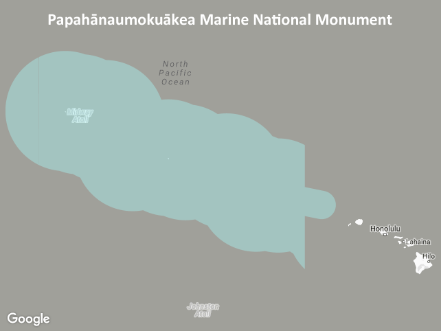
Boundary of the Papahanaumokuakea Marine National Monument (PMNM), located in the Northwestern Hawaiian Islands (NWHI). Created in 2006, Papahanaumokuakea is the largest conservation area in the U.S. and one of the largest marine conservation areas in the world. It is home to extensive coral reefs harboring over 7,000 marine species, one quarter of which are found only in Hawaii. Many of the islands and shallow water environments are important habitats for rare species such as the threatened green sea turtle and the endangered Hawaiian monk seal. Significant cultural Native Hawaiian sites can also be found on the islands of Nihoa and Mokumanamana (Necker Island). Co-managed with the State of Hawaii and the U.S. Department of the Interior, the monument preserves one of the most untouched areas of coral reef in the world.
This layer shows the PMNM boundary after its expansion in 2016. On August 26, 2016, President Obama signed a proclamation expanding the monument from 139,797 square miles (362,073 square kilometers) to 582,578 square miles (1,508,870 square kilometers). This extended the monument boundary westward of -163 degrees longitude out to Hawaii's Exclusive Economic Zone (EEZ) at 200 nautical miles offshore. The present layer shows the monument boundary as it existed *after* this expansion. To view the previous, smaller boundary, access the data layer for "hi_noaa_nwhi_papahanaumokuakea_2006" instead.
NOTE: This layer is provided as polygon features. For polyline features, please see the layer named "hi_noaa_nwhi_papahanaumokuakea_line" instead. Both polygon and polyline formats are provided for this dataset because the monument boundary spans the antimeridian (+/-180 degrees longitude) making it difficult to display in many GIS software applications without showing a division at the antimeridian.
Purpose:
PacIOOS provides timely, reliable, and accurate ocean information to support a safe, clean, productive ocean and resilient coastal zone in the U.S. Pacific Islands region.
Credit:
The Pacific Islands Ocean Observing System (PacIOOS) is funded through the National Oceanic and Atmospheric Administration (NOAA) as a Regional Association within the U.S. Integrated Ocean Observing System (IOOS). PacIOOS is coordinated by the University of Hawaii School of Ocean and Earth Science and Technology (SOEST).
Point of Contact:
Responsible Party:
Organization Name:
Papahanaumokuakea Marine National Monument (PMNM)
Contact:
Contact Address:
Email:
hawaiireef@noaa.gov
Online Resource:
Linkage: http://papahanaumokuakea.gov
Protocol:
http
Function:
information
(CI_OnLineFunctionCode)
Contact Role:
pointOfContact
(CI_RoleCode)
Browse Graphic:
View full image
Image File: http://www.pacioos.hawaii.edu/metadata/browse/hi_noaa_nwhi_papahanaumokuakea.png
File Description:
Sample image.
Descriptive Keywords:
Keywords:
Keyword Type:
theme
(MD_KeywordTypeCode)
Keyword: Earth Science Human Dimensions Boundaries Administrative Divisions
Keyword: Earth Science Human Dimensions Environmental Governance/Management
Keyword: Earth Science Human Dimensions Environmental Impacts Conservation
Keyword Thesaurus:
Citation Information:
Title:
GCMD Science Keywords
Keywords:
Keyword Type:
place
(MD_KeywordTypeCode)
Keyword: Continent North America United States Of America Hawaii
Keyword: Ocean Pacific Ocean Central Pacific Ocean Hawaiian Islands Northwestern Hawaiian Islands
Keyword Thesaurus:
Citation Information:
Title:
GCMD Location Keywords
Keywords:
Keyword Type:
project
(MD_KeywordTypeCode)
Keyword: PacIOOS Pacific Islands Ocean Observing System
Keyword Thesaurus:
Citation Information:
Title:
GCMD Project Keywords
Keywords:
Keyword Type:
dataCenter
(MD_KeywordTypeCode)
Keyword: PacIOOS Pacific Islands Ocean Observing System
Keyword Thesaurus:
Citation Information:
Title:
GCMD Data Center Keywords
Aggregation Information:
Aggregate Dataset Name:
Citation Information:
Title:
Pacific Islands Ocean Observing System (PacIOOS)
Association Type: largerWorkCitation (DS_AssociationTypeCode)
Initiative Type: project (DS_InitiativeTypeCode)
Resource Constraints:
Legal Constraints:
Use Limitation:
The data may be used and redistributed for free but is not intended for legal use, since it may contain inaccuracies. Neither the data Contributor, University of Hawaii, PacIOOS, NOAA, State of Hawaii nor the United States Government, nor any of their employees or contractors, makes any warranty, express or implied, including warranties of merchantability and fitness for a particular purpose, or assumes any legal liability for the accuracy, completeness, or usefulness, of this information.
Language:
eng
Topic Category:
boundaries
Topic Category:
environment
Extent Information:
Spatial Temporal Extent:
Geographic Element:
Bounding Coordinates:
Westbound Longitude: -179.99999°
Eastbound Longitude: 179.99983°
Southbound Latitude: 19.23457°
Northbound Latitude: 31.79786°
Services:
Service Identification:
Identifier: OGC-WFS
Service Type:
Open Geospatial Consortium Web Feature Service (WFS)
Contains Operation:
Operation Name:
GetCapabilities
Online Resource:
Linkage: https://geo.pacioos.hawaii.edu/geoserver/PACIOOS/hi_noaa_nwhi_papahanaumokuakea/ows?service=WFS&version=1.0.0&request=GetCapabilities
Name:
OGC-WFS
Protocol:
OGC:WFS
Description:
Open Geospatial Consortium Web Feature Service (WFS). Supported WFS versions include 1.0.0, 1.1.0, and 2.0.0. Supported output formats include CSV, GeoJSON, GeoJSON-P, GML, KML, and Shapefile (Zipped).
Function:
download
(CI_OnLineFunctionCode)
Services:
Service Identification:
Identifier: OGC-WMS
Service Type:
Open Geospatial Consortium Web Map Service (WMS)
Contains Operation:
Operation Name:
GetCapabilities
Online Resource:
Linkage: https://geo.pacioos.hawaii.edu/geoserver/PACIOOS/hi_noaa_nwhi_papahanaumokuakea/ows?service=WMS&version=1.3.0&request=GetCapabilities
Name:
OGC-WMS
Protocol:
OGC:WMS
Description:
Open Geospatial Consortium Web Map Service (WMS). Supported WMS versions include 1.1.1 and 1.3.0. Supported map formats include AtomPub, GeoRSS, GeoTIFF, GIF, JPEG, KML/KMZ, PDF, PNG, SVG, and TIFF. Supported info formats include GeoJSON, GeoJSON-P, GML, HTML, and plain text.
Function:
download
(CI_OnLineFunctionCode)
Back to Top
