Non-commercial Boat-based Net Fishing Estimated Average Annual Catch of Reef Fish, 2004-2013 - Hawaii
Identification Information
Citation:
Citation Information:
Title:
Non-commercial Boat-based Net Fishing Estimated Average Annual Catch of Reef Fish, 2004-2013 - Hawaii
Date:
Date: April 18, 2017
Date Type:
creation
(CI_DateTypeCode)
Identifier:
Code:
hi_otp_all_fishing_rec_boat_net
Authority:
org.pacioos
Responsible Party:
Individual Name:
Carrie V. Kappel
Organization Name:
National Center for Ecological Analysis and Synthesis (NCEAS)
Contact:
Contact Address:
Email:
kappel@nceas.ucsb.edu
Online Resource:
Linkage: http://oceantippingpoints.org/about-us/people#Carrie
Protocol:
http
Function:
information
(CI_OnLineFunctionCode)
Contact Role:
principalInvestigator
(CI_RoleCode)
Responsible Party:
Individual Name:
Kimberly A. Selkoe
Organization Name:
National Center for Ecological Analysis and Synthesis (NCEAS)
Contact:
Contact Address:
Email:
selkoe@nceas.ucsb.edu
Online Resource:
Linkage: http://oceantippingpoints.org/about-us/people#Kim
Protocol:
http
Function:
information
(CI_OnLineFunctionCode)
Contact Role:
originator
(CI_RoleCode)
Responsible Party:
Organization Name:
Ocean Tipping Points (OTP)
Contact:
Contact Address:
Email:
info@oceantippingpoints.org
Online Resource:
Linkage: http://oceantippingpoints.org
Protocol:
http
Function:
information
(CI_OnLineFunctionCode)
Contact Role:
resourceProvider
(CI_RoleCode)
Responsible Party:
Organization Name:
Pacific Islands Ocean Observing System (PacIOOS)
Contact:
Contact Address:
Email:
info@pacioos.org
Online Resource:
Linkage: http://pacioos.org
Protocol:
http
Function:
information
(CI_OnLineFunctionCode)
Contact Role:
publisher
(CI_RoleCode)
Other Citation Details:
Related publications: Wedding LM, Lecky J, Gove JM, Walecka HR, Donovan MK, et al. (2018) Advancing the integration of spatial data to map human and natural drivers on coral reefs. PLOS ONE 13(3): e0189792. https://doi.org/10.1371/journal.pone.0189792; McCoy KS, Williams ID, Friedlander AM, Ma H, Teneva L, Kittinger JN (2018) Estimating nearshore coral reef-associated fisheries production from the main Hawaiian Islands. PLoS ONE 13(4): e0195840. https://doi.org/10.1371/journal.pone.0195840.
Suggested data citation: Kappel, C.V., K.A. Selkoe, and Ocean Tipping Points (OTP). 2017. Non-commercial Boat-based Net Fishing Estimated Average Annual Catch of Reef Fish, 2004-2013 - Hawaii. Distributed by the Pacific Islands Ocean Observing System (PacIOOS). http://pacioos.org/metadata/hi_otp_all_fishing_rec_boat_net.html. Accessed [date].
Abstract:
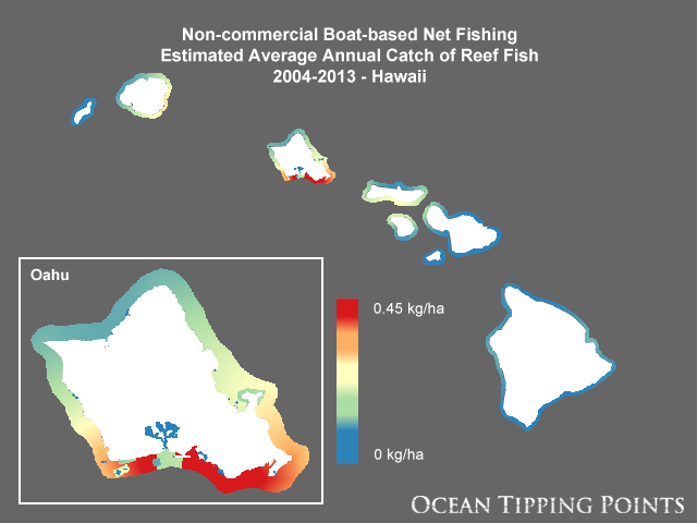
Nearshore fisheries in the Main Hawaiian Islands encompass a diverse group of fishers using a wide array of gears and targeting many different species. Communities in Hawaii often rely on these fisheries for economic, social, and cultural services. However, the stress from overfishing can cause ecosystem degradation and long-term economic loss. This layer represents the average annual catch of reef fish by non-commercial boat-based line fishing methods. Average annual catch at the island scale from 2004-2013 was estimated from Marine Recreational Information Program (MRIP) combined fisher intercept and phone survey data (McCoy et al., 2018). These island-scale estimates were spatially distributed offshore using distance to boat harbors and launch ramps while accounting for marine protected areas (MPAs) and de facto MPAs (e.g., military danger zones) where access is restricted. A Gaussian decay function assumed the majority of the catch occurs within 10-20 km of each harbor. Additionally, the Ocean Tipping Points (OTP) project weighted boat harbors by the human population present within 30 km. This layer's spatial footprint aligns with the inshore commercial reporting blocks for commercial fish catch reporting to the State of Hawaii Department of Aquatic Resources (DAR).
Point data for boat harbors and launch ramps were combined from two datasets available from the Hawaii Statewide GIS Program website (Harbors.shp and BoatingFacilities.shp) (http://planning.hawaii.gov/gis/download-gis-data/). Data were checked for quality to ensure only operational boat harbors and launch ramps were included and geographic positions were accurate. Anchorages, fishing piers, historic, and disused ramps/harbors were removed prior to analysis. Boat facility weighting factors were calculated based on total human population within 30 km of each boat harbor or ramp. Human population was mapped based on 2010 census data and LANDFIRE land use/land cover data using the USGS Dasymetric Mapping Tool to gain a more accurate representation of population distribution. A 30-km buffer was then created around each boating facility and a Zonal Statistics tool was used to sum the human population within each buffer. These population values were then used to assign weights to each boating facility in order to allocate a proportion of total island catch estimates to each boat harbor or ramp. These weights sum to 1 for each island.
In order to allocate catch proportionally to each boat harbor/ramp, estimated annual catch at the island scale and the human population-based weighting factor were joined to the attribute table of each boating facility's cost allocation footprint and used in a Gaussian decay function with each distance surface. This decay function assumes the majority of catch occurs within 10-20 km of a harbor or ramp and declines more rapidly with increasing distance. Catch in full no-take MPAs were set to zero and other areas with restricted access were reduced according to expert input and local knowledge. Pixel values within each boating facility's footprint were then rescaled such that the sum in each footprint was equal to the respective boat facility's weighting factor times the MRIP catch estimate for that island in units of kg per pixel. Finally, all raster layers for each boat harbor/ramp were summed together.
Final pixels values are in units of kg/ha such that the sum of all pixels for each island is equal to the estimates of average annual catch from McCoy et al. (2018). Units, pixel size, and grid alignment are consistent with all other OTP fishing layers so that they can be compared directly or added together for various uses.
Purpose:
This layer was developed as part of a geospatial database of key anthropogenic pressures to coastal waters of the Main Hawaiian Islands for the Ocean Tipping Points (OTP) project (http://oceantippingpoints.org). Ocean tipping points occur when shifts in human use or environmental conditions result in large, and sometimes abrupt, impacts to marine ecosystems. The ability to predict and understand ocean tipping points can enhance ecosystem management, including critical coral reef management and policies to protect ecosystem services produced by coral reefs. The goal of the Ocean Tipping Points Hawaii case study was to gather, process, and map spatial information on environmental and human-based drivers of coral reef ecosystem conditions.
Credit:
The Ocean Tipping Points project, 2016. Please acknowledge the Ocean Tipping Points project as a source when these data are used in the preparation of reports, papers, publications, maps, and other products. When applying these data for publication, please reference and cite the following journal article: Wedding LM, Lecky J, Gove JM, Walecka HR, Donovan MK, et al. (2018) Advancing the integration of spatial data to map human and natural drivers on coral reefs. PLOS ONE 13(3): e0189792. https://doi.org/10.1371/journal.pone.0189792.
Point of Contact:
Responsible Party:
Individual Name:
Carrie V. Kappel
Organization Name:
National Center for Ecological Analysis and Synthesis (NCEAS)
Contact:
Contact Address:
Email:
kappel@nceas.ucsb.edu
Online Resource:
Linkage: http://oceantippingpoints.org/about-us/people#Carrie
Protocol:
http
Function:
information
(CI_OnLineFunctionCode)
Contact Role:
pointOfContact
(CI_RoleCode)
Browse Graphic:
View full image
Image File: http://www.pacioos.hawaii.edu/metadata/browse/hi_otp_all_fishing_rec_boat_net.png
File Description:
Sample image.
Descriptive Keywords:
Keywords:
Keyword Type:
theme
(MD_KeywordTypeCode)
Keyword: Earth Science Agriculture Agricultural Aquatic Sciences Fisheries
Keyword: Earth Science Biosphere Aquatic Ecosystems Reef Habitat
Keyword: Earth Science Biosphere Ecosystems Marine Ecosystems Reef Coral Reef
Keyword: Earth Science Human Dimensions Environmental Impacts
Keyword: Earth Science Human Dimensions Human Settlements Coastal Areas
Keyword: Earth Science Human Dimensions Social Behavior Recreational Activities/Areas Fishing
Keyword: Earth Science Human Dimensions Sustainability Environmental Sustainability
Keyword: Earth Science Oceans Aquatic Sciences Fisheries
Keyword: Earth Science Oceans Coastal Processes Coral Reefs
Keyword Thesaurus:
Citation Information:
Title:
GCMD Science Keywords
Keywords:
Keyword Type:
place
(MD_KeywordTypeCode)
Keyword: Continent North America United States Of America Hawaii
Keyword: Ocean Pacific Ocean Central Pacific Ocean Hawaiian Islands
Keyword Thesaurus:
Citation Information:
Title:
GCMD Location Keywords
Keywords:
Keyword Type:
project
(MD_KeywordTypeCode)
Keyword: PacIOOS Pacific Islands Ocean Observing System
Keyword Thesaurus:
Citation Information:
Title:
GCMD Project Keywords
Keywords:
Keyword Type:
dataCenter
(MD_KeywordTypeCode)
Keyword: PacIOOS Pacific Islands Ocean Observing System
Keyword Thesaurus:
Citation Information:
Title:
GCMD Data Center Keywords
Aggregation Information:
Aggregate Dataset Name:
Citation Information:
Title:
Pacific Islands Ocean Observing System (PacIOOS)
Association Type: largerWorkCitation (DS_AssociationTypeCode)
Initiative Type: project (DS_InitiativeTypeCode)
Resource Constraints:
Legal Constraints:
Use Limitation:
Please contact the Ocean Tipping Points (OTP) project in advance of applying these data to project work so that the principal investigator, Carrie Kappel (kappel@nceas.ucsb.edu), can track and communicate data uses and ensure no duplicate efforts are underway. The data may be used and redistributed for free but is not intended for legal use, since it may contain inaccuracies. Neither the data Contributor, University of Hawaii, PacIOOS, NOAA, State of Hawaii nor the United States Government, nor any of their employees or contractors, makes any warranty, express or implied, including warranties of merchantability and fitness for a particular purpose, or assumes any legal liability for the accuracy, completeness, or usefulness, of this information.
Language:
eng
Topic Category:
biota
Topic Category:
environment
Topic Category:
farming
Topic Category:
oceans
Topic Category:
society
Extent Information:
Spatial Temporal Extent:
Geographic Element:
Bounding Coordinates:
Westbound Longitude: -160.82743°
Eastbound Longitude: -154.24231°
Southbound Latitude: 18.50382°
Northbound Latitude: 22.58996°
Services:
Service Identification:
Identifier: OGC-WCS
Service Type:
Open Geospatial Consortium Web Coverage Service (WCS)
Contains Operation:
Operation Name:
GetCapabilities
Online Resource:
Linkage: https://geo.pacioos.hawaii.edu/geoserver/PACIOOS/hi_otp_all_fishing_rec_boat_net/ows?service=WCS&version=1.0.0&request=GetCapabilities
Name:
OGC-WCS
Protocol:
OGC:WCS
Description:
Open Geospatial Consortium Web Coverage Service (WCS). Supported WCS versions include 1.0.0, 1.1.0, and 1.1.1. Supported output formats include GeoTIFF, GIF, JPEG, PNG, or TIFF.
Function:
download
(CI_OnLineFunctionCode)
Services:
Service Identification:
Identifier: OGC-WMS
Service Type:
Open Geospatial Consortium Web Map Service (WMS)
Contains Operation:
Operation Name:
GetCapabilities
Online Resource:
Linkage: https://geo.pacioos.hawaii.edu/geoserver/PACIOOS/hi_otp_all_fishing_rec_boat_net/ows?service=WMS&version=1.3.0&request=GetCapabilities
Name:
OGC-WMS
Protocol:
OGC:WMS
Description:
Open Geospatial Consortium Web Map Service (WMS). Supported WMS versions include 1.1.1 and 1.3.0. Supported map formats include AtomPub, GeoRSS, GeoTIFF, GIF, JPEG, KML/KMZ, PDF, PNG, SVG, and TIFF. Supported info formats include GeoJSON, GeoJSON-P, GML, HTML, and plain text.
Function:
download
(CI_OnLineFunctionCode)
Back to Top
Data Quality Information
Scope:
dataset
Lineage:
Statement:
2017-04-18T00:00:00Z OGC web services (WMS and WFS) enabled by PacIOOS via GeoServer. Original data from source provider may have been reformatted, reprojected, or adjusted in other ways to optimize these capabilities.
Back to Top
Spatial Representation Information
Metadata Reference Information
|
|
