Dataset Identifier:
hi_pacioos_all_seal_monk_hawaiian
Citation:
Citation Information:
Title: Species Distribution: Hawaiian Monk Seal - Hawaii
Originator: Pacific Islands Ocean Observing System (PacIOOS)
Originator: Charles Littnan
Publication Date: January 31, 2018
Description:
Abstract:
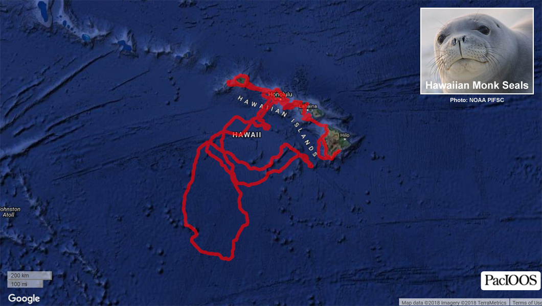
This dataset contains a collection of known point locations of Hawaiian monk seals identified via automated satellite tracking of tagged organisms. This can be useful for assessing species abundance, population structure, habitat use, and behavior. This collection is aggregated from multiple tagged organisms and survey periods. Each data point contains attributes for further information about the time and source of the observation. This dataset was compiled by the Pacific Islands Ocean Observing System (PacIOOS) and may be updated in the future if additional data sources are acquired.
NOAA's Pacific Islands Fisheries Science Center (PIFSC) deploys satellite tags on Hawaiian monk seals to track their movements around the main Hawaiian Islands with the intent of improving our understanding and assisting in the recovery of this critically endangered species.
For further information, please see:
http://www.pifsc.noaa.gov/hawaiian_monk_seal/
Purpose: PacIOOS provides timely, reliable, and accurate ocean information to support a safe, clean, productive ocean and resilient coastal zone in the U.S. Pacific Islands region.
Spatial Domain:
Bounding Coordinates:
West Bounding Coordinate: -162.01738°
East Bounding Coordinate: -155.32842°
North Bounding Coordinate: 22.27691°
South Bounding Coordinate: 14.75460°
Keywords:
Theme:
Theme Keyword Thesaurus: GCMD Science Keywords
Keyword: Earth Science Biological Classification Animals/Vertebrates Mammals Carnivores Seals/Sea Lions/Walruses Hawaiian Monk Seal
Keyword: Earth Science Biosphere Aquatic Ecosystems Marine Habitat
Place:
Place Keyword Thesaurus: GCMD Location Keywords
Place Keyword: Continent North America United States Of America Hawaii
Place Keyword: Ocean Pacific Ocean Central Pacific Ocean Hawaiian Islands
Access Constraints:
None
Use Constraints:
Use Limitation: The data may be used and redistributed for free but is not intended for legal use, since it may contain inaccuracies. Neither the data Contributor, University of Hawaii, PacIOOS, NOAA, State of Hawaii nor the United States Government, nor any of their employees or contractors, makes any warranty, express or implied, including warranties of merchantability and fitness for a particular purpose, or assumes any legal liability for the accuracy, completeness, or usefulness, of this information.
Point of Contact:
Contact Information:
Contact Organization Primary:
Contact Organization: Pacific Islands Ocean Observing System (PacIOOS)
Contact Electronic Mail Address: info@pacioos.org
Data Set Credit:
The Pacific Islands Ocean Observing System (PacIOOS) is funded through the National Oceanic and Atmospheric Administration (NOAA) as a Regional Association within the U.S. Integrated Ocean Observing System (IOOS). PacIOOS is coordinated by the University of Hawaii School of Ocean and Earth Science and Technology (SOEST).
Browse Graphic:
View full image
Browse Graphic File Name: http://www.pacioos.hawaii.edu/metadata/browse/hi_pacioos_all_seal_monk_hawaiian.png
Browse Graphic File Description:
Sample image.
Browse Graphic File Type: PNG
Back to Top
