Citation:
Citation Information:
Title:
Species Distribution: Longman's Beaked Whale - Hawaii
Date:
Date: January 31, 2018
Date Type:
creation
(CI_DateTypeCode)
Identifier:
Code:
hi_pacioos_all_whale_beaked_longmans
Authority:
org.pacioos
Responsible Party:
Organization Name:
Pacific Islands Ocean Observing System (PacIOOS)
Contact:
Contact Address:
Email:
info@pacioos.org
Online Resource:
Linkage: http://pacioos.org
Protocol:
http
Function:
information
(CI_OnLineFunctionCode)
Contact Role:
originator
(CI_RoleCode)
Responsible Party:
Individual Name:
Robin W. Baird
Organization Name:
Cascadia Research Collective (CRC)
Contact:
Contact Address:
Email:
rwbaird@cascadiaresearch.org
Online Resource:
Linkage: http://www.cascadiaresearch.org
Protocol:
http
Function:
information
(CI_OnLineFunctionCode)
Contact Role:
originator
(CI_RoleCode)
Responsible Party:
Organization Name:
Pacific Islands Ocean Observing System (PacIOOS)
Contact:
Contact Address:
Email:
info@pacioos.org
Online Resource:
Linkage: http://pacioos.org
Protocol:
http
Function:
information
(CI_OnLineFunctionCode)
Contact Role:
publisher
(CI_RoleCode)
Suggested data citation: Pacific Islands Ocean Observing System (PacIOOS) and R.W. Baird. 2018, updated 2020. Species Distribution: Longman's Beaked Whale - Hawaii. Distributed by the Pacific Islands Ocean Observing System (PacIOOS). http://pacioos.org/metadata/hi_pacioos_all_whale_beaked_longmans.html. Accessed [date].
Abstract:
This dataset contains one known point location of the elusive Longman's beaked whale identified through direct human observation via shipborne survey in 2007. Cascadia Research Collective (CRC) has been undertaking surveys for odontocetes in Hawaiian waters since 2000.
For further information, please see:
http://www.cascadiaresearch.org/hawaiian-cetacean-studies/beaked-whales-hawaii
Purpose:
PacIOOS provides timely, reliable, and accurate ocean information to support a safe, clean, productive ocean and resilient coastal zone in the U.S. Pacific Islands region.
Credit:
The Pacific Islands Ocean Observing System (PacIOOS) is funded through the National Oceanic and Atmospheric Administration (NOAA) as a Regional Association within the U.S. Integrated Ocean Observing System (IOOS). PacIOOS is coordinated by the University of Hawaii School of Ocean and Earth Science and Technology (SOEST).
Point of Contact:
Responsible Party:
Organization Name:
Pacific Islands Ocean Observing System (PacIOOS)
Contact:
Contact Address:
Email:
info@pacioos.org
Online Resource:
Linkage: http://pacioos.org
Protocol:
http
Function:
information
(CI_OnLineFunctionCode)
Contact Role:
pointOfContact
(CI_RoleCode)
Browse Graphic:
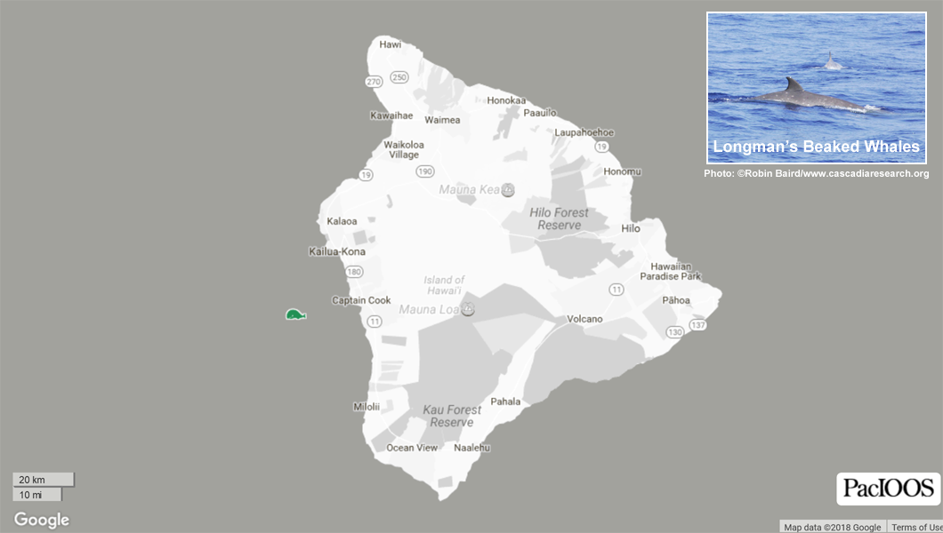
View full image
Image File: http://www.pacioos.hawaii.edu/metadata/browse/hi_pacioos_all_whale_beaked_longmans.png
File Description:
Sample image.
Descriptive Keywords:
Keywords:
Keyword Type:
theme
(MD_KeywordTypeCode)
Keyword: Earth Science Biological Classification Animals/Vertebrates Mammals Cetaceans Toothed Whales Longman's Beaked Whale
Keyword: Earth Science Biosphere Aquatic Ecosystems Marine Habitat
Keyword Thesaurus:
Citation Information:
Title:
GCMD Science Keywords
Keywords:
Keyword Type:
place
(MD_KeywordTypeCode)
Keyword: Continent North America United States Of America Hawaii
Keyword: Ocean Pacific Ocean Central Pacific Ocean Hawaiian Islands
Keyword Thesaurus:
Citation Information:
Title:
GCMD Location Keywords
Keywords:
Keyword Type:
project
(MD_KeywordTypeCode)
Keyword: PacIOOS Pacific Islands Ocean Observing System
Keyword Thesaurus:
Citation Information:
Title:
GCMD Project Keywords
Keywords:
Keyword Type:
dataCenter
(MD_KeywordTypeCode)
Keyword: PacIOOS Pacific Islands Ocean Observing System
Keyword Thesaurus:
Citation Information:
Title:
GCMD Data Center Keywords
Aggregation Information:
Aggregate Dataset Name:
Citation Information:
Title:
Pacific Islands Ocean Observing System (PacIOOS)
Association Type: largerWorkCitation (DS_AssociationTypeCode)
Initiative Type: project (DS_InitiativeTypeCode)
Resource Constraints:
Legal Constraints:
Use Limitation:
The data may be used and redistributed for free but is not intended for legal use, since it may contain inaccuracies. Neither the data Contributor, University of Hawaii, PacIOOS, NOAA, State of Hawaii nor the United States Government, nor any of their employees or contractors, makes any warranty, express or implied, including warranties of merchantability and fitness for a particular purpose, or assumes any legal liability for the accuracy, completeness, or usefulness, of this information.
Language:
eng
Topic Category:
biota
Topic Category:
oceans
Extent Information:
Spatial Temporal Extent:
Geographic Element:
Bounding Coordinates:
Westbound Longitude: -156.124°
Eastbound Longitude: -156.1238°
Southbound Latitude: 19.4573°
Northbound Latitude: 19.4575°
Services:
Service Identification:
Identifier: OGC-WFS
Service Type:
Open Geospatial Consortium Web Feature Service (WFS)
Contains Operation:
Operation Name:
GetCapabilities
Online Resource:
Linkage: https://geo.pacioos.hawaii.edu/geoserver/PACIOOS/hi_pacioos_all_whale_beaked_longmans/ows?service=WFS&version=1.0.0&request=GetCapabilities
Name:
OGC-WFS
Protocol:
OGC:WFS
Description:
Open Geospatial Consortium Web Feature Service (WFS). Supported WFS versions include 1.0.0, 1.1.0, and 2.0.0. Supported output formats include CSV, GeoJSON, GeoJSON-P, GML, KML, and Shapefile (Zipped).
Function:
download
(CI_OnLineFunctionCode)
Services:
Service Identification:
Identifier: OGC-WMS
Service Type:
Open Geospatial Consortium Web Map Service (WMS)
Contains Operation:
Operation Name:
GetCapabilities
Online Resource:
Linkage: https://geo.pacioos.hawaii.edu/geoserver/PACIOOS/hi_pacioos_all_whale_beaked_longmans/ows?service=WMS&version=1.3.0&request=GetCapabilities
Name:
OGC-WMS
Protocol:
OGC:WMS
Description:
Open Geospatial Consortium Web Map Service (WMS). Supported WMS versions include 1.1.1 and 1.3.0. Supported map formats include AtomPub, GeoRSS, GeoTIFF, GIF, JPEG, KML/KMZ, PDF, PNG, SVG, and TIFF. Supported info formats include GeoJSON, GeoJSON-P, GML, HTML, and plain text.
Function:
download
(CI_OnLineFunctionCode)
Back to Top
