Dataset Identifier:
hi_sohdop_oahu_piers
Citation:
Citation Information:
Title: Piers - Oahu, Hawaii
Originator: Hawaii Statewide GIS Program
Publication Date: January 25, 2016
Description:
Abstract:
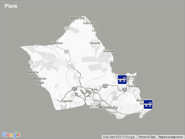
Displays the locations of two piers for the State of Hawaii. While harbors may also have piers, these sites solely provide a pier and no other facilities. A pier is a platform built out from the shore into the water and supported by piles to provide access to ships and boats. This overlay includes two such piers: Lilipuna Pier in Kaneohe Bay and Makai Pier in Waimanalo, both on Oahu.
Purpose: PacIOOS provides timely, reliable, and accurate ocean information to support a safe, clean, productive ocean and resilient coastal zone in the U.S. Pacific Islands region.
Spatial Domain:
Bounding Coordinates:
West Bounding Coordinate: -157.79189°
East Bounding Coordinate: -157.66854°
North Bounding Coordinate: 21.42971°
South Bounding Coordinate: 21.31975°
Keywords:
Theme:
Theme Keyword Thesaurus: GCMD Science Keywords
Keyword: Earth Science Human Dimensions Infrastructure Piers
Place:
Place Keyword Thesaurus: GCMD Location Keywords
Place Keyword: Continent North America United States Of America Hawaii
Place Keyword: Ocean Pacific Ocean Central Pacific Ocean Hawaiian Islands Oahu
Access Constraints:
None
Use Constraints:
Use Limitation: The data may be used and redistributed for free but is not intended for legal use, since it may contain inaccuracies. Neither the data Contributor, University of Hawaii, PacIOOS, NOAA, State of Hawaii nor the United States Government, nor any of their employees or contractors, makes any warranty, express or implied, including warranties of merchantability and fitness for a particular purpose, or assumes any legal liability for the accuracy, completeness, or usefulness, of this information.
Point of Contact:
Contact Information:
Contact Organization Primary:
Contact Organization: Hawaii Statewide GIS Program
Contact Electronic Mail Address: gis@hawaii.gov
Data Set Credit:
The Pacific Islands Ocean Observing System (PacIOOS) is funded through the National Oceanic and Atmospheric Administration (NOAA) as a Regional Association within the U.S. Integrated Ocean Observing System (IOOS). PacIOOS is coordinated by the University of Hawaii School of Ocean and Earth Science and Technology (SOEST).
Browse Graphic:
View full image
Browse Graphic File Name: http://www.pacioos.hawaii.edu/metadata/browse/hi_sohdop_oahu_piers.png
Browse Graphic File Description:
Sample image.
Browse Graphic File Type: PNG
Back to Top
