Citation:
Citation Information:
Title:
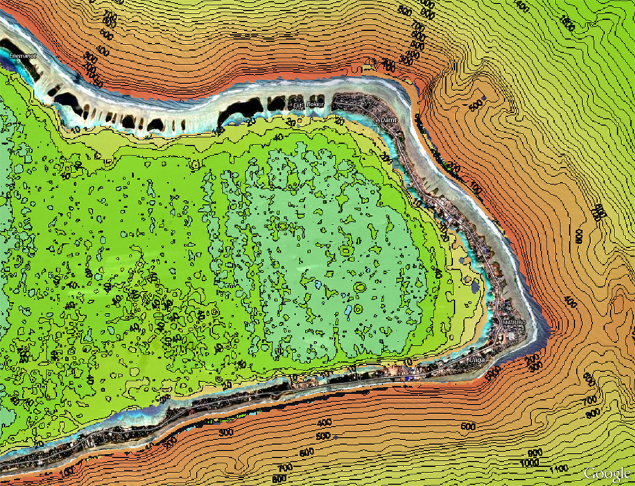
Bathymetry With Contours - Majuro, Marshall Islands
Date:
Date: January 25, 2016
Date Type:
creation
(CI_DateTypeCode)
Identifier:
Code:
mh_sopac_maj_bathy_color
Authority:
org.pacioos
Responsible Party:
Organization Name:
SPC Geoscience, Energy and Maritime (GEM) Division
Contact:
Contact Address:
Email:
spc@spc.int
Online Resource:
Linkage: https://gem.spc.int
Protocol:
http
Function:
information
(CI_OnLineFunctionCode)
Contact Role:
originator
(CI_RoleCode)
Responsible Party:
Organization Name:
Pacific Islands Ocean Observing System (PacIOOS)
Contact:
Contact Address:
Email:
info@pacioos.org
Online Resource:
Linkage: http://pacioos.org
Protocol:
http
Function:
information
(CI_OnLineFunctionCode)
Contact Role:
publisher
(CI_RoleCode)
Suggested data citation: SPC Geoscience, Energy and Maritime (GEM) Division. 2016. Bathymetry With Contours - Majuro, Marshall Islands. Distributed by the Pacific Islands Ocean Observing System (PacIOOS). http://pacioos.org/metadata/mh_sopac_maj_bathy_color.html. Accessed [date].
Abstract:
From multibeam bathymetry surveys carried out by the Pacific Community (SPC) Geoscience, Energy and Maritime (GEM) Division, formerly the South Pacific Applied Geoscience Commission (SOPAC), from 2003-2006. This work was implemented through the project "Reducing Vulnerability of Pacific States", funded by the European Development Fund. Ocean depth measured in meters.
Purpose:
PacIOOS provides timely, reliable, and accurate ocean information to support a safe, clean, productive ocean and resilient coastal zone in the U.S. Pacific Islands region.
Credit:
The Pacific Islands Ocean Observing System (PacIOOS) is funded through the National Oceanic and Atmospheric Administration (NOAA) as a Regional Association within the U.S. Integrated Ocean Observing System (IOOS). PacIOOS is coordinated by the University of Hawaii School of Ocean and Earth Science and Technology (SOEST).
Point of Contact:
Responsible Party:
Organization Name:
SPC Geoscience, Energy and Maritime (GEM) Division
Contact:
Contact Address:
Email:
spc@spc.int
Online Resource:
Linkage: https://gem.spc.int
Protocol:
http
Function:
information
(CI_OnLineFunctionCode)
Contact Role:
pointOfContact
(CI_RoleCode)
Browse Graphic:
View full image
Image File: http://www.pacioos.hawaii.edu/metadata/browse/mh_sopac_maj_bathy_color.png
File Description:
Sample image.
Descriptive Keywords:
Keywords:
Keyword Type:
theme
(MD_KeywordTypeCode)
Keyword: Earth Science Oceans Bathymetry/Seafloor Topography Bathymetry
Keyword: Earth Science Oceans Bathymetry/Seafloor Topography Bathymetry Contour Maps
Keyword Thesaurus:
Citation Information:
Title:
GCMD Science Keywords
Keywords:
Keyword Type:
place
(MD_KeywordTypeCode)
Keyword: Ocean Pacific Ocean Western Pacific Ocean Micronesia Marshall Islands Majuro
Keyword: Ocean Pacific Ocean Western Pacific Ocean Micronesia Marshall Islands Republic of the Marshall Islands (RMI)
Keyword Thesaurus:
Citation Information:
Title:
GCMD Location Keywords
Keywords:
Keyword Type:
project
(MD_KeywordTypeCode)
Keyword: PacIOOS Pacific Islands Ocean Observing System
Keyword Thesaurus:
Citation Information:
Title:
GCMD Project Keywords
Keywords:
Keyword Type:
dataCenter
(MD_KeywordTypeCode)
Keyword: PacIOOS Pacific Islands Ocean Observing System
Keyword Thesaurus:
Citation Information:
Title:
GCMD Data Center Keywords
Aggregation Information:
Aggregate Dataset Name:
Citation Information:
Title:
Pacific Islands Ocean Observing System (PacIOOS)
Association Type: largerWorkCitation (DS_AssociationTypeCode)
Initiative Type: project (DS_InitiativeTypeCode)
Resource Constraints:
Legal Constraints:
Use Limitation:
The data may be used and redistributed for free but is not intended for legal use, since it may contain inaccuracies. Neither the data Contributor, University of Hawaii, PacIOOS, NOAA, State of Hawaii nor the United States Government, nor any of their employees or contractors, makes any warranty, express or implied, including warranties of merchantability and fitness for a particular purpose, or assumes any legal liability for the accuracy, completeness, or usefulness, of this information.
Language:
eng
Topic Category:
elevation
Topic Category:
oceans
Extent Information:
Spatial Temporal Extent:
Geographic Element:
Bounding Coordinates:
Westbound Longitude: 171.072°
Eastbound Longitude: 171.453°
Southbound Latitude: 6.951°
Northbound Latitude: 7.272°
Services:
Service Identification:
Identifier: OGC-WCS
Service Type:
Open Geospatial Consortium Web Coverage Service (WCS)
Contains Operation:
Operation Name:
GetCapabilities
Online Resource:
Linkage: https://geo.pacioos.hawaii.edu/geoserver/PACIOOS/mh_sopac_maj_bathy_color/ows?service=WCS&version=1.0.0&request=GetCapabilities
Name:
OGC-WCS
Protocol:
OGC:WCS
Description:
Open Geospatial Consortium Web Coverage Service (WCS). Supported WCS versions include 1.0.0, 1.1.0, and 1.1.1. Supported output formats include GeoTIFF, GIF, JPEG, PNG, or TIFF.
Function:
download
(CI_OnLineFunctionCode)
Services:
Service Identification:
Identifier: OGC-WMS
Service Type:
Open Geospatial Consortium Web Map Service (WMS)
Contains Operation:
Operation Name:
GetCapabilities
Online Resource:
Linkage: https://geo.pacioos.hawaii.edu/geoserver/PACIOOS/mh_sopac_maj_bathy_color/ows?service=WMS&version=1.3.0&request=GetCapabilities
Name:
OGC-WMS
Protocol:
OGC:WMS
Description:
Open Geospatial Consortium Web Map Service (WMS). Supported WMS versions include 1.1.1 and 1.3.0. Supported map formats include AtomPub, GeoRSS, GeoTIFF, GIF, JPEG, KML/KMZ, PDF, PNG, SVG, and TIFF. Supported info formats include GeoJSON, GeoJSON-P, GML, HTML, and plain text.
Function:
download
(CI_OnLineFunctionCode)
Services:
Service Identification:
Identifier: OGC-WMS-C
Service Type:
Open Geospatial Consortium Web Map Service - Cached (WMS-C)
Contains Operation:
Operation Name:
GetCapabilities
Online Resource:
Linkage: https://geo.pacioos.hawaii.edu/geoserver/PACIOOS/${id}/ows?service=WMS&version=1.1.1&request=GetCapabilities&tiled=true
Name:
OGC-WMS-C
Protocol:
OGC:WMS-C
Description:
Open Geospatial Consortium Web Map Service - Cached (WMS-C). Use of WMS-C is similar to traditional WMS but with the addition of the "tiled=true" parameter, which triggers GeoServer to pull map tiles from GeoWebCache if they have been previously generated. This can dramatically improve performance, especially for larger datasets. Supported map formats include JPEG and PNG. Supported info formats include GeoJSON, GML, HTML, and plain text.
Function:
download
(CI_OnLineFunctionCode)
Back to Top
