Citation:
Citation Information:
Title:
PacIOOS Water Quality Sensor Partnership Program 003: Palmyra Atoll
Date:
Date: October 2, 2017
Date Type:
creation
(CI_DateTypeCode)
Identifier:
Code:
nss_wqspp_003
Authority:
org.pacioos
Responsible Party:
Individual Name: Margaret A. McManus
Organization Name: University of Hawaii at Manoa
Contact:
Contact Address:
Email:
mamc@hawaii.edu
Online Resource:
Linkage: https://www.soest.hawaii.edu/oceanography/faculty/mcmanus.html
Protocol:
http
Function:
information
(CI_OnLineFunctionCode)
Contact Role:
originator
(CI_RoleCode)
Responsible Party:
Organization Name: Pacific Islands Ocean Observing System (PacIOOS)
Contact:
Contact Address:
Email:
info@pacioos.org
Online Resource:
Linkage: http://pacioos.org
Protocol:
http
Function:
information
(CI_OnLineFunctionCode)
Contact Role:
publisher
(CI_RoleCode)
Suggested data citation: McManus, M.A. 2017, updated 2022. PacIOOS Water Quality Sensor Partnership Program 003: Palmyra Atoll. [Indicate temporal subset used.] Distributed by the Pacific Islands Ocean Observing System (PacIOOS). http://pacioos.org/metadata/nss_wqspp_003.html. Accessed [date].
Abstract:
The nearshore sensors are part of the Pacific Islands Ocean Observing System (PacIOOS) and are designed to measure a variety of ocean parameters at fixed point locations. The PacIOOS Water Quality Sensor Partnership Program (WQSPP) supports scientists and natural resource managers to collect water quality data in order to inform research, conservation, planning, and resource management projects in the U.S. Insular Pacific region. Comprised of a network of "roving" water quality nearshore sensors, the WQSPP provides participating partners with sensors, data management, and technical capacity-building to allow for robust data collection. nss_wqspp_003 was located approximately 350 meters southwest of Sand Island and 350 meters northwest of Penguin Spit along the western shores of Palmyra Atoll in the equatorial Northern Pacific Ocean. The sensor package was mounted to the sea floor at approximately 4 meters depth. Data were recorded every 7 minutes. The U.S. Fish and Wildlife Service (USFWS), with the help of Dr. Jennifer E. Smith from Scripps Institution of Oceanography of the University of California, San Diego (UCSD), deployed this nearshore sensor at Palmyra Atoll National Wildlife Refuge to support reef recovery efforts. USFWS removed a large shipwreck from Palmyra Atoll in 2013. The shipwreck had devastating impacts on the reef as the wreck's iron fostered the growth of corallimorph, an invasive organism that smothered a large amount of the once healthy reef. Over time, coral diversity diminished and the reef turned into a "black reef", dominated by this single, invasive species. The successful removal of the shipwreck was followed by the removal of invasive species and the restoration of vital coral reef habitat. Post-removal surveys of coral growth, health, and recolonization were conducted, but drastic fluctuations in turbidity due to resuspension and occasional temperature elevations triggered seasonal coral bleaching. Data collected by this sensor helped to increase the understanding of oceanographic conditions and associated impacts for ongoing and future coral reef restoration efforts.
Purpose:
PacIOOS provides timely, reliable, and accurate ocean information to support a safe, clean, productive ocean and resilient coastal zone in the U.S. Pacific Islands region.
Credit:
The Pacific Islands Ocean Observing System (PacIOOS) is funded through the National Oceanic and Atmospheric Administration (NOAA) as a Regional Association within the U.S. Integrated Ocean Observing System (IOOS). PacIOOS is coordinated by the University of Hawaii School of Ocean and Earth Science and Technology (SOEST).
Point of Contact:
Responsible Party:
Individual Name: Margaret A. McManus
Organization Name: University of Hawaii at Manoa
Contact:
Contact Address:
Email:
mamc@hawaii.edu
Online Resource:
Linkage: https://www.soest.hawaii.edu/oceanography/faculty/mcmanus.html
Protocol:
http
Function:
information
(CI_OnLineFunctionCode)
Contact Role:
pointOfContact
(CI_RoleCode)
Browse Graphic:

View full image
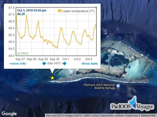
Image File: http://www.pacioos.hawaii.edu/metadata/browse/nss_wqspp_003.png
File Description:
Sample image.
Browse Graphic:

View full image
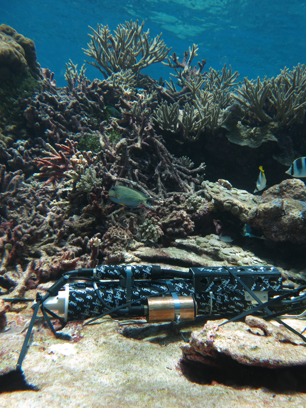
Image File: http://www.pacioos.hawaii.edu/metadata/browse/nss_wqspp_003.2.png
File Description:
Photo of instrument site.
Descriptive Keywords:
Keywords:
Keyword Type:
theme
(MD_KeywordTypeCode)
Keyword: Earth Science Oceans Ocean Chemistry Chlorophyll
Keyword: Earth Science Oceans Ocean Optics Turbidity
Keyword: Earth Science Oceans Ocean Pressure Water Pressure
Keyword: Earth Science Oceans Ocean Temperature Water Temperature
Keyword: Earth Science Oceans Salinity/Density Salinity
Keyword: Earth Science Oceans Water Quality
Keyword Thesaurus:
Citation Information:
Title:
GCMD Science Keywords
Keywords:
Keyword Type:
theme
(MD_KeywordTypeCode)
Keyword: In Situ Ocean-based Platforms OCEAN PLATFORM/OCEAN STATIONS
Keyword Thesaurus:
Citation Information:
Title:
GCMD Platform Keywords
Keywords:
Keyword Type:
theme
(MD_KeywordTypeCode)
Keyword: In Situ/Laboratory Instruments Chemical Meters/Analyzers Fluorometers
Keyword: In Situ/Laboratory Instruments Conductivity Sensors
Keyword: In Situ/Laboratory Instruments Photon/Optical Detectors Turbidity Meters
Keyword: In Situ/Laboratory Instruments Pressure/Height Meters Pressure Sensors
Keyword: In Situ/Laboratory Instruments Profilers/Sounders CTD
Keyword: In Situ/Laboratory Instruments Temperature/Humidity Sensors Temperature Sensors
Keyword Thesaurus:
Citation Information:
Title:
GCMD Instrument Keywords
Keywords:
Keyword Type:
place
(MD_KeywordTypeCode)
Keyword: Ocean Pacific Ocean Central Pacific Ocean Palmyra Atoll
Keyword: Ocean Pacific Ocean Central Pacific Ocean U.S. Minor Outlying Islands (USMOI)
Keyword Thesaurus:
Citation Information:
Title:
GCMD Location Keywords
Keywords:
Keyword Type:
project
(MD_KeywordTypeCode)
Keyword: PacIOOS Pacific Islands Ocean Observing System
Keyword Thesaurus:
Citation Information:
Title:
GCMD Project Keywords
Keywords:
Keyword Type:
dataCenter
(MD_KeywordTypeCode)
Keyword: PacIOOS Pacific Islands Ocean Observing System
Keyword Thesaurus:
Citation Information:
Title:
GCMD Data Center Keywords
Keywords:
Keyword Type:
theme
(MD_KeywordTypeCode)
Keyword: depth
Keyword: latitude
Keyword: longitude
Keyword: mass_concentration_of_chlorophyll_in_sea_water
Keyword: mass_concentration_of_chlorophyll_in_sea_water status_flag
Keyword: sea_water_practical_salinity
Keyword: sea_water_practical_salinity status_flag
Keyword: sea_water_pressure
Keyword: sea_water_pressure status_flag
Keyword: sea_water_temperature
Keyword: sea_water_temperature status_flag
Keyword: sea_water_turbidity
Keyword: sea_water_turbidity status_flag
Keyword: time
Keyword Thesaurus:
Citation Information:
Title:
CF Standard Name Table v71
Aggregation Information:
Aggregate Dataset Name:
Citation Information:
Title:
Pacific Islands Ocean Observing System (PacIOOS)
Association Type: largerWorkCitation (DS_AssociationTypeCode)
Initiative Type: project (DS_InitiativeTypeCode)
Aggregation Information:
Aggregate Dataset Identifier:
Code:
TimeSeries
Authority:
Unidata Common Data Model
Association Type: largerWorkCitation (DS_AssociationTypeCode)
Initiative Type: project (DS_InitiativeTypeCode)
Resource Constraints:
Legal Constraints:
Use Limitation:
The data may be used and redistributed for free but is not intended for legal use, since it may contain inaccuracies. Neither the data Contributor, University of Hawaii, PacIOOS, NOAA, State of Hawaii nor the United States Government, nor any of their employees or contractors, makes any warranty, express or implied, including warranties of merchantability and fitness for a particular purpose, or assumes any legal liability for the accuracy, completeness, or usefulness, of this information.
Language:
eng
Topic Category:
environment
Topic Category:
oceans
Extent Information:
Spatial Temporal Extent:
Geographic Element:
Bounding Coordinates:
á
Westbound Longitude: -162.1103░
Eastbound Longitude: -162.1103░
Southbound Latitude: 5.871░
Northbound Latitude: 5.871░
Temporal Element:
Time Period:
Begin Position: October 2, 2017
End Position: October 4, 2018
Vertical Element:
Minimum Value: 4.0 m
Maximum Value: 4.0 m
Coordinate Reference System (CRS): missing
Services:
Service Identification:
Identifier: ERDDAP-tabledap
Service Type:
ERDDAP tabledap
Contains Operation:
Operation Name:
ERDDAPtabledapDatasetQueryAndAccess
Online Resource:
Linkage: https://pae-paha.pacioos.hawaii.edu/erddap/tabledap/nss_wqspp_003
Name:
ERDDAP-tabledap
Protocol:
ERDDAP:tabledap
Description:
ERDDAP's tabledap service (a flavor of OPeNDAP) for tabular (sequence) data. Add different extensions (e.g., .html, .graph, .das, .dds) to the base URL for different purposes.
Function:
download
(CI_OnLineFunctionCode)
Services:
Service Identification:
Identifier: OPeNDAP
Service Type:
OPeNDAP
Contains Operation:
Operation Name:
OPeNDAPDatasetQueryAndAccess
Online Resource:
Linkage: https://pae-paha.pacioos.hawaii.edu/erddap/tabledap/nss_wqspp_003
Name:
OPeNDAP
Protocol:
OPeNDAP:OPeNDAP
Description:
An OPeNDAP service for tabular (sequence) data. Add different extensions (e.g., .html, .das, .dds) to the base URL for different purposes.
Function:
download
(CI_OnLineFunctionCode)
Back to Top