Dataset Identifier:
pac_ocs_usa_contiguous_zone
Citation:
Citation Information:
Title: Contiguous Zone - U.S.-Affiliated Pacifc Islands
Originator: NOAA Office of Coast Survey (OCS)
Publication Date: January 25, 2016
Description:
Abstract:
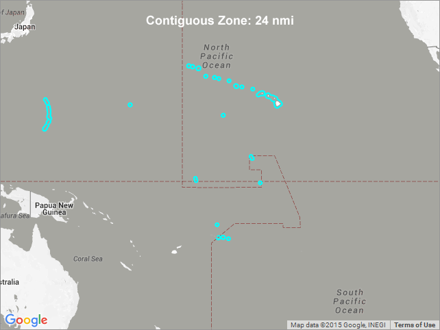
These boundaries represent the contiguous zone for U.S.-affiliated Pacific Islands, including Hawaii, American Samoa, the Commonwealth of the Northern Mariana Islands (CNMI), Guam, as well as the U.S. Minor Outlying Islands of Baker Island, Howland Island, Jarvis Island, Johnston Atoll, Kingman Reef, Midway Atoll, Palmyra Atoll, and Wake Island.
The contiguous zone is a band of water extending from the outer edge of the territorial sea to up to 24 nautical miles from the coastal baseline (usually the mean low-water mark), within which a state can exert limited control for the purpose of preventing or punishing "infringement of its customs, fiscal, immigration or sanitary laws and regulations within its territory or territorial sea". However, unlike the Territorial Sea there is no standard rule for resolving such conflicts, and the states in question must negotiate their own compromise.
Purpose: PacIOOS provides timely, reliable, and accurate ocean information to support a safe, clean, productive ocean and resilient coastal zone in the U.S. Pacific Islands region.
Spatial Domain:
Bounding Coordinates:
West Bounding Coordinate: -178.82837°
East Bounding Coordinate: 167.08101°
North Bounding Coordinate: 28.85760°
South Bounding Coordinate: -14.96169°
Keywords:
Theme:
Theme Keyword Thesaurus: GCMD Science Keywords
Keyword: Earth Science Human Dimensions Boundaries
Keyword: Earth Science Human Dimensions Boundaries Political Divisions Country Boundaries
Place:
Place Keyword Thesaurus: GCMD Location Keywords
Place Keyword: Continent North America United States Of America Hawaii
Place Keyword: Geographic Region Oceania
Place Keyword: Ocean Pacific Ocean
Place Keyword: Ocean Pacific Ocean Central Pacific Ocean Baker Island
Place Keyword: Ocean Pacific Ocean Central Pacific Ocean Hawaiian Islands
Place Keyword: Ocean Pacific Ocean Central Pacific Ocean Howland Island
Place Keyword: Ocean Pacific Ocean Central Pacific Ocean Jarvis Island
Place Keyword: Ocean Pacific Ocean Central Pacific Ocean Johnston Atoll
Place Keyword: Ocean Pacific Ocean Central Pacific Ocean Kingman Reef
Place Keyword: Ocean Pacific Ocean Central Pacific Ocean Palmyra Atoll
Place Keyword: Ocean Pacific Ocean Central Pacific Ocean Wake Island
Place Keyword: Ocean Pacific Ocean South Pacific Ocean Polynesia American Samoa
Place Keyword: Ocean Pacific Ocean Western Pacific Ocean Micronesia Guam
Place Keyword: Ocean Pacific Ocean Western Pacific Ocean Micronesia Northern Mariana Islands Commonwealth of the Northern Mariana Islands (CNMI)
Access Constraints:
None
Use Constraints:
Use Limitation: The data may be used and redistributed for free but is not intended for legal use, since it may contain inaccuracies. Neither the data Contributor, University of Hawaii, PacIOOS, NOAA, State of Hawaii nor the United States Government, nor any of their employees or contractors, makes any warranty, express or implied, including warranties of merchantability and fitness for a particular purpose, or assumes any legal liability for the accuracy, completeness, or usefulness, of this information.
Point of Contact:
Contact Information:
Contact Organization Primary:
Contact Organization: NOAA Office of Coast Survey (OCS)
Contact Electronic Mail Address: ocs.webmaster@noaa.gov
Data Set Credit:
The Pacific Islands Ocean Observing System (PacIOOS) is funded through the National Oceanic and Atmospheric Administration (NOAA) as a Regional Association within the U.S. Integrated Ocean Observing System (IOOS). PacIOOS is coordinated by the University of Hawaii School of Ocean and Earth Science and Technology (SOEST).
Browse Graphic:
View full image
Browse Graphic File Name: http://www.pacioos.hawaii.edu/metadata/browse/pac_ocs_usa_contiguous_zone.png
Browse Graphic File Description:
Sample image.
Browse Graphic File Type: PNG
Back to Top
