Citation:
Citation Information:
Title:
Regional Ocean Modeling System (ROMS): Main Hawaiian Islands: Data Assimilating
Date:
Date: June 1, 2010
Date Type:
creation
(CI_DateTypeCode)
Identifier:
Code:
roms_hiig_assim
Authority:
org.pacioos
Responsible Party:
Individual Name:
Brian S. Powell
Organization Name:
University of Hawaii at Manoa
Contact:
Contact Address:
Email:
powellb@hawaii.edu
Online Resource:
Linkage: http://www.soest.hawaii.edu/oceanography/faculty/powell.html
Protocol:
http
Function:
information
(CI_OnLineFunctionCode)
Contact Role:
originator
(CI_RoleCode)
Responsible Party:
Organization Name:
Pacific Islands Ocean Observing System (PacIOOS)
Contact:
Contact Address:
Email:
info@pacioos.org
Online Resource:
Linkage: http://pacioos.org
Protocol:
http
Function:
information
(CI_OnLineFunctionCode)
Contact Role:
publisher
(CI_RoleCode)
Suggested data citation: Powell, B.S. 2010, updated 2015. Regional Ocean Modeling System (ROMS): Main Hawaiian Islands: Data Assimilating. [Indicate temporal subset used.] Distributed by the Pacific Islands Ocean Observing System (PacIOOS). http://pacioos.org/metadata/roms_hiig_assim.html. Accessed [date].
Abstract:
Regional Ocean Modeling System (ROMS) 3-day, 3-hourly data assimilating hindcast for the region surrounding the main Hawaiian Islands at approximately 4-km resolution. Boundary conditions provided by the global, 1/12-degree (~9-km) HYbrid Coordinate Ocean Model (HYCOM). Atmospheric forcing generated by the Weather Research and Forecasting (WRF) model for the region surrounding the main Hawaiian Islands (wrf_hi) at approximately 6-km resolution. Tide forcing uses the Oregon State University (OSU) Tidal Prediction Software (OTPS) TOPEX/Poseidon global inverse solution (TPXO) to derive barotropic tidal elevation and velocity. Data are assimilated over the previous 3 days using all available observations to improve the model estimate of current ocean state (its nowcast). Assimilated observations may include satellite-based sea surface temperatures from MODIS, AVHRR, or OSTIA; satellite-based sea surface height from AVISO; surface currents from PacIOOS high-frequency radios (HFR); and in-situ water temperature and salinity profiles from ARGO floats and ocean glider autonomous underwater vehicles (AUV). While considerable effort has been made to implement all model components in a thorough, correct, and accurate manner, numerous sources of error are possible. As such, please use these data with the caution appropriate for any ocean related activity.
Purpose:
PacIOOS provides timely, reliable, and accurate ocean information to support a safe, clean, productive ocean and resilient coastal zone in the U.S. Pacific Islands region.
Credit:
The Pacific Islands Ocean Observing System (PacIOOS) is funded through the National Oceanic and Atmospheric Administration (NOAA) as a Regional Association within the U.S. Integrated Ocean Observing System (IOOS). PacIOOS is coordinated by the University of Hawaii School of Ocean and Earth Science and Technology (SOEST).
Point of Contact:
Responsible Party:
Individual Name:
Brian S. Powell
Organization Name:
University of Hawaii at Manoa
Contact:
Contact Address:
Email:
powellb@hawaii.edu
Online Resource:
Linkage: http://www.soest.hawaii.edu/oceanography/faculty/powell.html
Protocol:
http
Function:
information
(CI_OnLineFunctionCode)
Contact Role:
pointOfContact
(CI_RoleCode)
Browse Graphic:
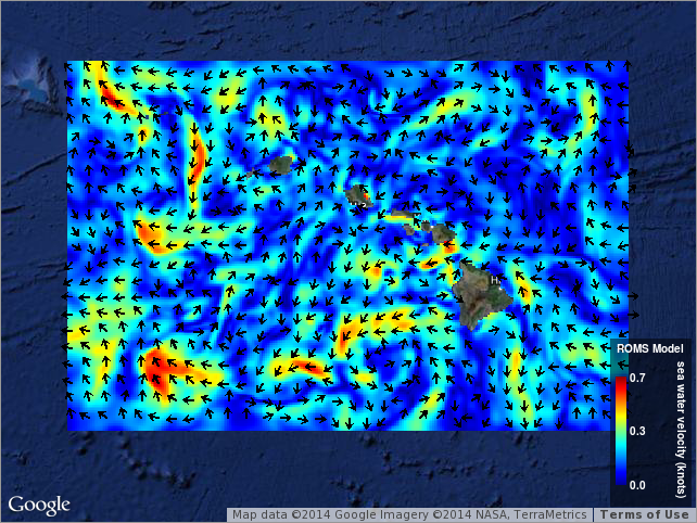
View full image
Image File: http://www.pacioos.hawaii.edu/metadata/browse/roms_hiig_assim.png
File Description:
Sample image.
Descriptive Keywords:
Keywords:
Keyword Type:
theme
(MD_KeywordTypeCode)
Keyword: Earth Science Oceans Ocean Circulation Ocean Currents
Keyword: Earth Science Oceans Ocean Temperature Potential Temperature
Keyword: Earth Science Oceans Salinity/Density Salinity
Keyword: Earth Science Oceans Sea Surface Topography Sea Surface Height
Keyword: Earth Science Services Models Ocean General Circulation Models (OGCM)/Regional Ocean Models
Keyword: Earth Science Services Models Weather Research/Forecast Models
Keyword Thesaurus:
Citation Information:
Title:
GCMD Science Keywords
Keywords:
Keyword Type:
theme
(MD_KeywordTypeCode)
Keyword: Models/Analyses Operational Models
Keyword Thesaurus:
Citation Information:
Title:
GCMD Platform Keywords
Keywords:
Keyword Type:
theme
(MD_KeywordTypeCode)
Keyword: Not Applicable Not Applicable
Keyword Thesaurus:
Citation Information:
Title:
GCMD Instrument Keywords
Keywords:
Keyword Type:
place
(MD_KeywordTypeCode)
Keyword: Continent North America United States Of America Hawaii
Keyword: Ocean Pacific Ocean Central Pacific Ocean Hawaiian Islands
Keyword Thesaurus:
Citation Information:
Title:
GCMD Location Keywords
Keywords:
Keyword Type:
project
(MD_KeywordTypeCode)
Keyword: PacIOOS Pacific Islands Ocean Observing System
Keyword Thesaurus:
Citation Information:
Title:
GCMD Project Keywords
Keywords:
Keyword Type:
dataCenter
(MD_KeywordTypeCode)
Keyword: PacIOOS Pacific Islands Ocean Observing System
Keyword Thesaurus:
Citation Information:
Title:
GCMD Data Center Keywords
Keywords:
Keyword Type:
theme
(MD_KeywordTypeCode)
Keyword: depth
Keyword: eastward_sea_water_velocity
Keyword: forecast_period
Keyword: forecast_reference_time
Keyword: latitude
Keyword: longitude
Keyword: northward_sea_water_velocity
Keyword: sea_binary_mask
Keyword: sea_surface_height
Keyword: sea_water_potential_temperature
Keyword: sea_water_salinity
Keyword: time
Keyword Thesaurus:
Citation Information:
Title:
CF Standard Name Table v39
Aggregation Information:
Aggregate Dataset Name:
Citation Information:
Title:
Pacific Islands Ocean Observing System (PacIOOS)
Association Type: largerWorkCitation (DS_AssociationTypeCode)
Initiative Type: project (DS_InitiativeTypeCode)
Aggregation Information:
Aggregate Dataset Identifier:
Code:
Grid
Authority:
Unidata Common Data Model
Association Type: largerWorkCitation (DS_AssociationTypeCode)
Initiative Type: project (DS_InitiativeTypeCode)
Resource Constraints:
Legal Constraints:
Use Limitation:
The data may be used and redistributed for free but is not intended for legal use, since it may contain inaccuracies. Neither the data Contributor, University of Hawaii, PacIOOS, NOAA, State of Hawaii nor the United States Government, nor any of their employees or contractors, makes any warranty, express or implied, including warranties of merchantability and fitness for a particular purpose, or assumes any legal liability for the accuracy, completeness, or usefulness, of this information.
Language:
eng
Topic Category:
oceans
Extent Information:
Spatial Temporal Extent:
Geographic Element:
Bounding Coordinates:
Westbound Longitude: -163.8307°
Eastbound Longitude: -152.5193°
Southbound Latitude: 17.01843°
Northbound Latitude: 23.98239°
Temporal Element:
Time Period:
Description: seconds
Begin Position: April 12, 2015
End Position: July 28, 2025
Vertical Element:
Minimum Value:
-0.25
m
Maximum Value:
-5500
m
Coordinate Reference System (CRS): missing
Services:
Service Identification:
Identifier: OPeNDAP
Service Type:
THREDDS OPeNDAP
Contains Operation:
Operation Name:
OPeNDAP Client Access
Online Resource:
Linkage: https://pae-paha.pacioos.hawaii.edu/thredds/dodsC/roms_hiig_assim/ROMS_Hawaii_Regional_Ocean_Model_Assimilation_best.ncd
Name:
OPeNDAP
Protocol:
OPeNDAP:OPeNDAP
Description:
THREDDS OPeNDAP
Function:
download
(CI_OnLineFunctionCode)
Services:
Service Identification:
Identifier: OGC-WCS
Service Type:
Open Geospatial Consortium Web Coverage Service (WCS)
Contains Operation:
Operation Name:
GetCapabilities
Online Resource:
Linkage: https://pae-paha.pacioos.hawaii.edu/thredds/wcs/roms_hiig_assim/ROMS_Hawaii_Regional_Ocean_Model_Assimilation_best.ncd?service=WCS&version=1.0.0&request=GetCapabilities
Name:
OGC-WCS
Protocol:
OGC:WCS
Description:
Open Geospatial Consortium Web Coverage Service (WCS)
Function:
download
(CI_OnLineFunctionCode)
Services:
Service Identification:
Identifier: OGC-WMS
Service Type:
Open Geospatial Consortium Web Map Service (WMS)
Contains Operation:
Operation Name:
GetCapabilities
Online Resource:
Linkage: https://pae-paha.pacioos.hawaii.edu/thredds/wms/roms_hiig_assim/ROMS_Hawaii_Regional_Ocean_Model_Assimilation_best.ncd?service=WMS&version=1.3.0&request=GetCapabilities
Name:
OGC-WMS
Protocol:
OGC:WMS
Description:
Open Geospatial Consortium Web Map Service (WMS)
Function:
download
(CI_OnLineFunctionCode)
Services:
Service Identification:
Identifier: THREDDS_NetCDF_Subset
Service Type:
THREDDS NetCDF Subset Service
Contains Operation:
Operation Name:
NetCDFSubsetService
Online Resource:
Linkage: https://pae-paha.pacioos.hawaii.edu/thredds/ncss/roms_hiig_assim/ROMS_Hawaii_Regional_Ocean_Model_Assimilation_best.ncd/dataset.html
Name:
THREDDS_NetCDF_Subset
Protocol:
UNIDATA:NCSS
Description:
THREDDS NetCDF Subset Service
Function:
download
(CI_OnLineFunctionCode)
Back to Top
