Data Services Metadata Data Search

SRTM30+ Global 1-km Digital Elevation Model (DEM): Version 11: Land Surface

Identification Information

Dataset Identifier:

srtm30plus_v11_land

Citation:

Citation Information:

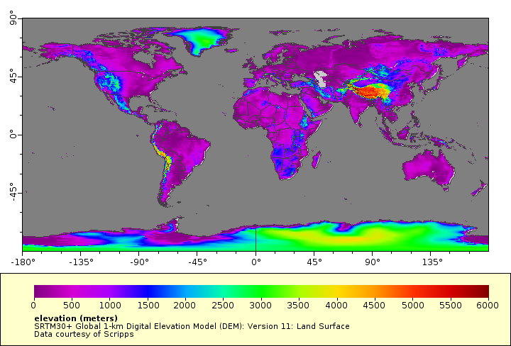
Title: SRTM30+ Global 1-km Digital Elevation Model (DEM): Version 11: Land Surface
Originator: David T. Sandwell
Originator: Walter H.F. Smith
Originator: Joseph J. Becker
Publication Date: November 29, 2014

Description:

Abstract:

A global 1-km resolution land surface digital elevation model (DEM) derived from U.S. Geological Survey (USGS) 30 arc-second SRTM30 gridded DEM data created from the NASA Shuttle Radar Topography Mission (SRTM). GTOPO30 data are used for high latitudes where SRTM data are not available. For a grayscale hillshade image layer of this dataset, see "world_srtm30plus_dem1km_hillshade" in the distribution links listed in the metadata.

Purpose: PacIOOS provides timely, reliable, and accurate ocean information to support a safe, clean, productive ocean and resilient coastal zone in the U.S. Pacific Islands region.

Spatial Domain:

Bounding Coordinates:


West Bounding Coordinate: -180.0°
East Bounding Coordinate: 180.0°
North Bounding Coordinate: 90.0°
South Bounding Coordinate: -90.0°

Bounding Altitudes:

Altitude Minimum: 0.0
Altitude Maximum: 7729.0
Altitude Distance Units: m

Keywords:

Theme:

Theme Keyword Thesaurus: GCMD Science Keywords
Keyword: Earth Science Land Surface Topography Terrain Elevation Digital Elevation/Terrain Model (DEM)

Theme:

Theme Keyword Thesaurus: GCMD Platform Keywords
Keyword: Models/Analyses DEM Digital Elevation Model
Keyword: Space Stations/Manned Spacecraft Space Shuttle

Theme:

Theme Keyword Thesaurus: GCMD Instrument Keywords
Keyword: Earth Remote Sensing Instruments Active Remote Sensing Imaging Radars SRTM Shuttle Radar Topography Mission

Theme:

Theme Keyword Thesaurus: CF Standard Name Table v39
Keyword: height
Keyword: latitude
Keyword: longitude

Place:

Place Keyword Thesaurus: GCMD Location Keywords
Place Keyword: Geographic Region Global Land

Access Constraints:

None

Use Constraints:

Use Limitation: David T. Sandwell, Walter H. F. Smith, and Joseph J. Becker Copyright 2009. The Regents of the University of California. All Rights Reserved. Permission to copy, modify and distribute any part of this gridded bathymetry at 30 second resolution for educational, research and non-profit purposes, without fee, and without a written agreement is hereby granted, provided that the above copyright notice, this paragraph and the following three paragraphs appear in all copies. Those desiring to incorporate this global bathymetry into commercial products or use for commercial purposes should contact the Technology Transfer and Intellectual Property Services, University of California, San Diego, 9500 Gilman Drive, Mail Code 0910, La Jolla, CA 92093-0910, Ph: (858) 534-5815, FAX: (858) 534-7345, E-MAIL:invent@ucsd.edu. IN NO EVENT SHALL THE UNIVERSITY OF CALIFORNIA BE LIABLE TO ANY PARTY FOR DIRECT, INDIRECT, SPECIAL, INCIDENTAL, OR CONSEQUENTIAL DAMAGES, INCLUDING LOST PROFITS, ARISING OUT OF THE USE OF THIS global bathymetry, EVEN IF THE UNIVERSITY OF CALIFORNIA HAS BEEN ADVISED OF THE POSSIBILITY OF SUCH DAMAGE. THE global bathymetry PROVIDED HEREIN IS ON AN 'AS IS' BASIS, AND THE UNIVERSITY OF CALIFORNIA HAS NO OBLIGATION TO PROVIDE MAINTENANCE, SUPPORT, UPDATES, ENHANCEMENTS, OR MODIFICATIONS. THE UNIVERSITY OF CALIFORNIA MAKES NO REPRESENTATIONS AND EXTENDS NO WARRANTIES OF ANY KIND, EITHER IMPLIED OR EXPRESS, INCLUDING, BUT NOT LIMITED TO, THE IMPLIED WARRANTIES OF MERCHANTABILITY OR FITNESS FOR A PARTICULAR PURPOSE, OR THAT THE USE OF THE global bathymetry WILL NOT INFRINGE ANY PATENT, TRADEMARK OR OTHER RIGHTS.

Point of Contact:

Contact Information:

Contact Organization Primary:

Contact Organization: Scripps Institution of Oceanography (SIO)
Contact Person: David T. Sandwell

Contact Electronic Mail Address:  dsandwell@ucsd.edu

Data Set Credit:

The Pacific Islands Ocean Observing System (PacIOOS) is funded through the National Oceanic and Atmospheric Administration (NOAA) as a Regional Association within the U.S. Integrated Ocean Observing System (IOOS). PacIOOS is coordinated by the University of Hawaii School of Ocean and Earth Science and Technology (SOEST).

Browse Graphic:


View full image

Browse Graphic File Name: http://www.pacioos.hawaii.edu/metadata/browse/srtm30plus_v11_land.png

Browse Graphic File Description:

Sample image.

Browse Graphic File Type: PNG

Back to Top

Distribution Information

Distributor:

Contact Information:

Contact Organization Primary:

Contact Organization: Pacific Islands Ocean Observing System (PacIOOS)

Contact Electronic Mail Address:  info@pacioos.org

Standard Order Process:

Digital Form:

Digital Transfer Information:

Format Name: THREDDS OPeNDAP

Digital Transfer Option:

Online Option:

Computer Contact Information:

Network Address:

Network Resource Name: https://pae-paha.pacioos.hawaii.edu/thredds/dodsC/srtm30plus_v11_land

Digital Form:

Digital Transfer Information:

Format Name: Open Geospatial Consortium Web Coverage Service (WCS)

Digital Transfer Option:

Online Option:

Computer Contact Information:

Network Address:

Network Resource Name: https://pae-paha.pacioos.hawaii.edu/thredds/wcs/srtm30plus_v11_land?service=WCS&version=1.0.0&request=GetCapabilities

Digital Form:

Digital Transfer Information:

Format Name: Open Geospatial Consortium Web Map Service (WMS)

Digital Transfer Option:

Online Option:

Computer Contact Information:

Network Address:

Network Resource Name: https://pae-paha.pacioos.hawaii.edu/thredds/wms/srtm30plus_v11_land?service=WMS&version=1.3.0&request=GetCapabilities

Digital Form:

Digital Transfer Information:

Format Name: THREDDS NetCDF Subset Service

Digital Transfer Option:

Online Option:

Computer Contact Information:

Network Address:

Network Resource Name: https://pae-paha.pacioos.hawaii.edu/thredds/ncss/srtm30plus_v11_land/dataset.html

Digital Form:

Digital Transfer Information:

Format Name: THREDDS Catalog

Format Information Content:

This URL provides a catalog page for this dataset within THREDDS Data Server (TDS).

Digital Transfer Option:

Online Option:

Computer Contact Information:

Network Address:

Network Resource Name: https://pae-paha.pacioos.hawaii.edu/thredds/dem.html?dataset=srtm30plus_v11_land

Digital Form:

Digital Transfer Information:

Format Name: File Information

Format Information Content:

This URL provides a standard OPeNDAP html interface for selecting data from this dataset. Change the extension to .info for a description of the dataset.

Digital Transfer Option:

Online Option:

Computer Contact Information:

Network Address:

Network Resource Name: https://pae-paha.pacioos.hawaii.edu/thredds/dodsC/srtm30plus_v11_land.html

Digital Form:

Digital Transfer Information:

Format Name: PacIOOS Voyager (Google Maps API)

Format Information Content:

This URL provides a viewer and/or data access for this dataset.

Digital Transfer Option:

Online Option:

Computer Contact Information:

Network Address:

Network Resource Name: http://pacioos.org/voyager/index.html?b=-85.051129%2C-180%2C85.051129%2C180&o=dem:1:ft:d21

Digital Form:

Digital Transfer Information:

Format Name: ERDDAP

Format Information Content:

This URL provides a viewer and/or data access for this dataset.

Digital Transfer Option:

Online Option:

Computer Contact Information:

Network Address:

Network Resource Name: https://pae-paha.pacioos.hawaii.edu/erddap/griddap/srtm30plus_v11_land

Digital Form:

Digital Transfer Information:

Format Name: Scripps Institution of Oceanography

Format Information Content:

This URL provides a viewer and/or data access for this dataset.

Digital Transfer Option:

Online Option:

Computer Contact Information:

Network Address:

Network Resource Name: https://topex.ucsd.edu/WWW_html/srtm30_plus.html

Digital Form:

Digital Transfer Information:

Format Name: Related URL

Format Information Content:

This URL provides additional information related to this dataset.

Digital Transfer Option:

Online Option:

Computer Contact Information:

Network Address:

Network Resource Name: http://pacioos.org/metadata/world_srtm30plus_dem1km_hillshade.html

Fees: None specified

Back to Top

Metadata Reference Information

Metadata Date:

January 24, 2023

Metadata Contact:

Contact Information:

Contact Person Primary:

Contact Organization: Scripps Institution of Oceanography (SIO)

Contact Electronic Mail Address:  dsandwell@ucsd.edu

Metadata Standard Name:

Content Standard for Digital Geospatial Metadata: Extensions for Remote Sensing Metadata

Metadata Standard Version:

FGDC-STD-012-2002

Back to Top

Metadata Views

FGDC Text-Only

Federal Geographic Data Committee (FGDC) in plain text

FGDC XML

Federal Geographic Data Committee (FGDC) in Extensible Markup Language (XML)

ISO HTML

International Organization for Standardization (ISO) 19115:2003 Geographic Information Metadata