Dataset Identifier:
tide_mhi
Citation:
Citation Information:
Title: Tide Model for the Hawaiian Islands: Main NW Islands
Originator: Glenn S. Carter
Publication Date: November 10, 2010
Description:
Abstract:
Tide model for the Hawaiian Islands. The model is based on climatological stratification, but 64 harmonics are used to model the full-depth baroclinic tides. The model has been run at 1km resolution, hourly, through the end of 2026. Due to computing limitations, the model grid is divided into two pieces, one for the Northwestern main Hawaiian Islands (Kauai, Oahu, Maui) and the other for the Big Island. While considerable effort has been made to implement all model components in a thorough, correct, and accurate manner, numerous sources of error are possible. As such, please use this output with the caution appropriate for any ocean related activity.
Purpose: PacIOOS provides timely, reliable, and accurate ocean information to support a safe, clean, productive ocean and resilient coastal zone in the U.S. Pacific Islands region.
Time Period of Content:
Time Period Information:
Range of Dates/Times:
Beginning Date: December 1, 2025
Ending Date: December 31, 2026
Currentness Reference: Unknown
Spatial Domain:
Bounding Coordinates:
West Bounding Coordinate: -160.69°
East Bounding Coordinate: -155.49°
North Bounding Coordinate: 22.89°
South Bounding Coordinate: 20.48°
Bounding Altitudes:
Altitude Minimum: 0
Altitude Maximum: 100
Altitude Distance Units:
m
Keywords:
Theme:
Theme Keyword Thesaurus: GCMD Science Keywords
Keyword: Earth Science Oceans Ocean Circulation Ocean Currents
Keyword: Earth Science Oceans Sea Surface Topography Sea Surface Height
Keyword: Earth Science Oceans Tides Tidal Height
Keyword: Earth Science Services Models Ocean General Circulation Models (OGCM)/Regional Ocean Models
Keyword: Earth Science Services Models Weather Research/Forecast Models
Theme:
Theme Keyword Thesaurus: GCMD Platform Keywords
Keyword: Models/Analyses Operational Models
Theme:
Theme Keyword Thesaurus: GCMD Instrument Keywords
Keyword: Not Applicable Not Applicable
Theme:
Theme Keyword Thesaurus: CF Standard Name Table v39
Keyword: eastward_sea_water_velocity
Keyword: latitude
Keyword: longitude
Keyword: northward_sea_water_velocity
Keyword: sea_surface_height
Keyword: time
Place:
Place Keyword Thesaurus: GCMD Location Keywords
Place Keyword: Continent North America United States Of America Hawaii
Place Keyword: Ocean Pacific Ocean Central Pacific Ocean Hawaiian Islands Kahoolawe
Place Keyword: Ocean Pacific Ocean Central Pacific Ocean Hawaiian Islands Kauai
Place Keyword: Ocean Pacific Ocean Central Pacific Ocean Hawaiian Islands Lanai
Place Keyword: Ocean Pacific Ocean Central Pacific Ocean Hawaiian Islands Maui
Place Keyword: Ocean Pacific Ocean Central Pacific Ocean Hawaiian Islands Molokai
Place Keyword: Ocean Pacific Ocean Central Pacific Ocean Hawaiian Islands Niihau
Place Keyword: Ocean Pacific Ocean Central Pacific Ocean Hawaiian Islands Oahu
Access Constraints:
None
Use Constraints:
Use Limitation: The data may be used and redistributed for free but is not intended for legal use, since it may contain inaccuracies. Neither the data Contributor, University of Hawaii, PacIOOS, NOAA, State of Hawaii nor the United States Government, nor any of their employees or contractors, makes any warranty, express or implied, including warranties of merchantability and fitness for a particular purpose, or assumes any legal liability for the accuracy, completeness, or usefulness, of this information.
Point of Contact:
Contact Information:
Contact Organization Primary:
Contact Organization: University of Hawaii at Manoa
Contact Person: Glenn S. Carter
Contact Electronic Mail Address: gscarter@hawaii.edu
Data Set Credit:
The Pacific Islands Ocean Observing System (PacIOOS) is funded through the National Oceanic and Atmospheric Administration (NOAA) as a Regional Association within the U.S. Integrated Ocean Observing System (IOOS). PacIOOS is coordinated by the University of Hawaii School of Ocean and Earth Science and Technology (SOEST).
Browse Graphic:
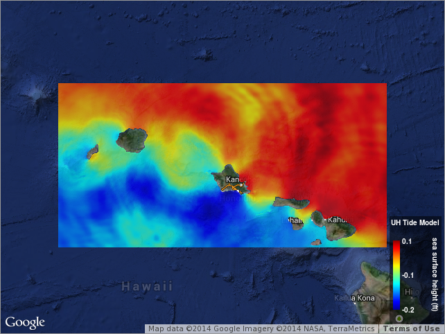
View full image
Browse Graphic File Name: http://www.pacioos.hawaii.edu/metadata/browse/tide_mhi.png
Browse Graphic File Description:
Sample image.
Browse Graphic File Type: PNG
Back to Top
