Citation:
Citation Information:
Title:
Weather Research and Forecasting (WRF) Regional Atmospheric Model: Guam
Date:
Date: June 14, 2013
Date Type:
creation
(CI_DateTypeCode)
Identifier:
Code:
wrf_guam
Authority:
org.pacioos
Responsible Party:
Individual Name:
Yi-Leng Chen
Organization Name:
University of Hawaii at Manoa
Contact:
Contact Address:
Email:
yileng@hawaii.edu
Online Resource:
Linkage: http://www.soest.hawaii.edu/MET/Faculty/chen/chen_index.html
Protocol:
http
Function:
information
(CI_OnLineFunctionCode)
Contact Role:
originator
(CI_RoleCode)
Responsible Party:
Organization Name:
Pacific Islands Ocean Observing System (PacIOOS)
Contact:
Contact Address:
Email:
info@pacioos.org
Online Resource:
Linkage: http://pacioos.org
Protocol:
http
Function:
information
(CI_OnLineFunctionCode)
Contact Role:
publisher
(CI_RoleCode)
Suggested data citation: Chen, Y.-L. 2013, updated 2017. Weather Research and Forecasting (WRF) Regional Atmospheric Model: Guam. [Indicate temporal subset used.] Distributed by the Pacific Islands Ocean Observing System (PacIOOS). http://pacioos.org/metadata/wrf_guam.html. Accessed [date].
Abstract:
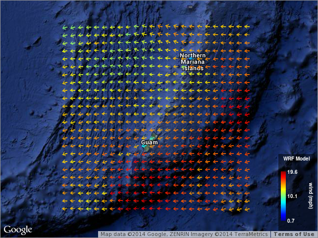
Weather Research and Forecasting (WRF) mesoscale numerical weather prediction model 7-day hourly forecast for the region surrounding the island of Guam at approximately 3-km resolution. Uses the Advanced Research WRF (ARW) dynamical solver developed and maintained by the Mesoscale and Microscale Meteorology Division of the National Center for Atmospheric Research (NCAR). Model runs produced at the University of Hawaii by Yi-Leng Chen.
Purpose:
PacIOOS provides timely, reliable, and accurate ocean information to support a safe, clean, productive ocean and resilient coastal zone in the U.S. Pacific Islands region.
Credit:
The Pacific Islands Ocean Observing System (PacIOOS) is funded through the National Oceanic and Atmospheric Administration (NOAA) as a Regional Association within the U.S. Integrated Ocean Observing System (IOOS). PacIOOS is coordinated by the University of Hawaii School of Ocean and Earth Science and Technology (SOEST).
Point of Contact:
Responsible Party:
Individual Name:
Yi-Leng Chen
Organization Name:
University of Hawaii at Manoa
Contact:
Contact Address:
Email:
yileng@hawaii.edu
Online Resource:
Linkage: http://www.soest.hawaii.edu/MET/Faculty/chen/chen_index.html
Protocol:
http
Function:
information
(CI_OnLineFunctionCode)
Contact Role:
pointOfContact
(CI_RoleCode)
Browse Graphic:
View full image
Image File: http://www.pacioos.hawaii.edu/metadata/browse/wrf_guam.png
File Description:
Sample image.
Descriptive Keywords:
Keywords:
Keyword Type:
theme
(MD_KeywordTypeCode)
Keyword: Earth Science Atmosphere Atmospheric Pressure Surface Pressure
Keyword: Earth Science Atmosphere Atmospheric Radiation Longwave Radiation
Keyword: Earth Science Atmosphere Atmospheric Radiation Shortwave Radiation
Keyword: Earth Science Atmosphere Atmospheric Temperature Surface Air Temperature
Keyword: Earth Science Atmosphere Atmospheric Water Vapor Humidity
Keyword: Earth Science Atmosphere Atmospheric Winds Surface Winds
Keyword: Earth Science Atmosphere Precipitation Rain
Keyword: Earth Science Services Models Weather Research/Forecast Models
Keyword Thesaurus:
Citation Information:
Title:
GCMD Science Keywords
Keywords:
Keyword Type:
theme
(MD_KeywordTypeCode)
Keyword: Models/Analyses Operational Models
Keyword Thesaurus:
Citation Information:
Title:
GCMD Platform Keywords
Keywords:
Keyword Type:
theme
(MD_KeywordTypeCode)
Keyword: Not Applicable Not Applicable
Keyword Thesaurus:
Citation Information:
Title:
GCMD Instrument Keywords
Keywords:
Keyword Type:
place
(MD_KeywordTypeCode)
Keyword: Ocean Pacific Ocean Western Pacific Ocean Micronesia Guam
Keyword: Ocean Pacific Ocean Western Pacific Ocean Micronesia Northern Mariana Islands Commonwealth of the Northern Mariana Islands (CNMI)
Keyword Thesaurus:
Citation Information:
Title:
GCMD Location Keywords
Keywords:
Keyword Type:
project
(MD_KeywordTypeCode)
Keyword: PacIOOS Pacific Islands Ocean Observing System
Keyword Thesaurus:
Citation Information:
Title:
GCMD Project Keywords
Keywords:
Keyword Type:
dataCenter
(MD_KeywordTypeCode)
Keyword: PacIOOS Pacific Islands Ocean Observing System
Keyword Thesaurus:
Citation Information:
Title:
GCMD Data Center Keywords
Keywords:
Keyword Type:
theme
(MD_KeywordTypeCode)
Keyword: air_temperature
Keyword: eastward_wind
Keyword: forecast_period
Keyword: forecast_reference_time
Keyword: latitude
Keyword: longitude
Keyword: northward_wind
Keyword: precipitation_flux
Keyword: relative_humidity
Keyword: surface_air_pressure
Keyword: surface_downwelling_shortwave_flux
Keyword: surface_net_downward_longwave_flux
Keyword: time
Keyword Thesaurus:
Citation Information:
Title:
CF Standard Name Table v39
Aggregation Information:
Aggregate Dataset Name:
Citation Information:
Title:
Pacific Islands Ocean Observing System (PacIOOS)
Association Type: largerWorkCitation (DS_AssociationTypeCode)
Initiative Type: project (DS_InitiativeTypeCode)
Aggregation Information:
Aggregate Dataset Identifier:
Code:
Grid
Authority:
Unidata Common Data Model
Association Type: largerWorkCitation (DS_AssociationTypeCode)
Initiative Type: project (DS_InitiativeTypeCode)
Resource Constraints:
Legal Constraints:
Use Limitation:
The data may be used and redistributed for free but is not intended for legal use, since it may contain inaccuracies. Neither the data Contributor, University of Hawaii, PacIOOS, NOAA, State of Hawaii nor the United States Government, nor any of their employees or contractors, makes any warranty, express or implied, including warranties of merchantability and fitness for a particular purpose, or assumes any legal liability for the accuracy, completeness, or usefulness, of this information.
Language:
eng
Topic Category:
climatologyMeteorologyAtmosphere
Extent Information:
Spatial Temporal Extent:
Geographic Element:
Bounding Coordinates:
Westbound Longitude: 142.9017°
Eastbound Longitude: 147.07249°
Southbound Latitude: 11.93188°
Northbound Latitude: 15.9786°
Temporal Element:
Time Period:
Description: seconds
Begin Position: June 14, 2013
End Position: June 12, 2025
Services:
Service Identification:
Identifier: OPeNDAP
Service Type:
THREDDS OPeNDAP
Contains Operation:
Operation Name:
OPeNDAP Client Access
Online Resource:
Linkage: https://pae-paha.pacioos.hawaii.edu/thredds/dodsC/wrf_guam/WRF_Guam_Regional_Atmospheric_Model_best.ncd
Name:
OPeNDAP
Protocol:
OPeNDAP:OPeNDAP
Description:
THREDDS OPeNDAP
Function:
download
(CI_OnLineFunctionCode)
Services:
Service Identification:
Identifier: OGC-WMS
Service Type:
Open Geospatial Consortium Web Map Service (WMS)
Contains Operation:
Operation Name:
GetCapabilities
Online Resource:
Linkage: https://pae-paha.pacioos.hawaii.edu/thredds/wms/wrf_guam/WRF_Guam_Regional_Atmospheric_Model_best.ncd?service=WMS&version=1.3.0&request=GetCapabilities
Name:
OGC-WMS
Protocol:
OGC:WMS
Description:
Open Geospatial Consortium Web Map Service (WMS)
Function:
download
(CI_OnLineFunctionCode)
Services:
Service Identification:
Identifier: THREDDS_NetCDF_Subset
Service Type:
THREDDS NetCDF Subset Service
Contains Operation:
Operation Name:
NetCDFSubsetService
Online Resource:
Linkage: https://pae-paha.pacioos.hawaii.edu/thredds/ncss/wrf_guam/WRF_Guam_Regional_Atmospheric_Model_best.ncd/dataset.html
Name:
THREDDS_NetCDF_Subset
Protocol:
UNIDATA:NCSS
Description:
THREDDS NetCDF Subset Service
Function:
download
(CI_OnLineFunctionCode)
Back to Top
