Citation:
Citation Information:
Title:
NOAA Coral Reef Watch Operational Daily Near-Real-Time Global 5-km Satellite Coral Bleaching Monitoring Products
Date:
Date: May 19, 2017
Date Type:
creation
(CI_DateTypeCode)
Edition:
3.1
Identifier:
Code:
dhw_5km
Authority:
org.pacioos
Responsible Party:
Organization Name:
NOAA Coral Reef Watch (CRW)
Contact:
Contact Address:
Email:
coralreefwatch@noaa.gov
Online Resource:
Linkage: https://coralreefwatch.noaa.gov
Protocol:
http
Function:
information
(CI_OnLineFunctionCode)
Contact Role:
originator
(CI_RoleCode)
Responsible Party:
Organization Name:
Pacific Islands Ocean Observing System (PacIOOS)
Contact:
Contact Address:
Email:
info@pacioos.org
Online Resource:
Linkage: http://pacioos.org
Protocol:
http
Function:
information
(CI_OnLineFunctionCode)
Contact Role:
publisher
(CI_RoleCode)
Suggested data citation: NOAA Coral Reef Watch (CRW). 2017, updated 2020. NOAA Coral Reef Watch Operational Daily Near-Real-Time Global 5-km Satellite Coral Bleaching Monitoring Products. Version 3.1. [Indicate temporal subset used.] Distributed by the Pacific Islands Ocean Observing System (PacIOOS). http://pacioos.org/metadata/dhw_5km.html. Accessed [date].
Abstract:
Contains a suite of NOAA Coral Reef Watch (CRW) version 3.1 operational global satellite coral bleaching heat stress monitoring products at 5-km resolution produced daily in near real-time, including sea surface temperature (SST), SST anomaly, HotSpot, Degree Heating Week (DHW), and Bleaching Alert Area (BAA). These data are based on CoralTemp Version 1.0, a daily global 5-km sea surface temperature dataset combined from: (1.) NOAA/NESDIS operational near-real-time daily global 5-km geostationary-polar-orbiting (geo-polar) blended night-only SST analysis, (2.) NOAA/NESDIS 2002-2016 reprocessed daily global 5-km geo-polar blended night-only SST analysis, and (3.) United Kingdom Met Office 1985-2002 daily global 5-km night-only SST reanalysis of Operational SST and Sea Ice Analysis (OSTIA). The SST anomaly is the difference of SST compared to daily SST climatology. The coral bleaching HotSpot is a special type of sea surface temperature (SST) anomaly and shows the difference of SST compared to a coral bleaching SST threshold climatology. DHW is the accumulation of Coral Bleaching HotSpots over a period of 12 consecutive weeks. The DHW value at any particular location at any particular time is the summation of the product of HotSpot values which are at least 1 deg C above the bleaching threshold SST and their durations in weeks over the most recent 12-week period. One DHW is equivalent to 1 week of SST at 1 deg C above the threshold or 0.5 week of SST at 2 deg C above the threshold, etc. The units for DHW are deg C-weeks, combining the intensity and duration of heat stress into one single number. Based on research at Coral Reef Watch, when the heat stress reaches 4 deg C-weeks, you can expect to see significant coral bleaching, especially in more sensitive species. When heat stress is 8 deg C-weeks or higher, you would likely see widespread bleaching and mortality from the heat stress. Provides the most recent 3 years of data only; for the full time series, see PacIOOS ERDDAP instead.
Purpose:
PacIOOS provides timely, reliable, and accurate ocean information to support a safe, clean, productive ocean and resilient coastal zone in the U.S. Pacific Islands region.
Credit:
NOAA Coral Reef Watch (CRW)
Point of Contact:
Responsible Party:
Organization Name:
NOAA Coral Reef Watch (CRW)
Contact:
Contact Address:
Email:
coralreefwatch@noaa.gov
Online Resource:
Linkage: https://coralreefwatch.noaa.gov
Protocol:
http
Function:
information
(CI_OnLineFunctionCode)
Contact Role:
pointOfContact
(CI_RoleCode)
Browse Graphic:
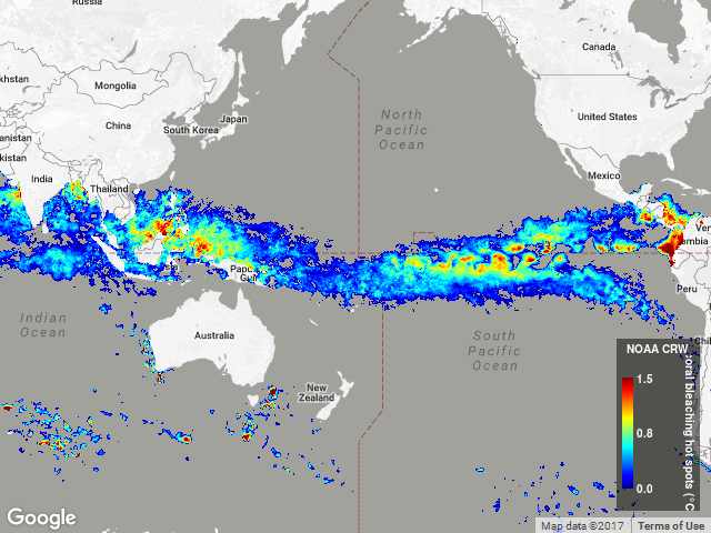
View full image
Image File: http://www.pacioos.hawaii.edu/metadata/browse/dhw_5km.png
File Description:
Sample image.
Descriptive Keywords:
Keywords:
Keyword Type:
theme
(MD_KeywordTypeCode)
Keyword: Earth Science Oceans Coastal Processes Coral Reefs
Keyword: Earth Science Oceans Ocean Temperature Sea Surface Temperature
Keyword Thesaurus:
Citation Information:
Title:
GCMD Science Keywords
Keywords:
Keyword Type:
theme
(MD_KeywordTypeCode)
Keyword: Earth Observation Satellites GOES (Geostationary Operational Environmental Satellite) GOES-13
Keyword: Earth Observation Satellites GOES (Geostationary Operational Environmental Satellite) GOES-15
Keyword: Earth Observation Satellites Himawari Himawari Meteorological Satellites
Keyword: Earth Observation Satellites Joint Polar Satellite System (JPSS) SUOMI-NPP Suomi National Polar-orbiting Partnership
Keyword: Earth Observation Satellites METEOSAT METEOSAT-11
Keyword: Earth Observation Satellites METEOSAT METEOSAT-8
Keyword: Earth Observation Satellites METOP METOP-B Meteorological Operational Satellite - B
Keyword Thesaurus:
Citation Information:
Title:
GCMD Platform Keywords
Keywords:
Keyword Type:
theme
(MD_KeywordTypeCode)
Keyword: Earth Remote Sensing Instruments Passive Remote Sensing Spectrometers/Radiometers Imaging Spectrometers/Radiometers AHI Advanced Himawari Imager
Keyword: Earth Remote Sensing Instruments Passive Remote Sensing Spectrometers/Radiometers Imaging Spectrometers/Radiometers AVHRR Advanced Very High Resolution Radiometer
Keyword: Earth Remote Sensing Instruments Passive Remote Sensing Spectrometers/Radiometers Imaging Spectrometers/Radiometers GOES-13 Imager Geostationary Operational Environmental Satellite 13-Imager
Keyword: Earth Remote Sensing Instruments Passive Remote Sensing Spectrometers/Radiometers Imaging Spectrometers/Radiometers GOES-15 Imager Geostationary Operational Environmental Satellite 15-Imager
Keyword: Earth Remote Sensing Instruments Passive Remote Sensing Spectrometers/Radiometers Imaging Spectrometers/Radiometers SEVIRI Spinning Enhanced Visible and Infrared Imager
Keyword: Earth Remote Sensing Instruments Passive Remote Sensing Spectrometers/Radiometers Imaging Spectrometers/Radiometers VIIRS Visible-Infrared Imager-Radiometer Suite
Keyword Thesaurus:
Citation Information:
Title:
GCMD Instrument Keywords
Keywords:
Keyword Type:
place
(MD_KeywordTypeCode)
Keyword: Geographic Region Global Ocean
Keyword Thesaurus:
Citation Information:
Title:
GCMD Location Keywords
Keywords:
Keyword Type:
project
(MD_KeywordTypeCode)
Keyword: NOAA Coral Reef Watch (CRW)
Keyword Thesaurus:
Citation Information:
Title:
GCMD Project Keywords
Keywords:
Keyword Type:
dataCenter
(MD_KeywordTypeCode)
Keyword: PacIOOS Pacific Islands Ocean Observing System
Keyword Thesaurus:
Citation Information:
Title:
GCMD Data Center Keywords
Keywords:
Keyword Type:
theme
(MD_KeywordTypeCode)
Keyword: latitude
Keyword: longitude
Keyword: sea_ice_area_fraction
Keyword: sea_surface_temperature
Keyword: time
Keyword Thesaurus:
Citation Information:
Title:
CF Standard Name Table v39
Aggregation Information:
Aggregate Dataset Name:
Citation Information:
Title:
NOAA Coral Reef Watch (CRW)
Association Type: largerWorkCitation (DS_AssociationTypeCode)
Initiative Type: project (DS_InitiativeTypeCode)
Aggregation Information:
Aggregate Dataset Identifier:
Code:
Grid
Authority:
Unidata Common Data Model
Association Type: largerWorkCitation (DS_AssociationTypeCode)
Initiative Type: project (DS_InitiativeTypeCode)
Resource Constraints:
Legal Constraints:
Use Limitation:
OSTIA Usage Statement (1985-2002): IMPORTANT usage statement. Unless otherwise agreed in writing, these data may be used for pure academic research only, with no commercial or other application and all usage must meet the Met Office Standard Terms and Conditions, which may be found here: http://www.metoffice.gov.uk/corporate/legal/tandc.html. The data may be used for a maximum period of 5 years. Reproduction of the data is permitted provided the following copyright statement is included: (C) Crown Copyright 2010, published by the Met Office. You must submit a completed reproduction license application form (here http://www.metoffice.gov.uk/corporate/legal/repro_licence.html) before using the data. This only needs to be completed once for each user. WARNING Some applications are unable to properly handle signed byte values. If values are encountered > 127, please subtract 256 from this reported value. GHRSST statement (2002-present): GHRSST protocol describes data use as free and open. Coral Reef Watch program statement: The data produced by Coral Reef Watch are available for use without restriction, but Coral Reef Watch relies on the ethics and integrity of the user to ensure that the source of the data and products is appropriately cited and credited. When using these data and products, credit and courtesy should be given to NOAA Coral Reef Watch. Please include the appropriate DOI associated with this dataset in the citation. For more information, visit the NOAA Coral Reef Watch website: https://coralreefwatch.noaa.gov. Recommendations for citing and providing credit are provided at https://coralreefwatch.noaa.gov/satellite/docs/recommendations_crw_citation.php. Users are referred to the footer section of Coral Reef Watch's website (https://coralreefwatch.noaa.gov/index.php) for disclaimers, policies, notices pertaining to the use of the data.
Language:
eng
Topic Category:
biota
Topic Category:
oceans
Extent Information:
Spatial Temporal Extent:
Geographic Element:
Bounding Coordinates:
Westbound Longitude: -179.97501°
Eastbound Longitude: 179.97501°
Southbound Latitude: -89.975°
Northbound Latitude: 89.975°
Temporal Element:
Time Period:
Description: seconds
Begin Position: May 17, 2021
End Position: May 16, 2024
Services:
Service Identification:
Identifier: OPeNDAP
Service Type:
THREDDS OPeNDAP
Contains Operation:
Operation Name:
OPeNDAP Client Access
Online Resource:
Linkage: https://pae-paha.pacioos.hawaii.edu/thredds/dodsC/dhw_5km
Name:
OPeNDAP
Protocol:
OPeNDAP:OPeNDAP
Description:
THREDDS OPeNDAP
Function:
download
(CI_OnLineFunctionCode)
Services:
Service Identification:
Identifier: OGC-WCS
Service Type:
Open Geospatial Consortium Web Coverage Service (WCS)
Contains Operation:
Operation Name:
GetCapabilities
Online Resource:
Linkage: https://pae-paha.pacioos.hawaii.edu/thredds/wcs/dhw_5km?service=WCS&version=1.0.0&request=GetCapabilities
Name:
OGC-WCS
Protocol:
OGC:WCS
Description:
Open Geospatial Consortium Web Coverage Service (WCS)
Function:
download
(CI_OnLineFunctionCode)
Services:
Service Identification:
Identifier: OGC-WMS
Service Type:
Open Geospatial Consortium Web Map Service (WMS)
Contains Operation:
Operation Name:
GetCapabilities
Online Resource:
Linkage: https://pae-paha.pacioos.hawaii.edu/thredds/wms/dhw_5km?service=WMS&version=1.3.0&request=GetCapabilities
Name:
OGC-WMS
Protocol:
OGC:WMS
Description:
Open Geospatial Consortium Web Map Service (WMS)
Function:
download
(CI_OnLineFunctionCode)
Services:
Service Identification:
Identifier: THREDDS_NetCDF_Subset
Service Type:
THREDDS NetCDF Subset Service
Contains Operation:
Operation Name:
NetCDFSubsetService
Online Resource:
Linkage: https://pae-paha.pacioos.hawaii.edu/thredds/ncss/dhw_5km/dataset.html
Name:
THREDDS_NetCDF_Subset
Protocol:
UNIDATA:NCSS
Description:
THREDDS NetCDF Subset Service
Function:
download
(CI_OnLineFunctionCode)
Back to Top
