

Benthic Habitat Additions: NWHI and Auto-Selection
Benthic Habitat Additions: NWHI and Auto-Selection
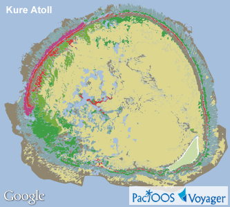
Posted June 28, 2013To supplement the main Hawaiian islands, Voyager’s “benthic habitats” category now contains NOAA shallow-water benthic habitat maps for the Northwestern Hawaiian Islands (NWHI), which contains the Papahānaumokuākea Marine National Monument. These maps include French Frigate Shoals, Kure Atoll, Laysan Island, Lisianski Island, Maro Reef, Midway Islands, Necker Island, Nihoa Island, as well as Pearl and Hermes Atoll. Along with other Insular Pacific regions added earlier this month (American Samoa, CNMI, Guam, and Palau), this completes Voyager’s collection of available benthic habitat published surveys in PacIOOS regions.
Example Voyager screenshots of NWHI benthic habitats (view legend):
 |
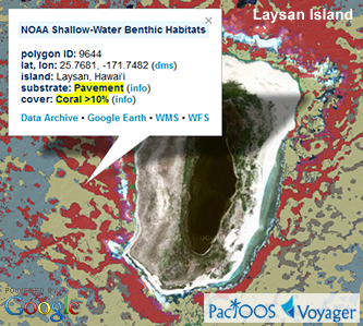 |
NOAA’s National Centers for Coastal Ocean Science (NCCOS) produced these maps to support coral reef research and management. Habitat regions were digitally identified using machine-automated spectral classification of orthorectified satellite imagery. For a variety of reasons, NOAA used a different benthic habitat classification scheme for NWHI compared to other regions across the Pacific. While many classes are similar, they are not categorized as biological cover types, geomorphological structure types, and geographic zones. Instead, a hierarchical scheme was used to flexibly denote substrate category (e.g. unconsolidated and hardbottom), structure (e.g. linear reef or pavement), and cover (e.g. coral, coralline algae, or macroalgae). A total of 45 detailed benthic habitat classes were identified in the NWHI. For simplification and to more easily distinguish cover types, these are presented in a set of seven aggregated benthic habitat classes. Clicking on the map produces a pop-up with the detailed classification at that location.
In addition to the above, this Voyager update includes a new benthic habitat auto-selection utility. This allows a benthic habitat overlay for a given island (e.g. Guam, Oʻahu, Tutuila, etc.) to be automatically selected based on the current map view. While the “auto-select” option is checked, Voyager will continue selecting an appropriate benthic habitat overlay after panning or zooming the map.
PacIOOS has generated a Web Map Service (WMS) and Web Feature Service (WFS) from the NOAA/NCCOS Shapefiles. These interoperable Open Geospatial Consortium (OGC) standards will help users who may want to incorporate data and map imagery of these layers into other mapping applications: WMS GetCapabilities • WFS GetCapabilities.
For further information, please visit:


