Surface Currents Buoy Observations : King-Poloa, Tutuila, American Samoa
NOTE: Click on the plot below for data at a specific time.
NOTE: This instrument does not report in real-time. New data are retrieved periodically.
start date: : temperature: wave height: wind: rain: currents: site:
Disclaimer: Near real-time data have not been quality controlled.
Disclaimer: Data are released in compliance with real-time quality control standards.
Disclaimer: Real-time data are provided as raw and unaltered. Results of quality control checks are provided within the data set.
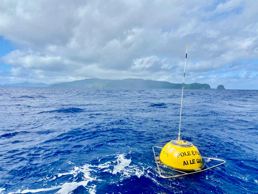
The PacIOOS wave buoy off Poloa (CDIP #273; NDBC #51214) measures surface currents approximately 2.5 miles (4 km) northwest of Legaotaema Point and Cape Taputapu offshore of Poloa Bay and Poloa Village Marine Protected Area at the western end of Tutuila Island in American Samoa. Data are transmitted every 10 minutes. This Datawell Directional Waverider DWR4 buoy uses an acoustic current meter (ACM) to measure the speed and direction of ocean currents at approximately 1 meter below the surface.
PacIOOS, in collaboration with partners, is proud to name this wave buoy the “King-Poloa Buoy” in honor of the late Christopher J. King. This name pays tribute to Chris’ invaluable contributions not only to the siting of this buoy but also to the people of American Samoa. Chris, a lifelong resident of American Samoa with family roots in Poloa village, played a pivotal role in ensuring the success of this wave buoy. His deep local knowledge and insights were instrumental in selecting the optimal location for the buoy, ultimately saving it from potential challenges. Beyond this specific project, Chris’ dedication extended far and wide. He served as the Director of the American Samoa Port Administration and was a tireless advocate for safety, ocean data collection, and ocean awareness within the community. Chris was known for his genuine warmth and ability to bring people together. He was a true bridge-builder, deeply invested in the well-being of his community. His passion for American Samoa and the community shone through in everything he did. More than just a colleague or leader, Chris was a friend to all. He had a remarkable ability to make everyone feel welcome and appreciated, his jokes and good-natured teasing bringing smiles and laughter wherever he went. The King-Poloa Buoy serves as a lasting testament to Chris’ legacy – a testament to his dedication, his community spirit, and his unwavering commitment to the safety and well-being of the people of American Samoa.

Instrument site. Credit: Ella Ashford.
The King-Poloa wave buoy is owned and managed by PacIOOS. The U.S Integrated Ocean Observing System (IOOS) provided the initial funding to purchase this buoy. Other key partners include American Samoa’s Department of Port Administration, the National Park of American Samoa, NOAA’s National Marine Sanctuary of American Samoa, and community fishermen. Data are managed by the Coastal Data Information Program (CDIP) at Scripps Institution of Oceanography of the University of California, San Diego (UCSD). Long-term partnerships between PacIOOS, the U.S. Army Corps of Engineers (USACE), and CDIP enable data streaming into the PacIOOS website and PacIOOS Voyager.
View the latest Wave Observations, Sea Surface Temperature Observations, and Air Temperature Observations from the PacIOOS wave buoy at Poloa, American Samoa.


