Wave Run-Up Forecast : Kwajalein, RMI
Attention: The forecast is not accurate when a tsunami, tropical storm or cyclone watch/warning is in effect. For these events, please seek information for either tsunamis or tropical storms/cyclones. In case of a possible inundation event, please consult with local authorities and emergency responders to seek further information and direction.

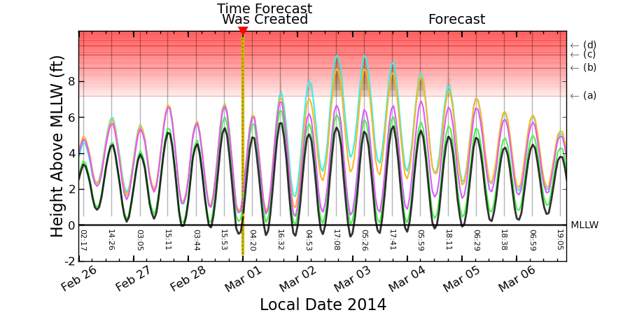
Four separate color-coded Wave Run-Up Forecasts are provided for the ocean-facing shorelines of the most populous parts of Kwajalein atoll. The Cyan, Orange, Magenta, and Green curves show the potential Inundation Height for the respective unarmored shorelines due to high tides and/or wind-generated waves. The forecasts are updated hourly.
The Black Curve displays the Observed and Forecast Sea Level at Kwajalein Atoll (Echo Pier) for the previous 3 days and the next 6 days, respectively, relative to Mean Lower Low Water (MLLW, a typical NOAA datum). Grey vertical lines show the associated times of the forecasted high sea level.
If the forecasted inundation height extends into the red shaded area, inundation is likely in unprotected low-lying areas. The higher the forecast the more severe the expected effects. One or more of the following threshold levels is/are shown in the red shaded area in the plot above: (a) Light Impacts, (b) Hazardous Impacts, (c) Critical Impacts. Click on the Examples tab for descriptions of the possible hazards.
Notifications
If you would like to receive notifications when the forecast for Kwajalein (or any other wave run-up forecast) reaches the impact stage, please register here:
The PacIOOS Wave Run-Up Forecast is a tool to predict the potential occurrence of high sea levels and wave inundation impacting Kwajalein Atoll. Storm events, high waves, extreme tides, or a combination of these factors can lead to potential inundation. Due to the low elevation of the Marshall Islands, communities are vulnerable to such events.
The tool was developed to increase community resilience and enhance preparedness by providing decision-makers, agency representatives, and community members with time to plan in advance of potential flooding events. The forecast is updated hourly (about 15 minutes after the hour) and dates and times are shown in local time.
The PacIOOS Wave Run-Up Forecast does not serve as a warning system. In case of a possible inundation event, please consult with local authorities and emergency responders to seek further information and direction. A similar forecast is also available for Majuro Atoll.
Contact
For more information, please contact Assaf Azouri. The Wave Run-Up Forecast Tool was developed by M. Guiles, D. Luther, and M. Merrifield within the Department of Oceanography in the School of Ocean and Earth Science and Technology (SOEST) at the University of Hawaiʻi at Mānoa.
To better understand the potential extent of the forecasted inundation, a few historical events are described below for your reference. The described events correspond to the letters indicated at the right edge of the plot.
(a) 7.6 feet – December 7, 2008
Caused by weak high tide and high wind-generated wave amplitude. Some flooding occurred, as well as some damage to roads and seawalls (according to an eyewitness report).
(b) 8.7 feet – February 7, 2012
Caused by high sea level with moderate wind-generated wave amplitude. Causeway flooding occurred and school closure was reported. View the Pacific Islands Report for more details
(c) 9.4 feet – March 2, 2014
Caused by high sea level with high wind-generated waves. Flooding and displacement was reported. Please view the USGS newsletter and find additional information below.
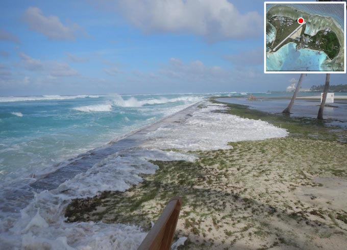
During the overwash event on March 2, 2014, seawater regularly topped the manmade perimeter berm on the island of Roi-Namur, Kwajalein Atoll, and covered large areas of the adjacent land surface. The inset shows the location of the photograph. Photo credit: Peter Swarzenski, USGS.
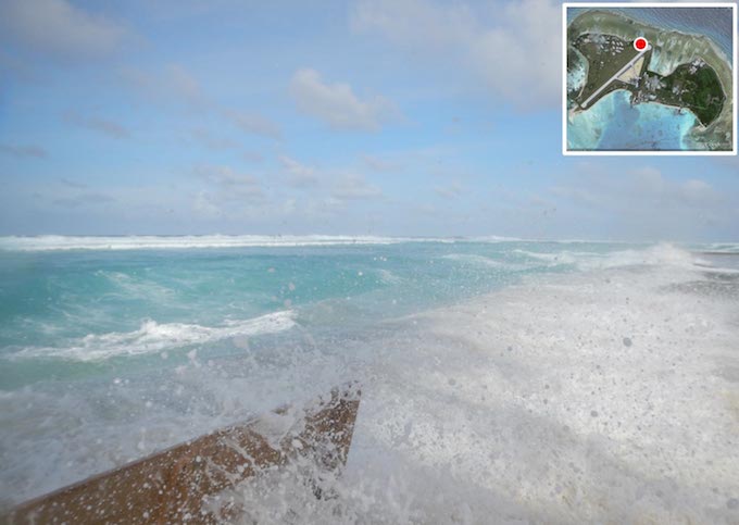
Waves overtopping the perimeter berm on the north shore of Roi-Namur, Kwajalein Atoll, during the March 2, 2014 overwash event. The inset shows the location of the photograph. Photo credit: Peter Swarzenski, USGS.
(d) 9.9 feet – December 8, 2008
Caused by moderate high tide and very high wind-generated wave amplitude. Major flooding and damage at Roi (according to an eyewitness report).
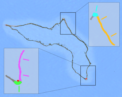
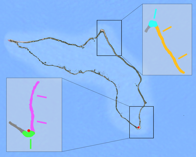
Kwajalein Shoreline Angles Used for Calculation
Kwajalein Atoll is depicted in this figure showing the four main directions used in the calculation of the wave height contribution to the forecast inundation. Seaward angles are: Cyan = 10°, Orange = 60°, Magenta = 105°, and Green = 190°.
Description of Kwajalein Wave Run-Up Forecast

For each of the ocean-facing shorelines listed above, a color-coded Wave Run-Up Forecast was created. No forecasts are currently provided for the gray-shaded areas of the atoll. The Cyan, Orange, Magenta, and Green curves show the potential Inundation Height for the respective unarmored shorelines due to high tides, multi-day sea level variations and/or wind-generated waves. If the forecasted inundation height extends into the red shaded area, inundation is likely in unprotected low-lying areas. The forecasts are updated hourly. For the 3 days prior to the “Time Forecast Was Created,” the colored curves are showing the last valid forecast for each date/time.
The Black curve displays the Observed and Forecast Sea Level at Kwajalein Atoll at Echo Pier (inside the atoll at its southern end) for the previous 3 days and the next 6 days, respectively, relative to Mean Lower Low Water (MLLW, a typical NOAA datum). Grey vertical lines show the associated times of the forecasted high sea level. The Sea Level Forecast (also updated hourly) includes tides and multi-day sea level variations, but does not include any wind-generated wave effects.
Directionally-Filtered Wave Heights

The Cyan, Orange, Magenta, and Green curves in this plot show the forecasted significant wave heights for each of the respective shorelines 6 days into the future (to the right of the “Time Forecast Was Created”). The forecasts are based on directionally filtered wave spectra provided by the NOAA Wave Watch III Global Forecast System – Wave (GFS-Wave) model. Appropriate spectra near Kwajalein Atoll are accessed via the links to model data provided on that page via FTP, https, OPenDAP, or Grib Filter. For the 3 days prior to the “Time Forecast Was Created,” the dashed curves are showing the last valid forecast for each date/time. If available, significant wave heights based on directionally filtered observations are also shown, plotted as colored circles.
An archive of previous forecast plots can be accessed below. Select a day of interest from the calendar, or use the slider tool to quickly navigate through all available images. Two historical forecast plots are provided for each day, generated at 6:00 AM and 6:00 PM of the local time zone. To view the most recent forecast and to learn more about the different components of the graph, please go to the Forecast tab.
date: :

Loading archive...


