

High Sea Level And Wave Run-Up Forecasts
High Sea Level And Wave Run-Up Forecasts
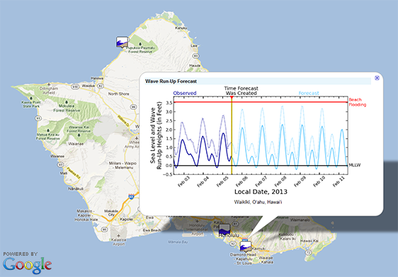
Posted February 5, 2013Two new overlays have been added to Voyager’s “hazards” category: high sea level forecasts and wave run-up forecasts at select harbors and beaches around the Pacific. Clicking on a map icon produces a pop-up window with a time series plot of the most recently available observed and predicted conditions.
High sea level forecasts predict water level inundation (slow flooding of the land) due to the combined effects of tides, winds, and ocean currents. These forecasts can alert locations up to six days in advance if the sea level will be at or above a pre-determined threshold of extreme sea level height. When this threshold is exceeded, flooding at the lowest lying land is expected.
Wave run-up forecasts similarly predict inundation but include the influence of ocean waves. Wave run-up is the maximum height reached by waves along the shore relative to low tide (mean lower low water (MLLW), which is the average height of the lowest tide recorded at each site). These forecasts can alert locations up to six days in advance of the potential for beach flooding and/or overtopping of nearby roadways.
For more information about how these forecasts are generated, please visit PacIOOS High Sea Level Forecasts and PacIOOS Wave Run-Up Forecasts. Forecasts at additional locations are planned for the future.


