Voyager Overlays Organized Into Super-Categories
Voyager Overlays Organized Into Super-Categories
Posted September 16, 2014
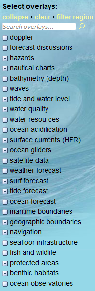
With hundreds of possible overlays now available through PacIOOS Voyager, the long list of 25 map categories along the left-hand menu bar had grown unwieldy (“spaghetti”, one user called it). In an effort to condense this list and help steer users towards their data of interest, we now introduce a set of 7 super-categories: hazards, observations, remote sensing, forecasts, biology, navigation, and seafloor.
Organizing Voyager’s overlay list: (a.) the old way: 25 categories; (b.) the new way: 7 super-categories; (c.) expanding the super-categories:
Still having trouble finding what you’re looking for? You can also try using Voyager’s
overlay search bar, introduced earlier in May.