

Monthly Archives: June 2015
Kwajalein Wave Run-Up Forecast
Posted June 30, 2015Voyager now includes a new wave run-up forecast for Kwajalein Atoll in the Republic of the Marshall Islands (RMI). Developed by Martin Guiles, Doug Luther, and Mark Merrifield of...
Digital Elevation Models (DEMs)
Posted June 18, 2015Voyager screenshot of USGS DEM for Tutuila, American Samoa with black 100-m elevation contour: Voyager now provides access to numerous land surface digital elevation models (DEMs), which can be...
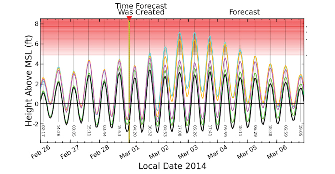
Kwajalein Wave Run-Up Forecast
Posted June 13, 2015Due to the successful development and implementation of the wave run-up forecast for Majuro, Marshall Islands, PacIOOS also developed a forecast for Kwajalein Atoll. The new PacIOOS wave run-up...
HFR Surface Currents: Hilo Bay
Posted June 10, 2015PacIOOS recently deployed new high-frequency radio (HFR) antenna arrays to estimate surface currents in and around Hilo Bay on the windward (Eastern) coast of Hawaiʻi Island (Big Island), extending...


