Tropical Storm Madeline and Hurricane Lester
Tropical Storm Madeline and Hurricane Lester
Posted September 1, 2016**Update: The State of Hawaiʻi is no longer under Hurricane Watch.**
Tropical Storm Madeline has weakened and is projected to move away from the main Hawaiian Islands. Hurricane Lester is currently rated as a Category 3 Hurricane and could potentially impact part of the State of Hawaiʻi. A Hurricane Watch has been issued for Hawaiʻi Island, Maui County, and Oʻahu. PacIOOS offers various observations, forecasts, and data tools that allow you to track current and projected oceanic and atmospheric conditions. Please refer to NOAA’s National Weather Service advisories to find the latest watches and warnings.
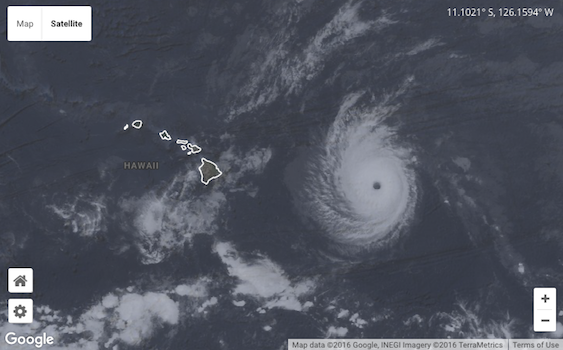
Clouds Imagery
Zoom into the global clouds imagery to find the latest compilation of satellite images (see image above). The imagery is provided by the University of Wisconsin-Madison Space Science and Engineering Center (SSEC) and updated every hour. Tip: Modify your viewing options in the map settings, to e.g., select coastlines, change the opacity, and more.
PacIOOS Atmospheric Forecast
PacIOOS’ WRF model offers an hourly 7-day forecast for wind speed and direction for the main Hawaiian Islands. Select a location of interest by clicking into the map viewer—an interactive graph will appear below. Higher resolution wind forecasts are also available for the Maui-Oʻahu area, and for the island of Oʻahu. A similar set of forecasts is also offered to project precipitation (rain). Choose between the main Hawaiian Islands, the Maui-Oʻahu area, and the island of Oʻahu.
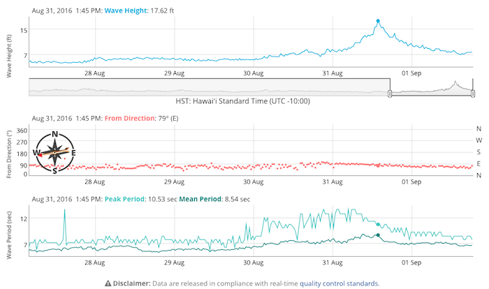
PacIOOS Wave Buoys
Find the most recent wave height, period, and direction recorded by the PacIOOS wave buoys. Considering the direction of the approaching Hurricane Lester, windward (east) facing buoys, such as the Hilo Bay and Mokapu wave buoys, will most likely see the largest wave heights. For tropical storm Madeline, wave heights peaked at 17.62ft on August 31, 2016 at the Hilo Bay wave buoy off Hawaiʻi Island (see image below).
PacIOOS Wave Forecast
The 5-day, hourly wave forecast for the main Hawaiian Islands provides you with an outlook of the projected wave height, direction, and period. Choose a timeframe of interest and select a location of interest by clicking into the model; an interactive graph will be generated below the map viewer. Higher resolution wave forecasts are also available for the islands of Hawaiʻi, Oʻahu, Kauaʻi, and Maui County.
PacIOOS Water Quality Monitoring
In case of heavy rains, the nearshore sensor NS02 located at the Hawaiʻi Yacht Club, Oʻahu, can serve as an indicator of the severity of the storm and its associated impacts on coastal waters. A drop in salinity means significant amounts of fresh water are entering the ocean through the Ala Wai Canal. Turbidity levels (water clarity) might increase, as large amounts of runoff from land enter coastal waters. The storm runoff, or “brown water”, can contain sediments, pollutants, and contaminants.
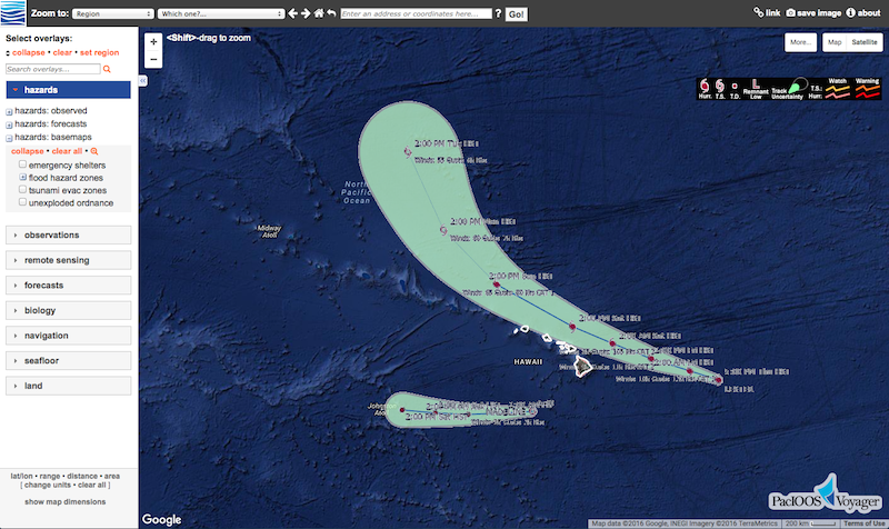
PacIOOS Voyager
All PacIOOS forecasts and observations and additional datasets can also be viewed in our comprehensive online mapping platform, PacIOOS Voyager. Combine layers, choose view options, download data, and more! Shown below is the projected path of Hurricane Lester from NOAA’s National Weather Service.