

Tsunami And Flood Zones Now In Voyager Mobile
Tsunami And Flood Zones Now In Voyager Mobile
Posted December 4, 2013Tsunami evacuation zones and flood hazard zones for the State of Hawaiʻi are now available in Voyager Mobile. Additionally, a “shelter” button is provided on these maps to show/hide emergency shelter locations throughout the main Hawaiian islands. With the new map tools added to Voyager Mobile earlier today (see below), the user can also quickly find their current location on the map to see whether they fall within these zones and where and how far the nearest shelter is. When used on a smart phone these utilities could help guide users to safety in times of impending danger while on-the-go.
Voyager Mobile screenshots of Waikīkī tsunami evacuation zones (left) and flood hazard zones (right); the user’s position is marked at the center of each map and nearby emergency shelters are shown with school house icons:
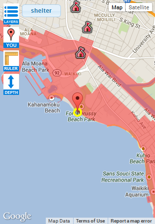

Each of these data layers was obtained from the Hawaiʻi Statewide GIS Program. Their respective sources include the Federal Emergency Management Agency (FEMA) (flood hazard zones) and the Hawaiʻi State Civil Defense (tsunami evac zones, emergency shelters). Note that FEMA is still assessing flood hazard zones for the Big Island. For interoperability, PacIOOS also provides Google Earth KML for the tsunami evacuation zones as well as a Web Map Service (WMS) and Web Feature Service (WFS) for the flood hazard zones.


