

Updated NOAA Coral Reef Watch Products: Version 3.1
Updated NOAA Coral Reef Watch Products: Version 3.1
Posted November 29, 2018PacIOOS has updated Voyager’s suite of NOAA Coral Reef Watch (CRW) coral bleaching monitoring products from version 3.0 to version 3.1. While the prior time series only dated back to 2013, these global, near real-time, satellite-derived, daily 5-km data sets now span 33 years from 1985 to the present. This product suite includes daily average night-time sea surface temperatures (SST), SST anomalies, coral bleaching hot spots, and degree heating weeks (DHW). Version 3.1 also provides a 7-day maximum coral bleaching alert area (BAA) product so users can more easily identify areas of concern. These variables can be found in Voyager’s overlay menu under the headings “remote sensing” > “satellite data” > “CRW (coral, SST)”.
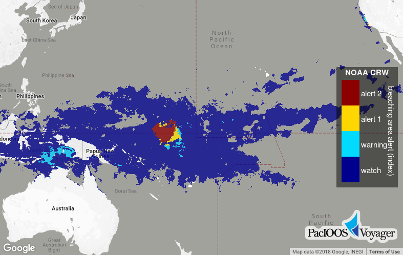
Voyager screenshot of NOAA CRW coral bleaching alert areas around the Pacific, highlighting the potential for bleaching in or near the Republic of the Marshall Islands (RMI) on November 26, 2018:
While the previous version was based solely on the NOAA/NESDIS operational daily global 5-km geostationary-polar-orbiting (Geo-Polar) blended night-only SST analysis, this update is built on CRW’s new CoralTemp Version 1.0 product, a daily global 5-km SST dataset combined from the following:
- NOAA/NESDIS operational near-real-time daily global 5-km geostationary-polar-orbiting (geo-polar) blended night-only SST analysis
- NOAA/NESDIS 2002-2016 reprocessed daily global 5-km geo-polar blended night-only SST analysis
- United Kingdom Met Office 1985-2002 daily global 5-km night-only SST reanalysis of Operational SST and Sea Ice Analysis (OSTIA)
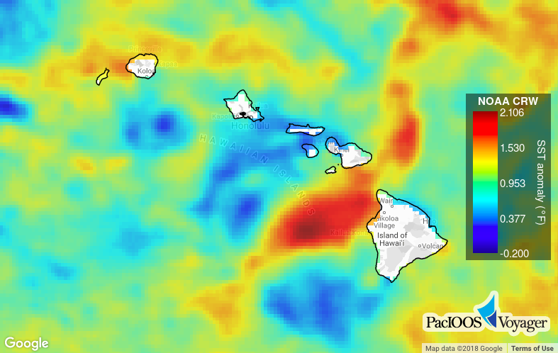
Voyager screenshot of NOAA CRW CoralTemp SST anomalies around the main Hawaiian islands, highlighting higher than normal temperatures along the west coast of Hawaiʻi Island on July 3, 2018:
This NOAA CRW version 3.1 update now replaces the older version 3.0 in our PacIOOS data servers, including THREDDS Data Server (TDS), Live Access Server (LAS), and ERDDAP. Through these data servers, interoperable data access is provided via OPeNDAP, Web Map Service (WMS), Web Coverage Service (WCS), NetCDF Subset Service (NCSS), and other services. Formal metadata can be found here. These data are downloaded and aggregated daily from NOAA CRW: click here for further information.


